burrel2
-
Posts
2,388 -
Joined
-
Last visited
Content Type
Profiles
Blogs
Forums
American Weather
Media Demo
Store
Gallery
Everything posted by burrel2
-
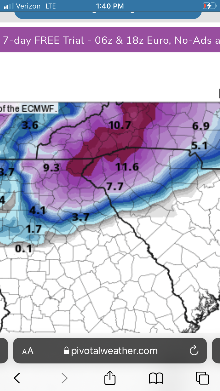
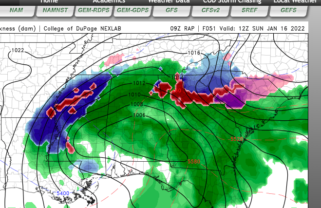
CMC looking amazing.
-
wth is going on with these models? are they going to bust 6-7 degree's too cold less than 18 hours out?
-
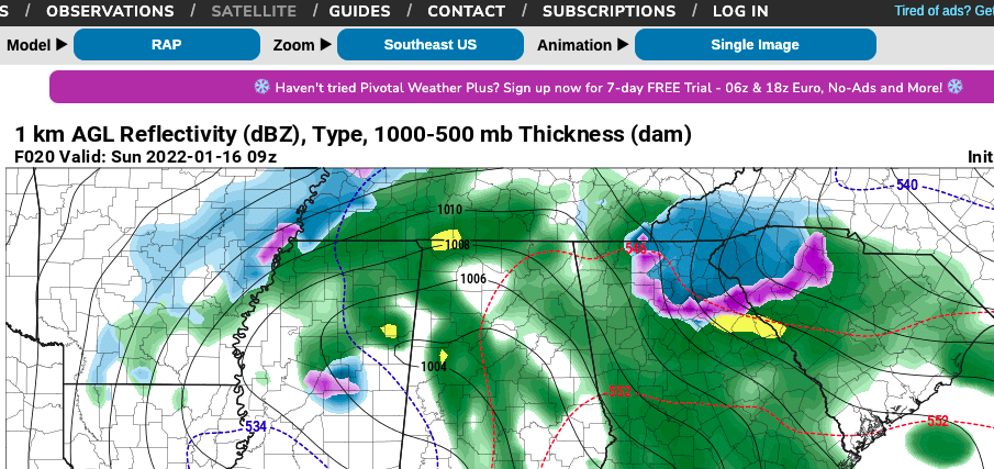
Crush Job on the 13z Rap for NE Georgia and Upstate, SC.
-
IMO, we should be mostly/all snow until 6-7am at the earliest. That gives us a 3-4 hour window for accumulations. If the initial fronto band can really perform for us we can get 3-5 inches I think before the changeover to sleet. Time will tell.
-
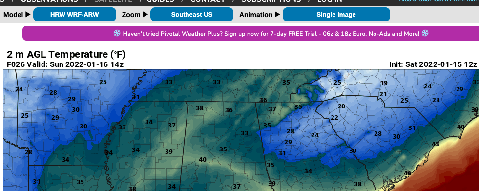
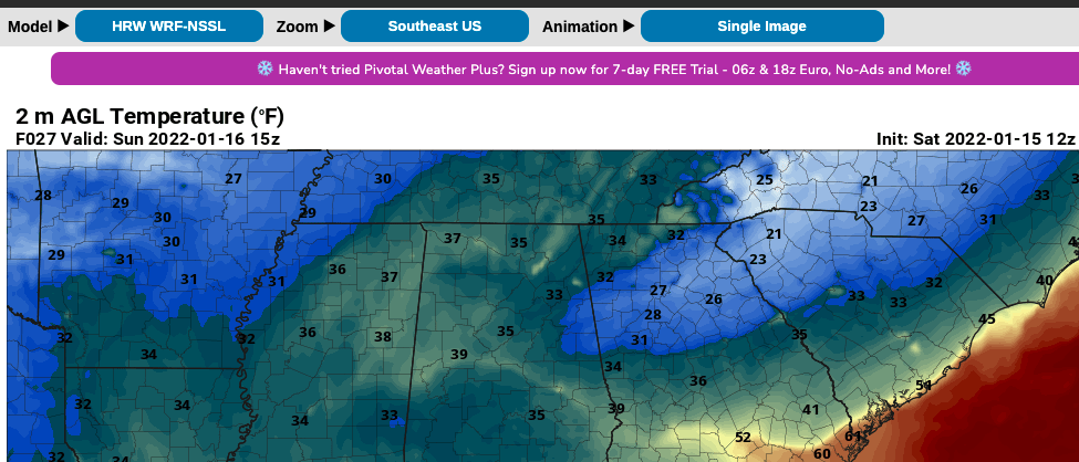
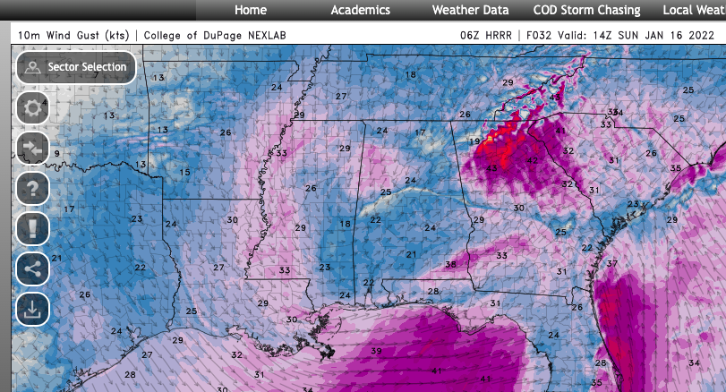
Easy to see why the Hrrr is so aggressive with bringing the cold air down with the wedge. Wowza. Never remember a wedge with 40-50mph gusts before.
-
The 06z Hrrr had GSP at 38/25 at midnight. The latest 11z run has GSP at 37/22 for midnight. 06z had Greenwood at 39/30, 11z is at 41/22. So even the Hi-Res models showing super cold/dry air are trending colder/drier at appears. This could be bad news for the Columbia area in terms of power outages.
-
Hrrr and RAP are really blowing in the cold/dry air with the wedge ahead of our storm. It may be a little too early to say this, but it's pretty clear the ole goofy GFS has once again dropped the ball on surface temps/dew points under classic CAD. Very little chance the temperatures it's been spitting out for CAD regions of GA/SC the last few days come close to verifying. As such, this is looking like one heck of an ice storm for places like Elberton, Greenwood, Abbeville, Laurens, Irmo, up to South Charlotte.
-
The grocery store was a mad house here. All registers open and lines 10-15 people deep. Almost all the staple items sold out. Chris justice must be scaring these folks!
-
Literally no model has trended towards less snow in southern oconee/pickens county in the last 24 hours. All of them other than the GFS are showing accumulating snow with the frontal band. The hi-res models that have come in to range look great for this area... and NWS GSP cuts totals to 0? lmao
-
Of course every storm is different. But just to play devil's advocate. Here are my post-storm notes for the snow I received last year... Date Total Min Temp during precip Mixing Notes Feb 6, 2021 1.75-2 32.2 Miller a with -3 850s but warm boundary layer, started off as rain and 39 wetbulb, heavy rates flipped it to snow. Hrrr nailed transition and precip maxima, nam was way too warm at surface and too quick with warm nose and too dry.
-
This is some temp and qpf data i've been taking for Clemson, SC. Interested to see if the GFS busts too high on temps. It's in chronological order with the top data being the oldest. Go ahead and crown me king of the weenies for doing this. I don't care. lol 7:00 PM 1:00 AM total liquid 1am 7:00 AM total liquid 7am snowfall notes about snowfall 18z gfs 41/32 37/36 .21 liquid 34/32 1.21 2 kuchera 18z Nam 3k 37/32 32/29 .05 liquid N/A N/A N/A 18z Nam 38/29 32/28 .02 liquid 27/23 0.57 18z RGEM 42/25 37/28 .01 liquid 29/27 0.65 5 kuchera 12z Euro 41/31 35/30 .02 liquid 27/23 0.54 8 12z Ukmet 40/33 38/33 .00 liquid 33/33 0.11 7 00z Nam 37/29 33/30 .02 liquid 28/23 0.5 00z Nam 3k 38/30 35/26 .00 liquid 27/23 0.3 0 kuchera through 7am 00z gfs 41/32 37/36 .08 liquid 33/32 1.04 3 kuchera 00z RGEM 42/23 38/25 .01 liquid 30/27 0.68 6 kuchera 00z EURO 39/32 35/31 .04 liquid 28/26 0.76 8 00z Ukmet 40/33 37/34 .00 liquid 35/34 0.06 7 06z RGEM 43/24 37/28 .01 liquid 30/28 0.54 4 kuchera 06z Nam 3k 39/31 36/26 .00 liquid 28/24 0.28 1 kuchera through 7am 06z Nam 06z gfs 41/33 38/37 .20 liquid 36/33 1.17 3 kuchera 12z NAM 39/30 33/32 .12 liquid 30/27 0.52 1 kuchera backside snow 12z Nam 3k 40/31 37/26 .00 liquid 28/25 0.26 4 kuchera through 7am 5 through 7pm 12z Hrrr 39/34 36/33 .00 liquid 31/29 0.13 1 kuchera through 7am 12z gfs 41/32 38/36 .11 liquid 33/32 0.97 4 kuchera 12z ukmet 40/36 39/36 .00 liquid 33/33 0.52 6 12z euro 39/33 35/33 .07 liquid 30/27 1.03 10 18z NAM 37/33 35/32 .00 liquid 28/25 0.43 2 kuchera 1 front 1 back 18z Nam 3k 37/32 36/30 .01 liquid 28/25 0.43 3 kuchera through 7am 4 through 7pm 18z Hrrr 39/31 36/29 .00 liquid 28/28 0.23 2 kuchera through 7am 5 through 1pm
-
I think north of 85 in SC is looking good for 4-8 inches of snow. My confidence level for that is pretty good all things considered. 8-12 possible north of hwy 11 and 10-12+ in the sc mountains above 1500ft.
-
It is what it is. Both January 2011 and February 2014 had a warmnose/sleet line push through as well. Both immediately after the frontogenical band moved through. Both were great snow events anyways. )except Feb 2014 for Pickens bc we got screw holed on the fronto band). my point being if we hold on to snow until the dry slot gets close and rates decrease… who cares! We got our dumping! Especially considering it’ll be mid 20s afterward so it’s not getting washed away or anything
-
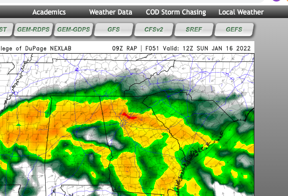
This is 10:1 so probably a little overdone. But even accounting for some loss to pingers at the end and a little melting at the start it should be a solid 6-8 hammer.
-
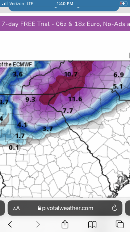
Euro is just an absolute crush job for north east Georgia and the northwestern upstate,sc. it starts ripping snow around midnight and the warm nose doesn’t move through until the dry slot arrives around 7-8am.
-
No but I’m glad it’s on the cold and snowier side of guidance which aligns more with the euro, ukmet, rgem opposed to the gfs/nam which give the upstate very little snow
-
she's a beaut clark!
-
12z Hrrr looks way more south and suppressed when comparing to the 3k NAM. 5h low is weaker and passing well south of the ark/la/tex region.
-
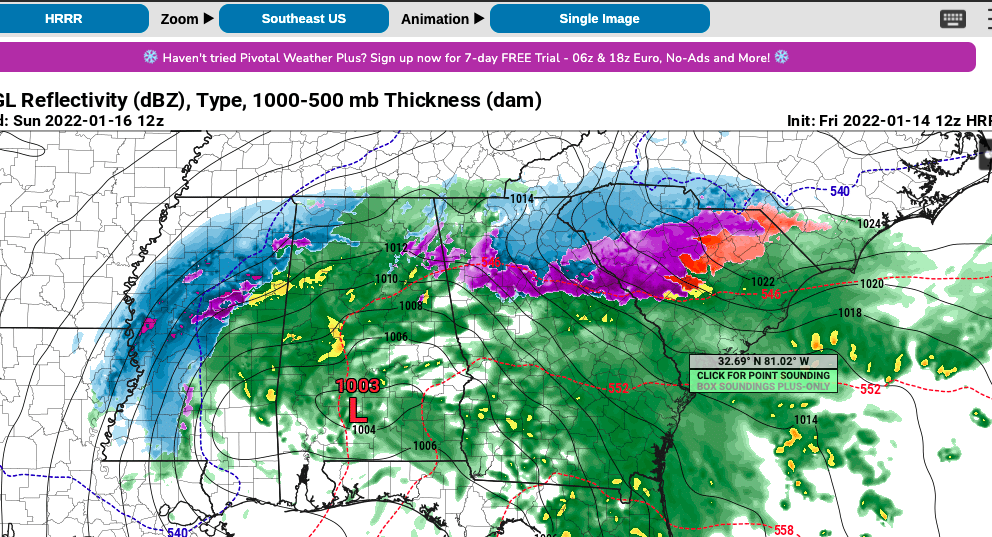
9z RAP is super bullish on the Northeast Georgia snow. It takes a southern track with the 5h low similar to the ukmet and hrrr. So for those counting in NE Georgia/Upstate SC we have: RAP,Hrrr(extrapolating), Ukmet, RGEM,CMC, Euro all showing solid front end thumps. GFS is too warm and the NAM/3kNAM are decent but less acumulations than the first group of models. ICON is also borderline.
-
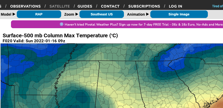
If you guys are obsessed with over analyzing everything like me… go look at the 48hr hrrr and tell me what is going on with that random wave in the northeast that’s wrecked our high pressure and will probably lead to our storm not riding up the coast? Is it smoking crack or what? I haven’t seen that on any other modeling.
-
18z GFS would dump 6-10 inches of snow here before warm nose/changeover to sleet, but the dang surface temperature is too warm that whole time. For some reason the GFS shows literally zero cold air advection from CAD, even though it's showing a 10-15 knot NE wind??? The temperature just hangs at 36-37 for four or five hours. Every other model has the temp rapidly dropping to around freezing and below as soon as precip starts. Here is a chart of Surface temps/Dew points and total qpf at 1:00am and 7:00am. Will be interesting to see how this verifies. I'm betting on the Euro/NAM/RGEM for surface temps. Clemson, SC 7:00 PM 1:00 AM total liquid 7:00 AM total liquid 18z gfs 41/32 37/36 .21 liquid 34/32 1.21 18z Nam 3k 37/32 32/29 .05 liquid N/A N/A 18z Nam 38/29 32/28 .02 liquid 27/23 0.57 18z RGEM 42/25 37/28 .01 liquid 29/27 0.65 12z Euro 41/32 35/31 .02 liquid 27/24 0.54 12z Ukmet 40/33 38/33 .00 liquid 33/33 0.11
-
HRRR is very good inside 18hrs, imo. I've seen it bust horribly before but more often than not it has a more accurate depiction than other hi-res models.
-
48hr 18z HRRR has the 5h low over Dallas...??? That's way farther south and west of most guidance. Also very positive tilted/sheared. I've never followed the "long range" Hrrr; is it garbage?
-
Man, for once it seems like the western upstate may be a favored jackpot zone in a major winter storm. Hasn't happened since?? never really.... Jan 1988 and Jan 2011 were major hits region wide. I'll remain skeptical until the snow is falling though, but maybe we finally jackpot and get 6+ inches of snow. (would be the first time since 1988 for my back yard). Euro,NAM,CMC,RGEM,ICON,UKMET all show a 6+ inch front end thump here before the warm nose and dryslot move in.
-
EPS mean track looks like a good bet. The low is most likely going to track inland over NC It’s just not going to plow through the wedge to get there like the gfs wants to do. Instead you’re going to see the low transfer/propagate from southwest Alabama to just off the coast around Charleston,sc. then ride the coastline up in to NC coastal plain. IMO