

burrel2
-
Posts
2,388 -
Joined
-
Last visited
Content Type
Profiles
Blogs
Forums
American Weather
Media Demo
Store
Gallery
Posts posted by burrel2
-
-
14 minutes ago, mrdaddyman said:
Believe me, you don't want to see it. The track was further South but it's trip up the coast after that is not a good track for us.
That looks awesome for Upstate SC and NE Ga. Further south track and better wedge signature is what we're rooting for here.
-
 1
1
-
 1
1
-
 1
1
-
-
I'm thinking the CAD is being extremely under modeled at this point. Most of the globals have our high in near perfect position. I think we will see the Hi-Res models paint a different picture with regards to sleet/freezing rain once they get in range.
As a general rule, you can normally shave 4 or 5 degrees off whatever the GFS is showing in this time range in a CAD setup. If you do that for this storm it's a devastating ice storm all the way down to Lookouts house. The GFS is already showing some ice to that point as it is.
-
 1
1
-
-
New ICON out to 96hrs look much flatter out ahead of our storm compared to the 12z run. Could be a good trend if all the 00z models follow suit.
-
5 minutes ago, wncsnow said:
Where do you get ensemble numbers?
weatherbell; don't think I can post b/c it's a paid site.
-
Euro Ensemble members are also back to being absurdly bullish for the upstate. Over half of them paint >3 inches here, with a mean close to 6 inches.
Incredible that both the GFS and Euro ensemble means are roughly 6 inches here this far out.
-
3
-
-
I will say, a 6 inch snowfall mean on the GEFS for my back yard, at a 6 day lead time is very unusual. Not that it means anything. I'll ride it and the new GFS right off the cliff I guess.
-
2
-
-
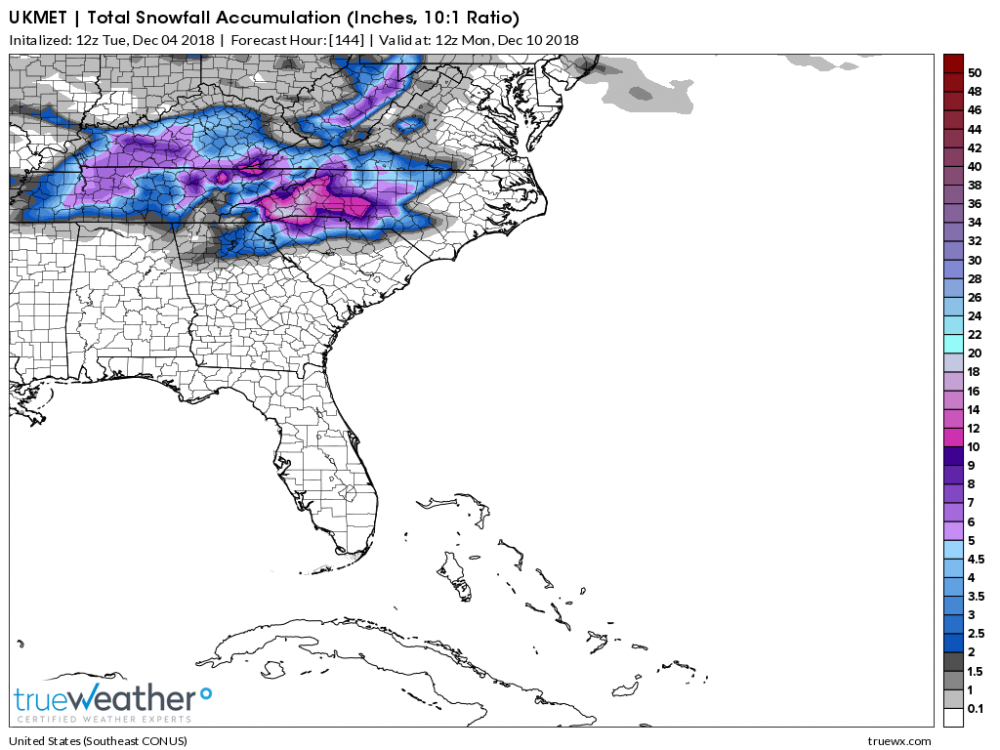
Ukmet looks like a dang close match to the new GFS to me. Maybe just a few hours slower, but with significantly better wedging out in front of the storm. Also maybe not quite as deep/strong as the new GFS.
That being said, I'm guessing the ukmet is a major hit well down in to upstate SC and NE Ga. Especially with the better early wedging.
-
1
-
-
Looks like a northern jet wave crashes down just in front of our storm causing the stall/slide. Our storm wave is so broad it keeps the snowing going for quite some time in this scenario.
-
6 minutes ago, Buddy1987 said:
Looks like s/w trended a little stronger and north. Maybe the reasoning behind mixing even up my way at the onset due to warmer mid levels infiltrating resulting from less confluence. I really believe until the Euro has the support it’s the outlier as of right now.
I'm not saying it won't come way north eventually, but the euro is supported by the ukmet and jma right now. The GFS and CMC are really the only models on the more amped side of guidance right now.
-
Just now, SnowGoose69 said:
The high is too far north for those sorts of totals into GA and SC. That would at best be mostly sleet there. Think January 88. It was a flatter setup than this was or at least a weaker low, later in the season and still most of NRN AL and GA saw sleet. This probably is north of the 12Z Euro in the end but even if that verifies dead on those places south of the TN-Spartanburg line are likely sleet. Atlanta might even be rain
I'm not that excited at all about the snow prospects in the Upstate, or even in Central NC for that matter. Mid level cold air looks too marginal. I think large areas of sleet/freezing rain is a good bet for this storm. I'm not picky though.
-
1
-
-
13 minutes ago, TARHEELPROGRAMMER88 said:
What are the totals for SE NC on the control run?
Jackpot for SENC is around a foot between Lumberton and Wilmington. Less as you go north from that line. (Not sure on algothrims for the snow map, and how much of this is sleet/freezing rain)
-
1
-
-
I would say in the history of Euro ensemble runs... I've never seen a set that has looked that good in my life at 6/7 days out. It's beautiful!
-
Euro control run is a suppressed crush job from atanta to columbia to myrtle beach. I'm loving this supression trend. Lets keep this puppy south as long as we can!
-
4
-
 1
1
-
-
I just saw the snowfall maps from the Euro.... I'm at a 10 out of 10 now on the excitement meter. Sure would be nice for the Upstate of SC to jackpot for once in the last 30 years.
-
2
-
2
-
-
We will also be just two weeks away from the winter solstice. So, solar radiation is about as good as you can hope for in a winter storm.
-
2
-
-
My excitement meter is up to about an 8 out of 10 at this point. Seems like even in the more amped/miller B scenario's CAD favored area's should at least be in for some ice.
-
2
-
-
5 minutes ago, Iceagewhereartthou said:
Verbatim this run is a real mixed mess for the NW upstate. Liitle snow at front to mix to ice - maybe a couple inches total of mess. That line is really close to 85 as usual - that high needs to trend a little stronger and hang around a little longer. As always, Pickens/Oconee right on the line! Caution for everyone, wouldn't be surprised to see models lose this (especially North) over the next couple of days. If that happens as usual, don't panic just yet, there will be tons of changes ove the next week and who knows how this will acutally play out. Hearing a lot of reminders about CAD being underforecasted and that does happen a lot, but NOT ALWAYS, so don't count on it automatically. Incidentally, today's CAD was underforecasted, so far at least. High for me was 56, only made it to 50 so far.
Is Burrel, Wow, or Lookout on here yet, would like to hear your thoughts!
I'm here... pretty excited about the potential, but trying not to get too amped up yet. We've got another few days before we know if it's a real threat or not. The pattern certainly looks conducive.
-
2
-
-
2 minutes ago, Windspeed said:
A simple lat/long search... 990 mb? Looks about right.
LMAO, SENC was right!!!! This thing was only a cat 2 storm.... 80 miles away from the COC! lol
-
1
-
-
10 minutes ago, LongBeachSurfFreak said:
I wonder is there is anything out of point st. Joe. That, looking at a map is an area that should not be rebuilt. A long barrier island ending in a state park. That rest of it should be added to the state park.
You could say the same thing about PCB if the storms western eyewall had hit there, or 80% of the other major cities on the coastline.
-
1 minute ago, SENC said:
Strong Cat one.. I'm seeing the exact same damage.. (Yes I went through the eyewall of Florence), I reside 7 miles from landfall..
Interesting that the day of Florence I didn't see any significant wind damage video's, and actually heard most officials and storm chasers saying that the wind damage wasn't bad at all around Wilmington or anywhere else. A stark contrast from this storm huh?
-
1
-
-
1 minute ago, SENC said:
You have to remember, several quotes here from other members.. building(s) in the area(s) were 30+ years old, in other words, NOT up to "Hurricane" codes, AND Lotsa Mobile homes.. They said so them selves.. NOW they, (you know who you are) claiming Cat 5 Winds "destroyed" everything,, on Winds that didn't exist? (based on destruction)? double Standard don't you think? ON 30+ year old homes?
And yet DENY Data from Buoys? sorry @Lookout, I gotta say my piece.. I'm Sincerely, sorry Dude.. I've lived through so MANY Canes since 1969, this was a CAT 2 at Landfall..
Hypocrites..
Did you live through this one too? Or are you just speaking out of your ace from NC?
-
FYI, everyone on the ground in panama city/mexico beach is reporting that the damage is incomprehensible, including dozens of seasoned storm chasers.... but SENC can tell you from his couch 300 miles away that they are all WRONG!
-
1
-
-
I'm waiting for SENC to tell us how ridiculous icyclone Josh is being... since him center punching the strongest cyclones in the world for the last 15 years apparently doesn't compare to living in SE NC your whole life.
-
1
-
1
-
-
Just curious, if you guys think this was a cat 2, how would you classify Florence at landfall? A 60mph tropical storm?
-
1
-

December 8-10, 2018 Winter Storm
in Southeastern States
Posted
Yea, that vort dropping down from Canada on the Euro was super strong this time. Vort's change up there pretty wildly from run to run, and I think that's where most of our variance is coming from in the ensembles.