

burrel2
-
Posts
2,388 -
Joined
-
Last visited
Content Type
Profiles
Blogs
Forums
American Weather
Media Demo
Store
Gallery
Posts posted by burrel2
-
-
looks like nws GSP was right to go against ishomue with the NAM's thermal profile... lol
Too early to claim victory though, it could easily go the other way as the event unfolds.
-
 1
1
-
-
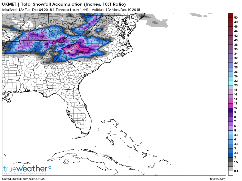
NAM drops 15 inches of cement paste on the northern upstate from walhalla to easley to greenville to spartanburg.

-
2
-
 1
1
-
 1
1
-
-
I honestly can't decide what it's going to do in the northern upstate. I think the most logical outcome is mostly cold rain, but there's definitely a chance we could get buried. I'll remain cautiously optimistic, but expect 1 inch of sleet accumulation for my storm total.
If that lead finger of precip could be mostly snow for us, we could really rack up. It appears the mid-levels will be borderline cold enough for the finger... but surface temps are around 35-37. If the mid-levels are cold enough, i imagine we could cool the surface down to 32-33 with heavy rates inside the finger.
Regardless, the mountains on the NC/SC border are going to get obliterated, both by the lead finger and the main storm. I'm calling the jackpot for the storm as somewhere around rosman/brevard with a total of 20 inches.
-
comparing hours 60 to 72 of precip panels with last nights ukmet and the 12z. The precip shield is definitely more suppressed, the high pressure is a good bit farther to the east, and the low pressure is a little slower. All good trends it appears.
-
5
-
1
-
-
4 minutes ago, snowinnc said:
Meh. I’m a bitter party of one. I love living in Raleigh and truly wouldn’t want to live anywhere else but I’m really tired of getting jack squat when it comes to snow. Charlotte getting more than us Wake County residents is a real WTF. I’m used to it for the Triad but Charlotte and upstate SC getting more? I’m convinced that we are just cursed when it comes to snow.
Upstate SC won't get more snow than Raleigh.
-
06z CMC trended the mix line further south in to the upstate Sunday morning compared to 00z. Still has mostly sleet/zr all the way to the nc/va border though.
-
One thing I'm concerned about for the upstate storm potential. I've noticed over the years, while CAD is always underdone on the models, an arriving CAD is usually a few hours later than models show. They usually arrive later, but hold out longer.
In the upstate, we are relying on the CAD arriving during precip late Saturday night. If it builds in a few hours later than expected, we will waste all the front side precip to rain. Something to keep an eye on.
I do fully expect the entire upstate to drop in to the upper 20's when the CAD entrenches though, and seemingly we still have quite a bit of precip left to go through Sunday evening. So even without the front end thump it should be significant. (I will say that the coverage of precip is more unpredictable after the initial band goes through, so it's possible we don't get the modelled qpf after Sunday morning). But even if we just get a few tenths it would be bad from an impact stand point with temps in the upper 20's.
For the upstate, I think the later precip arrives the better as it gives more time for CAD to build in. If we get in on the finger of precip streaking out ahead of the storm early Saturday... probably not good for us. (But great for franklinweather since he'll be snow then).
-
3
-
-
NWS GSP update... too low on the ice accumulations, imo.


-
-
Figures... on the most anticipated NAM run in the last 10 years.
-
Is the NAM running late for everyone else?
-
NAM has Spartanburg, SC at 35/21 with a stout NE fetch on Saturday night before precip arrives. Game on
I fully expect the Upstate to bottom out around 27 or 28 degree's Sunday morning as the heaviest axis of precip comes through.
-
 1
1
-
-
Nam is setting up for a major ice storm in Atlanta.
-
2
-
1
-
1
-
-
Just now, griteater said:
Just think, we have basically 48 hours of modeling left....that's an eternity for how things can change. We have a system that is going to bring a lot of warmth and juice out of the gulf into an airmass that is marginal aloft overall. Outside of the central and northern mountains, northern foothills, into SW VA, confidence should be tempered IMO for a big event. I post the snow maps like others, but I feel a little slimy doing it because heavy support for cold temperatures isn't there....and those maps are much heavier with snow than they should be along the edges. Wonder if anyone has the Eurowx site access...seems like they used to have much more tempered snow maps, etc.
Absolutely. I don't think anyone stays snow for the whole storm outside of the mountains and maybe the northern foothills. I would guess 6 to 10 inch amounts in the foothills to greensboro, with one to two feet totals confined to the mountains.
The snow maps,(IMO), are an excellent tool for tracking trends in the models, not so much for showing where snow will actually fall.
-
2
-
-
I'm getting pretty dang excited here. Keeping my expectations tempered that the upstate will undoubtedly be sleet for the majority of the storm, I'm going to say any snowfall accumulation will be a bonus in my book. The sleet may really pile up though as I expect us to go from 33/34 Saturday evening quickly down in to the upper 20's as the heaviest precip moves in.
Get your popcorn ready for the 18z NAM, i'm betting it's going to be a doozy.
-
2
-
-
Confluence on the new nam over new england is the best it's looked yet. It delays the high pressure building a little compared to last run, but leaves more cold air to work with overall.
-
7
-
-
4 minutes ago, mstr4j said:
Long time avid reader and first question ever on this AWESOME forum. My question for you weather experts is this (I Hope it's not confusing as I am still learning) - I understand that the NAM does a much better job at predicting and forecasting CAD events much better than global models. My question is however, does the NAM do well with forecasting where the actual location of the HP will be, or only if the HP is actually there then it determines the strength of the wedge. Virtually as the event is closer is it actually better to watch the NAM as a higher resolution model that doesn't do well with actual forecasting of where that High will be orrrrrrrrr watch the global models position of that HP and then go with the NAM's thermal profile? Make sense? Either way, been a great time following this forum and this HUGEEEE Winter Weather Threat
IMO, it doesn't generally do a good job predicting where things will be at 84 hours; however in this case, it appears to line up pretty well with the Euro at 84 hrs.
Because it somewhat matches the Euro at 5h, you can use the NAM's high scale resolution to get a more accurate prediction on surface temps/dew points, rain/snow/freezing lines if the Euro scenario plays out.
At least that's my weenie take on it...
-
FYI, here is my forecast i'm giving my friends & family for Upstate SC, if anyone cares to read. (disclaimer-I'm no expert)
My thoughts on the storm at this point: I'm thinking light rain/snow mix breaks out Saturday afternoon across the upstate, quickly mixing with and switching to sleet. I think the pre-dominate precipitation type will be sleet from Clemson to Greenville to Charlotte, with 1 to 4 inches of sleet/snow accumulations. The heaviest sleet accumulations will occur overnight Saturday through Sunday morning as temps bottom out around around 28 to 30 degree's.
South of there precip will start off as rain and switch to freezing rain late Saturday night, the possibility exists for significant ice accretions with power outages in a band from elberton to greenwood to rock hill.
For the far northern upstate in to the mountains, a significant portion of the storm should be snow leading to 6 to 12 inches of accumulations, with 12 to 20 inch totals in the mountains above 2000 feet.
There should be on and off snow showers Sunday evening through Monday morning across the entire region, doubt anything from this sticks with marginal surface temps, but some lucky people could pick up a quick few inches under any heavy banding features, including places in the southern upstate. (but I wouldn't count on it)
FYI: we're still 4 days out and things could change drastically. This is just my best guess at the moment.
-
3
-
 1
1
-
-
00z Nam has our northern supressor vort screaming down at hr 57 looking super healthy. Don't see how this run could get too far north with that feature.
-
2
-
-
20 minutes ago, DopplerWx said:
if the gfs is correct w/ the lp location then the warm nose would def mess with you guys. sounding in the midst of the precip shows it.

Yea, the warm nose coming up from the gulf would... but that's not the lee side "warm bubble" he's referring to, and doesn't explain the minima bubble on the Euro.
-
23 minutes ago, cwick20 said:
Burrell and Oconeexman, how do you feel about the dreaded warm nose that seems to get us with every storm. Seems to be showing it's ugly head again doesn't it? Western Oconee county and eastern Pickens county seem to be on the lower totals as usual with areas just to our east and west doing much better.
I'm not concerned. The Euro isn't showing a lee-side warm bubble from northwest flow over the mountains, as that's not where our cold air is coming from in this setup. 925mb temps are actually at their coldest on an axis through this area for our storm. (Thanks to CAD). It's a big reason we wind up getting mostly sleet in freezing rain events while places around us get more freezing rain.
I think the euro snow map has a bubble over Oconee county simply b/c it's showing surface temps at 33 degree's there for 5 or 6 hours while surrounding area's are 32/31. I've seen this before in CAD set ups, especially as the CAD is first coming in, it gets to places like anderson/hartwell a little faster than that small area over Oconee, but it's nothing to worry about right now. It will wind up being largely over-done, imo, (assuming the general depiction is right).
However, it is yet another reason why that small geographic area is literally the worst place you can live for winter weather.
-
8 minutes ago, griteater said:
IMO, the biggest thing to watch for the upstate to central NC crowd is how firmly the confluence pattern holds and is reinforced over the Northeast prior to the storms arrival. I think we'll pretty much be able to count on the wave trekking west to east and holding its strength
Yea, that vort dropping down from Canada on the Euro was super strong this time. Vort's change up there pretty wildly from run to run, and I think that's where most of our variance is coming from in the ensembles.
-
14 minutes ago, mrdaddyman said:
Believe me, you don't want to see it. The track was further South but it's trip up the coast after that is not a good track for us.
That looks awesome for Upstate SC and NE Ga. Further south track and better wedge signature is what we're rooting for here.
-
1
-
1
-
1
-
-
I'm thinking the CAD is being extremely under modeled at this point. Most of the globals have our high in near perfect position. I think we will see the Hi-Res models paint a different picture with regards to sleet/freezing rain once they get in range.
As a general rule, you can normally shave 4 or 5 degrees off whatever the GFS is showing in this time range in a CAD setup. If you do that for this storm it's a devastating ice storm all the way down to Lookouts house. The GFS is already showing some ice to that point as it is.
-
1
-


December 8-10, 2018 Winter Storm
in Southeastern States
Posted
38 and wet snow falling here now.