

burrel2
-
Posts
2,388 -
Joined
-
Last visited
Content Type
Profiles
Blogs
Forums
American Weather
Media Demo
Store
Gallery
Posts posted by burrel2
-
-
1 minute ago, Billypg70 said:
Just looking at observations.
Gainesville was reporting Heavy Snow & Freezing Fog 30/29 the temp dropped 2 degrees since last report. DP rose only 1 degree.
Great reports down stream.
Burrel are u in Pickens?
Any thoughts from Burrel or Lookout on Grenville County?
Tia
Yea, between clemson and central. I think greenville will get a coating to an inch. Precip really falls apart on all the modeling as you head to Spartanburg though.
-
Light fluffy flakes have started here now!! An hour ahead of schedule.
-
 1
1
-
-
34/28 here. No flurries yet. Based off the temp drops with the moderate snow around cornelia. I believe I will settle down to 31.5 or so when heavier precip sets in. All the models are around .15-.20 of liquid here. I'm starting to feel good about getting an inch on grassy surfaces imby.
-
2
-
-
4 minutes ago, LiQuiDBuD said:
GSP discussion mentioned the bullseye being around the Ellicott Rock area, which I'm 6 miles north. Hope you score well!
Can't. Freaking. Wait.
Sent from my Pixel 4 XL using Tapatalk
Anyone above 1500' in GA/SC/Southern NC mountains are a lock for 2-4 inches. You guys don't have to sweat boundary layer temps. In fact you guys above 2500' are probably in for some >10:1 ratio stuff with 850mb temps around -5C and surface temps in the upper 20's. Should get some nice big dendrites there
-
1
-
-
I'm seeing pics on facebook of the ground white with light snow falling in the Rossville, Ga area.

-
1
-
-
Temps were 41 degrees with that last storm where we got heavy wet snow that switched from light rain/snow mix. The surface layer was also completely saturated at 41 degrees and the 850-950mb layer was much warmer than it is now. Heavy snow continued for several hours here and temp dropped down to 34 degrees by 11am with that storm.
Grant it, that storm had more qpf to work with, but my point is that even if we warm up to 36-40 degrees over the next couple of hours, temps are still way below freezing at 950mb and above, and we had room for wetbulbing at the surface since dewpoints will be in the mid/upper 20's. We still want to stay as cold as possible b/c it looks like we're only getting .1-.3 of liquid with this storm and it will suck to waste any of it on mix/white rain. but there is no doubt NE GA/western upstate will see big fluffy snow today, and i'd be suprised if these area's don't get a dusting at minimum with 1-3 inches for gainesville/toccoa/clayton/cornelia/walhalla.
-
3
-
-
NWS GSP gonna be caught with their pants down again tomorrow.
-
1
-
 1
1
-
-
the in-house CJ model has updated on the news and now keeps the R/S line a good 20 miles south of i-85 for duration of the storm. Previous run had it just along 85.
-
1
-
-
2 minutes ago, Tacoma said:
you know there is wwa all around Asheville and Buncombe County, I would think looking at the future radar for tomorrow we would also be under the wwa. looks good for Buncombe according to that.
I'm not a mountain expert. But I think the trajectory with this storm creates downsloping in the Asheville area. As such, they don't get much appreciable precip.
-
On 2/3/2020 at 5:14 PM, burrel2 said:
Setup for Saturday night looks pretty good to me. Especially for the mountains. Just need the trough to dig a little more. Temps above the surface look good. Boundary layer may be problematic but there is still room for that to trend better.
My optimism paid off for a change! Still time for a bust though I guess...
-
1
-
-
Latest HRR at the end of its run, juicy...
 valid for 10am Saturday morning. Gainesville is gonna get plastered!

-
Look at that heavy band on the GFS radar simulation...
 yes please!

-
1
-
-
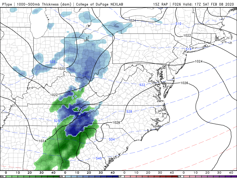
18z Rgem is out. Clobbers N. Ga. Also appears an hour or two faster with onset compared to other models. The below image is valid for 11am tomorrow.

-
1
-
-
at the risk of sounding too much like a weenie; i'm not buying the 33-35 surface temps for NE GA, upstate SC. All the models have temps around -4 to -6c at 850mb and -2 to -3c all the way down to 950mb. If it starts ripping snow with that profile, we're quickly dropping to 32/33, imo.
-
3
-
-
all the short range models are consistent with this event starting in North central GA around 9:30 or 10:00am. Starts for Oconee/Pickens in the western upstate around 11:00am. Seems like the short range models are all jack potting the area around lake Lanier to Gainesville to Gwinnettecounty with anywhere from .3 to .5 inches of liquid equivalent.
Modlels are showing any where from .05-.3 inches of liquid for the western upstate.
I feel very confident that the Cherokee county, GA/Lake Lanier/Gainesville/ Gwinnett area is going to get accumulations. Wouldn't be surprised if someone in this area gets close to 3 inches.
People above 1500' in Georgia are a virtual lock to get 1-3 inches unless the precip grossly under-performs.
-
4 minutes ago, WarmNose said:
RAP doesn’t like this one for Upstate SC. So for that reason, I’m out
RAP is always too warm at the surface at this range. furthermore, even it shows the freezing level only few hundred feet above the ground. All that precip would certainly be falling as snow. even if it doesn't have a chance to stick.
-
arw-2 looking juicy for Northern GA/western upstate!

-
A few graupel pellets falling in Clemson as well right now.
-
Timing doesn't look bad to me for the western upstate. Looks like flakes will start to fly around 10:00am. And we all know these events typically show up a few hours ahead of time. Ideal timing for the lake lanier area though, 8:00am-10:00am. Really starting to think they get a couple inches.
-
1
-
-
8 minutes ago, Buckfever2 said:
Can you post that NAM ?

-
12z 3km NAM absolutely jackpots the Lake Lanier area. Looks like 1-3 inches could fall there tomorrow morning. Somebody should start the thread??
-
34 minutes ago, lilj4425 said:
Yeah...for a cold rain.
Thermal profiles are all snow for the northern upstate. Boundary layer will make it difficult to stick. But if we get any appreciable precip I expect it to fall as snow tomorrow.
-
1
-
-
Looks like that lone super cell in Middle Georgia has some tight rotation. Why isn't there a warning on it?
-
Hi Res Nam says winter starts on Saturday for us Mack!
-
2
-
2/8/2020 Snow Event
in Southeastern States
Posted
Cornelia, GA temp has dropped from 34.5 to 29 with the snow!