

Burghblizz
-
Posts
1,742 -
Joined
-
Last visited
Content Type
Profiles
Blogs
Forums
American Weather
Media Demo
Store
Gallery
Everything posted by Burghblizz
-
 He isn’t a “Steeler fan”. Marty Griffin is a nut with an agenda on everything. He is the same guy that started the Cleveland rumor. In this case he is catering to the fools who just think the Gov was being “controlling”….so anything showing it’s “not that bad” fits his model.
 -
Lol - the Philly game you are referring to was about 6” during the game. The Pats/Oak playoff was about 3”.
-
Pittsburgh, Pa Winter 2023-24 Thread.
Burghblizz replied to meatwad's topic in Upstate New York/Pennsylvania
Snow Squall Warning for most of Butler and the western half of AGC right now. Imagine that will transition east. -
I think it’s the right call. But it could have been made a day ago.
-
What’s the most recent thinking as to where the heaviest bands will be at gametime?
-
Pittsburgh, Pa Winter 2023-24 Thread.
Burghblizz replied to meatwad's topic in Upstate New York/Pennsylvania
100% snow in Cranberry for the duration (just over the Butler county line) -
Pittsburgh, Pa Winter 2023-24 Thread.
Burghblizz replied to meatwad's topic in Upstate New York/Pennsylvania
Looks like a good batch about to hit over there. -
Pittsburgh, Pa Winter 2023-24 Thread.
Burghblizz replied to meatwad's topic in Upstate New York/Pennsylvania
About 2” here so far. HRRR had this backend hanging on more than what the radar appears, so we’ll see what happens. -
Pittsburgh, Pa Winter 2023-24 Thread.
Burghblizz replied to meatwad's topic in Upstate New York/Pennsylvania
I wasn’t worried about mix in SW Pa except for the 119 cooridor. Beautiful out right now - just a matter of cashing in on some of these rates with the backend racing in. -
Pittsburgh, Pa Winter 2023-24 Thread.
Burghblizz replied to meatwad's topic in Upstate New York/Pennsylvania
Had a Virga storm for awhile but it’s thumping now. -
Pittsburgh, Pa Winter 2023-24 Thread.
Burghblizz replied to meatwad's topic in Upstate New York/Pennsylvania
18Z NAM looks largely the same - maybe a tick stronger and cooler. Extreme SW PA does a little better this run. Maybe that will be enough to expand the adv.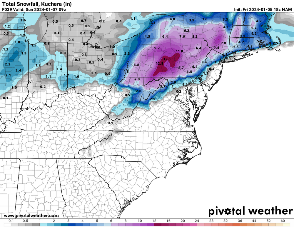
-
Pittsburgh, Pa Winter 2023-24 Thread.
Burghblizz replied to meatwad's topic in Upstate New York/Pennsylvania
Was about to claim victory for this since it popped up for me - but doesn’t look like they have one for AGC yet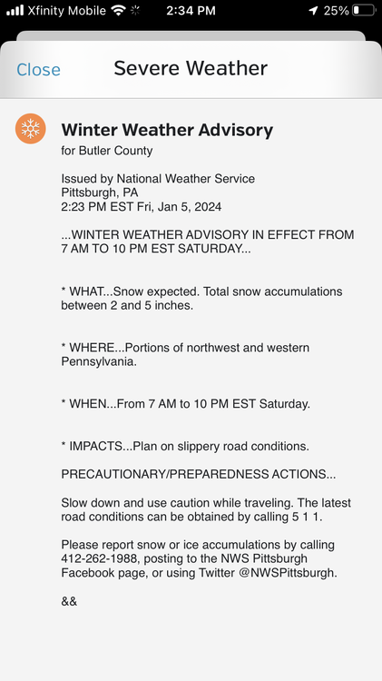
-
Pittsburgh, Pa Winter 2023-24 Thread.
Burghblizz replied to meatwad's topic in Upstate New York/Pennsylvania
Not even sure why I’m looking at this - but 12Z Euro takes next weekends monster storm and eliminates the severe cutting. Takes a primary into Ky/southern Oh, and then pops a secondary over DC. That look never seems to hold, but something to watch. -
Pittsburgh, Pa Winter 2023-24 Thread.
Burghblizz replied to meatwad's topic in Upstate New York/Pennsylvania
I’d go advisory 2”-5”. Bottom and top end are two different impacts, but you can package it into one forecast that makes you look good -
Pittsburgh, Pa Winter 2023-24 Thread.
Burghblizz replied to meatwad's topic in Upstate New York/Pennsylvania
Thanks! I’ve been holding out for the same reason. -
Pittsburgh, Pa Winter 2023-24 Thread.
Burghblizz replied to meatwad's topic in Upstate New York/Pennsylvania
They still could be right - but I think somewhere in the middle…. 2-4” from NW to SE is becoming a good bet. And like someone said - I’m also a big fan of rates (especially in the daytime). I’d be happy to get a couple hours of 1”+ in the middle of the day. -
Pittsburgh, Pa Winter 2023-24 Thread.
Burghblizz replied to meatwad's topic in Upstate New York/Pennsylvania
I think weather karma owes us a last minute NW tick for all the last minute NW ticks that provided slop. -
Pittsburgh, Pa Winter 2023-24 Thread.
Burghblizz replied to meatwad's topic in Upstate New York/Pennsylvania
With a gulf system that is also a quick hitter, I have a feeling the NAM is going to have a pretty good spread (higher) compared to other models. I’d say let’s not dream too much of that so we aren’t disappointed by what looks like could be a nice moderate snowfall. -
Pittsburgh, Pa Winter 2023-24 Thread.
Burghblizz replied to meatwad's topic in Upstate New York/Pennsylvania
Storm + game will be a fun day. The KC playoff loss in ‘21 was during a storm. (the 9” storm that isn’t remembered too fondly since it came in two parts, and a few areas fell short) Hoping this sets up to be a more positive day! -
Pittsburgh, Pa Winter 2023-24 Thread.
Burghblizz replied to meatwad's topic in Upstate New York/Pennsylvania
Nice to not just be relying on one model. NAM coming into range will be interesting. (If it sucks, we can say throw it aht it’s just the 84 hr NAM. If it’s good, it’s one more on board ) -
Pittsburgh, Pa Winter 2023-24 Thread.
Burghblizz replied to meatwad's topic in Upstate New York/Pennsylvania
They always overdo route 119 from Uniontown to near Latrobe. I can say with almost 100% certainty it isn’t snowing 4” in Uniontown. It might 10 miles away and 800’ higher - but it’s just not happening where the population centers are. -
Pittsburgh, Pa Winter 2023-24 Thread.
Burghblizz replied to meatwad's topic in Upstate New York/Pennsylvania
Interesting that they are trying to validate official readings through a car thermometer (I feel like mine always reads warm) And wow as far as 2023 total snowfall. That’s a 100 year type anomaly on the low side. And We very well could get shut out the rest of the way. -
Pittsburgh, Pa Winter 2023-24 Thread.
Burghblizz replied to meatwad's topic in Upstate New York/Pennsylvania
Hopefully we start seeing at least a little digital snow to make things interesting. Maybe a long shot on Sunday. -
Pittsburgh, Pa Winter 2023-24 Thread.
Burghblizz replied to meatwad's topic in Upstate New York/Pennsylvania
Clock’s officially ticking. Let’s go! -
Pittsburgh/Western PA Fall 2023 Discussion
Burghblizz replied to Ahoff's topic in Upstate New York/Pennsylvania
Was driving on the parkway north between Wexford and Warrendale and it was POUNDING. Roads mostly just wet, but visibility was briefly near zero


