CaryWx
-
Posts
2,832 -
Joined
-
Last visited
Content Type
Profiles
Blogs
Forums
American Weather
Media Demo
Store
Gallery
Everything posted by CaryWx
-
Hang on folks...
-
Some Sibir` cold coming in
-
-

1/10-11 super awesome winter SE OBS thread
CaryWx replied to strongwxnc's topic in Southeastern States
Think I just switched to zr -
4:45pm vs 5:15 pm below. Flipping to snow
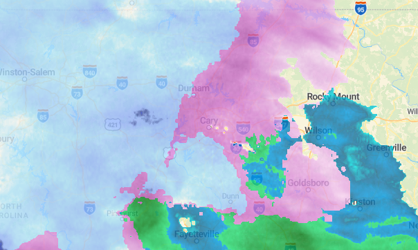
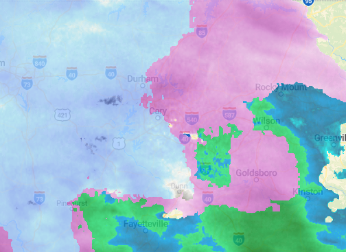
-
I have a mix of snow and sleet. Predominantly sleet though
-
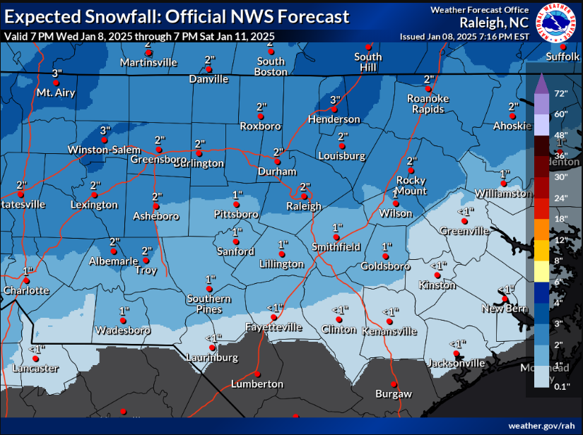
It's tightening though too Brick. Notice the very southern portion has shrunken (disappeared) over Johnston and Harnett counties from previous run edit: It is also lining up more with RAP except for totals so that's good
-
It's an A looks like....from NWS RAH The surface low should continue ewd along the FL panhandle for the next couple hours, then lift newd through FL/GA before tracking along the Carolina coast tonight. As the low approaches, the warm nose aloft will strengthen, especially in the southeast. The low should begin to move enewd away from the NC coast Sat morning.
-
Are these RAP and HRRR models showing only snow or is it sn/ip/zr all together?
-
Light flurries in Cary
-
Would also think the 925 has to be trailing unless this scours down vertically quickly.
-
Depending on how fast/slow this migrates north can make significant difference in snow accumulation I would think
-
You mean the 850??
-
Are we predicted to begin that early? With column saturation would think 6-pm
-
You and me both. The airport could end up with twice as much snow as my location.
-
Interesting. I have this one as of 3:16pm
-
What model is that? Seems a bit agressive
-
You're shaping up to be in a good spot
-
Going to be more NWS county activations at 4pm I believe
-
That run leaves my back yard with a Bluto Blutarsky grade point average
-
"...radar hallucinations"? You mean the pink elephant echoes
-
At least >40yrs that I know of. The Raleigh News and Observer did an article on it around 1980 that I recall.
-
Need to be 0c at 925mb don't we
-
If we take a blend of the euro and gfs runs not a bad place to be.