CaryWx
-
Posts
2,832 -
Joined
-
Last visited
Content Type
Profiles
Blogs
Forums
American Weather
Media Demo
Store
Gallery
Everything posted by CaryWx
-

February 19-20 Major Winter Storm Threat
CaryWx replied to NorthHillsWx's topic in Southeastern States
From WRAL...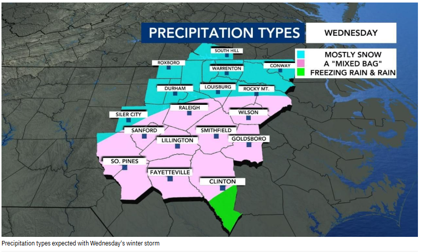
-
February 19-20 Major Winter Storm Threat
CaryWx replied to NorthHillsWx's topic in Southeastern States
Ice as in zr? -
February 19-20 Major Winter Storm Threat
CaryWx replied to NorthHillsWx's topic in Southeastern States
check the latest gefs numbers out there -
February 19-20 Major Winter Storm Threat
CaryWx replied to NorthHillsWx's topic in Southeastern States
I'm not seeing that across the models. Even the nam had a better cold press this last run -
February 19-20 Major Winter Storm Threat
CaryWx replied to NorthHillsWx's topic in Southeastern States
getting buried maybe -
February 19-20 Major Winter Storm Threat
CaryWx replied to NorthHillsWx's topic in Southeastern States
took slp more off the coast this run -
February 19-20 Major Winter Storm Threat
CaryWx replied to NorthHillsWx's topic in Southeastern States
That's fairly tolerable albeit some power hits. -
I'll buy that... but better bet is mixy sleet storm or cold rain
-
The broad field depictions are suspect for sure
-
I don't have specifics but I've seen charts posted where it is rated pretty well. You are correct in 'what are the specifics it scores well in?' and at what range (which I mentioned here) No, I do not see a suppressed track verifying. I do suspect a further north (Va) centralized placement with this storm. Just been the case this season. All anecdotal thinking for sure, but wouldn't surprise me in the end.
-
I thought it had good verification scores. This would be range dependent though. 3-5days?
-
No 12z euro run for you!... Come back. 6hrs.
-
Wouldn't surprise me. This would be overrunning I believe.
-
-
zr
-
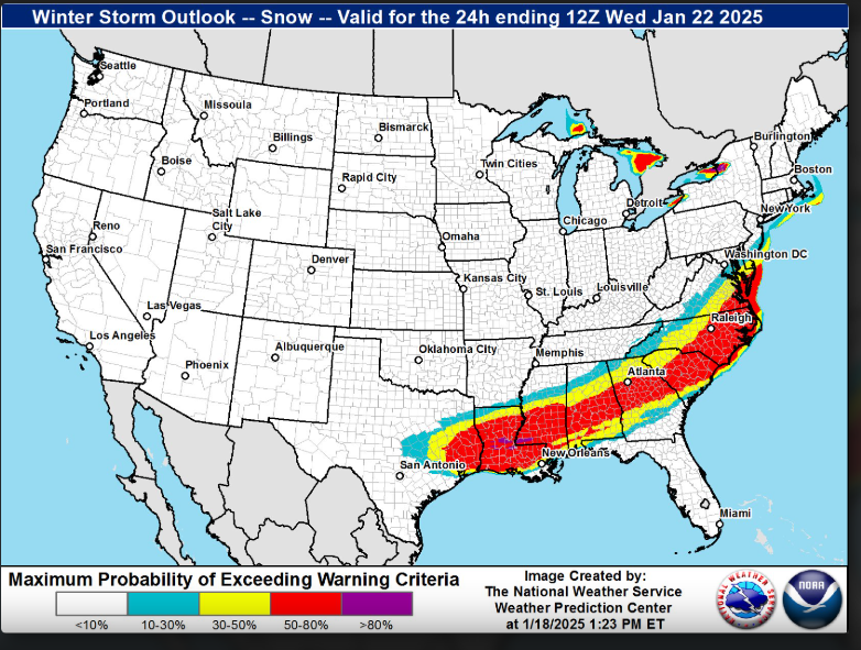
If this verifies RAH will need to add Lee & Harnett counties as WSW
-
Not sure it will be 5" snow in Triangle if your ne-->sw line includes that
-
Is that assuming 10:1 ratios only?
-
For NC folks west of I95 it all depends on where the FGEN sets up for best precip rates
-
WRAL playing this down on the evening report
-
yes
-
For NC nice jump NW
-
Glad to see you get a WSW. Sure it wasn't even in your thinking a couple weeks ago.
-
A word to the wise--Don't take snow/ice totals too seriously at 84hrs on the NAM
-
From the real mccoys