


NEGa
-
Posts
2,566 -
Joined
-
Last visited
Content Type
Profiles
Blogs
Forums
American Weather
Media Demo
Store
Gallery
Everything posted by NEGa
-
A lot have more to the obs thread since it’s nowcasting and happening now
-
Wow that is amazing lol. I just wish the wedge would start building down so we can see at least something frozen
-
I noticed that too - a huge discrepancy in elevation in their cwa. They usually separate out into several different, more specific language though. I have never seen them that combined (at least that I can remember). I do find it odd how their warning language does not really seem to match their accumulation maps
-
The forecasts and models are all over the place. Warnings have gone out but point and click has no accumulation. CAD fo my area, at least is usually freezing rain or sleet, rarely snow. Not surprised but was hoping to get some heavy snow here - an inch of ice is quite a lot lol
-
I am definitely liking how it looks better this morning, but being on the edge, especially the southern edge, always makes me nervous lol. it is early December so expectations are tempered (but excitement over the possibilities the models are showing is not tempered). I have seen it 31 and raining so hard it just never really gets a glaze going. at least it looks like the chances of the higher ice accumulations are down. I love a good ice storm but like to keep my power on
-
its hard for here as well since its such a close call. I am hoping the slightly south trends mean the CAD will be coming in a little stronger. However, historically for NE GA, at least, CAD events are ice ice baby. Sometimes a front end thump of snow but usually ice (since I am apparently one of the "odd ones" who enjoys all winter wx a good ice storm doesn't really bother me). my issue with a good glaze is more how heavy the precipitation is. if its too heavy and not into the 20s it might not really ice over all that much
-
I can’t believe I woke up and the storm is still showing up - even more so that there is still quite a bit of consistency lol. The thing that strikes me for ne ga and the upstate, st least, is the snow amounts with a CAD. We may get a front end thump of snow but for the most part CADs here are not deep enough for snow but mostly ice. Even if we do get snow most big storms of this set up usually mix with or change to sleet then freezing rain. If the “second” shot moves through as snow on top of ice that would be a sight to see for sure
-
I’ve learned over the years to not too excited too far out. Sunday and Monday runs were interesting - now with the consistency and getting closer it’s hard not to start getting pumped up a bit lol. So far things are looking interesting for ne ga - if we can get some of the lower dewpoints in we could be in business. Side note - after 70 Sunday and a warm Monday currently it’s 35 lol
-
Yes I am here and have been reading, just not much to add yet lol. I just saw the maps wow is all I can say. Normally I would be giving a chance this early a big no go, but after last years (I think dec 8 or 9?) big early snow I guess it can happen. I have seen too many of these end in disaster as we get closer (although so far so good) so I am just sort of watching and waiting. I will say that one concern is the huge amount of QPF in that if we end up with more ice over snow, if it is coming down hard enough it would be less likely to accumulate and/or latent heat release would raise the temp just above freezing. Some of the amounts showing up are just outrageous and I have a hard time believing it. Of course even half or a fraction would be a good dumping
-
I noticed that too - a big difference on ne ga and upstate rainfall totals right now. its hard to know which one to believe lol
-
Ah, thanks. Trying to keep up on the latest while I am at work
-
Am I misreading the latest update? I was under the assumption this storm (for NE GA, the Upstate and Western NC) was for like late Sunday or Monday. I guess I did not realize the storm would be starting earlier?
-
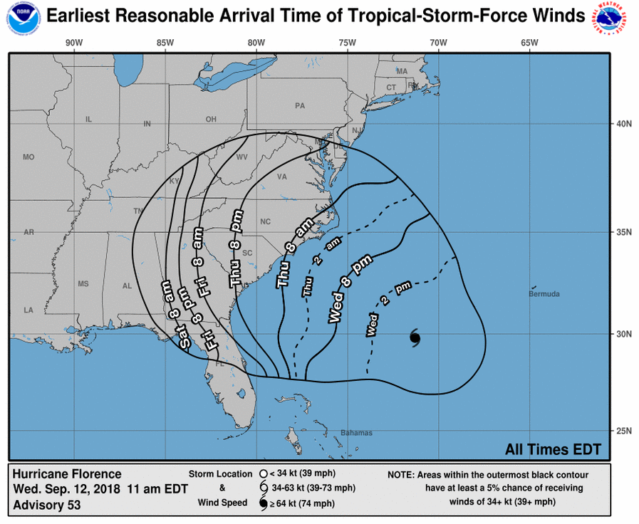
thats for sure. we had some rain over the weekend ,but its been pretty dry here too lately (although through July it seemed to be raining every day). what is even more interesting in the track is the storm moving sw over the Gulf Stream. if I recall, many storms (hurricanes and noreasters) get a little nudge to the north as they approach the coast. to have it move sw over the gulf stream seems a bit odd
-
Well this new track was weird to wake up lol. I thought Irma was a one time deal - if this were to happen again a year later I would be flabbergasted. Since it’s 5 days out I hope the track shifts again. I love wild wx but Irma did a lot of damage around here and I had no power for 5 or 6 days. The aftermath clean up was not fun lol
-

The December to Remember 7th-8th blue turd winter threat thread.
NEGa replied to lilj4425's topic in Southeastern States
Ok thanks. Maybe it just started here. Took the dogs out and it’s wet but it’s sleeting here now -
The December to Remember 7th-8th blue turd winter threat thread.
NEGa replied to lilj4425's topic in Southeastern States
Is it snowing in Gainesville? Just woke up to rain here lol. -
Ditto to big frosty. Love any Frozen precip. Heavy snow and coating of ice is fine by me. I enjoyed Monday/tues ice storm
-
Is this this fix to stop all the HTML tags or to increase speed the pages load? Using mobile skin it works great, the only issue i have had are the extra tags (which is fine as long as i can post and reply lol)
-
Is this this fix to stop all the HTML tags or to increase speed the pages load? Using mobile skin it works great, the only issue i have had are the extra tags (which is fine as long as i can post and reply lol)
-
I am checking from an iPad...wasn't able to get on yesterday but it seems to be working fine now (Saturday morning)
