buckeyefan1
-
Posts
13,470 -
Joined
Content Type
Profiles
Blogs
Forums
American Weather
Media Demo
Store
Gallery
Everything posted by buckeyefan1
-

The “I bring the mojo” Jan 30-Feb 1 potential winter storm
buckeyefan1 replied to lilj4425's topic in Southeastern States
Still going -
The “I bring the mojo” Jan 30-Feb 1 potential winter storm
buckeyefan1 replied to lilj4425's topic in Southeastern States
27:1 is the highest I've ever seen here GSP 18z GFS 260131/0400Z 46 04008KT 31.5F SNOW 7:1| 0.1|| 0.00|| 0.00|| 0.012 7:1| 0.1|| 0.00|| 0.00|| 0.01 100| 0| 0 260131/0500Z 47 04008KT 30.8F SNOW 10:1| 0.2|| 0.00|| 0.00|| 0.020 9:1| 0.3|| 0.00|| 0.00|| 0.03 100| 0| 0 260131/0600Z 48 04008KT 30.3F SNOW 8:1| 0.1|| 0.00|| 0.00|| 0.019 8:1| 0.4|| 0.00|| 0.00|| 0.05 100| 0| 0 ----------------------------------------------+----++-----+-------------++--------------++-------------++-----------+---+--- 260131/0700Z 49 04009KT 29.7F SNOW 12:1| 0.2|| 0.00|| 0.00|| 0.014 9:1| 0.6|| 0.00|| 0.00|| 0.07 100| 0| 0 260131/0800Z 50 04009KT 28.7F SNOW 10:1| 0.1|| 0.00|| 0.00|| 0.010 9:1| 0.7|| 0.00|| 0.00|| 0.08 100| 0| 0 260131/0900Z 51 04009KT 28.1F SNOW 12:1| 0.2|| 0.00|| 0.00|| 0.016 10:1| 0.9|| 0.00|| 0.00|| 0.09 100| 0| 0 260131/1000Z 52 04009KT 27.4F SNOW 13:1| 0.3|| 0.00|| 0.00|| 0.022 10:1| 1.2|| 0.00|| 0.00|| 0.11 100| 0| 0 260131/1100Z 53 04009KT 26.5F SNOW 15:1| 0.4|| 0.00|| 0.00|| 0.025 11:1| 1.5|| 0.00|| 0.00|| 0.14 100| 0| 0 260131/1200Z 54 04009KT 26.1F SNOW 19:1| 0.5|| 0.00|| 0.00|| 0.024 12:1| 2.0|| 0.00|| 0.00|| 0.16 100| 0| 0 ----------------------------------------------+----++-----+-------------++--------------++-------------++-----------+---+--- 260131/1300Z 55 04010KT 25.8F SNOW 20:1| 0.4|| 0.00|| 0.00|| 0.021 13:1| 2.4|| 0.00|| 0.00|| 0.18 100| 0| 0 260131/1400Z 56 04011KT 25.6F SNOW 23:1| 0.5|| 0.00|| 0.00|| 0.020 14:1| 2.9|| 0.00|| 0.00|| 0.20 100| 0| 0 260131/1500Z 57 04012KT 25.1F SNOW 23:1| 0.5|| 0.00|| 0.00|| 0.024 15:1| 3.4|| 0.00|| 0.00|| 0.23 100| 0| 0 260131/1600Z 58 04012KT 25.2F SNOW 25:1| 0.6|| 0.00|| 0.00|| 0.025 16:1| 4.0|| 0.00|| 0.00|| 0.25 100| 0| 0 260131/1700Z 59 04011KT 25.4F SNOW 27:1| 0.7|| 0.00|| 0.00|| 0.024 17:1| 4.7|| 0.00|| 0.00|| 0.28 100| 0| 0 260131/1800Z 60 04011KT 25.6F SNOW 27:1| 0.7|| 0.00|| 0.00|| 0.026 18:1| 5.4|| 0.00|| 0.00|| 0.30 100| 0| 0 ----------------------------------------------+----++-----+-------------++--------------++-------------++-----------+---+--- 260131/1900Z 61 03011KT 26.5F SNOW 24:1| 0.6|| 0.00|| 0.00|| 0.026 18:1| 6.0|| 0.00|| 0.00|| 0.33 100| 0| 0 260131/2000Z 62 36011KT 25.2F SNOW 23:1| 0.8|| 0.00|| 0.00|| 0.033 19:1| 6.8|| 0.00|| 0.00|| 0.36 100| 0| 0 260131/2100Z 63 34012KT 22.7F SNOW 23:1| 0.6|| 0.00|| 0.00|| 0.025 19:1| 7.4|| 0.00|| 0.00|| 0.39 100| 0| 0 260131/2200Z 64 34015KT 21.1F SNOW 15:1| 0.2|| 0.00|| 0.00|| 0.015 19:1| 7.6|| 0.00|| 0.00|| 0.40 100| 0| 0 260131/2300Z 65 34018KT 20.0F SNOW 18:1| 0.1|| 0.00|| 0.00|| 0.008 19:1| 7.7|| 0.00|| 0.00|| 0.41 100| 0| 0 -
The “I bring the mojo” Jan 30-Feb 1 potential winter storm
buckeyefan1 replied to lilj4425's topic in Southeastern States
He's still checking in and posting when he can, although it's early in the day due to where he is on the other side of the globe. He dropped in yesterday for a bit We all miss his BOOM! -
The “I bring the mojo” Jan 30-Feb 1 potential winter storm
buckeyefan1 replied to lilj4425's topic in Southeastern States
Yep! Lived in the carmel commons area and she owned the cookie store there. Everyone sliding around and stopping mid hill then sliding backwards had me cracking up. Spent the morning pulling peeps out of ditches Good times -
The “I bring the mojo” Jan 30-Feb 1 potential winter storm
buckeyefan1 replied to lilj4425's topic in Southeastern States
You're not far off there 5' 1" and 105lbs so once those winds reach warning criteria, I need cinder blocks for shoes -
The “I bring the mojo” Jan 30-Feb 1 potential winter storm
buckeyefan1 replied to lilj4425's topic in Southeastern States
These ratios 260131/1200Z 42 04010KT 28.3F SNOW 16:1| 0.2|| 0.00|| 0.00|| 0.015 16:1| 0.2|| 0.00|| 0.00|| 0.01 100| 0| 0 ----------------------------------------------+----++-----+-------------++--------------++-------------++-----------+---+--- 260131/1300Z 43 04010KT 27.0F SNOW 23:1| 0.7|| 0.00|| 0.00|| 0.029 21:1| 0.9|| 0.00|| 0.00|| 0.04 100| 0| 0 260131/1400Z 44 03011KT 26.9F SNOW 24:1| 0.7|| 0.00|| 0.00|| 0.028 22:1| 1.6|| 0.00|| 0.00|| 0.07 100| 0| 0 260131/1500Z 45 03011KT 26.5F SNOW 25:1| 0.7|| 0.00|| 0.00|| 0.028 23:1| 2.3|| 0.00|| 0.00|| 0.10 100| 0| 0 260131/1600Z 46 02010KT 26.1F SNOW 24:1| 0.5|| 0.00|| 0.00|| 0.022 23:1| 2.8|| 0.00|| 0.00|| 0.12 100| 0| 0 260131/1700Z 47 01010KT 25.8F SNOW 22:1| 0.9|| 0.00|| 0.00|| 0.039 23:1| 3.7|| 0.00|| 0.00|| 0.16 100| 0| 0 260131/1800Z 48 36010KT 25.4F SNOW 16:1| 0.8|| 0.00|| 0.00|| 0.049 21:1| 4.4|| 0.00|| 0.00|| 0.21 100| 0| 0 ----------------------------------------------+----++-----+-------------++--------------++-------------++-----------+---+--- 260131/1900Z 49 35011KT 25.1F SNOW 13:1| 0.5|| 0.00|| 0.00|| 0.036 20:1| 4.9|| 0.00|| 0.00|| 0.24 100| 0| 0 260131/2000Z 50 35011KT 24.3F SNOW 12:1| 0.1|| 0.00|| 0.00|| 0.012 20:1| 5.0|| 0.00|| 0.00|| 0.26 100| 0| 0 260131/2100Z 51 35010KT 24.3F SNOW 14:1| 0.1|| 0.00|| 0.00|| 0.004 19:1| 5.1|| 0.00|| 0.00|| 0.26 100| 0| 0 -
The “I bring the mojo” Jan 30-Feb 1 potential winter storm
buckeyefan1 replied to lilj4425's topic in Southeastern States
When I first moved here in 87/88 I was in charlotte and they got 12" of snow. I drove my Mom to work at the mall and had to go back for her because everything closed down and stayed that way for a week -
It took the low away from the Bahamas and didn’t know what to do after that. It doesn’t even agree with its own kinfolk bless it
-
It tries so hard though Bless its heart
-
The “I bring the mojo” Jan 30-Feb 1 potential winter storm
buckeyefan1 replied to lilj4425's topic in Southeastern States
Ya’ll, I absolutely love when GSP talks like this There has also been a signal for a "dry slot" between snow bands in the general vicinity of northeast Georgia, although where this occurs is still uncertain - but even there warning criteria snow should still be realized. The ceiling is high with this event and a swath of 8-12"+ totals cannot be ruled out where the greatest banding is able to set up shop. -
The “I bring the mojo” Jan 30-Feb 1 potential winter storm
buckeyefan1 replied to lilj4425's topic in Southeastern States
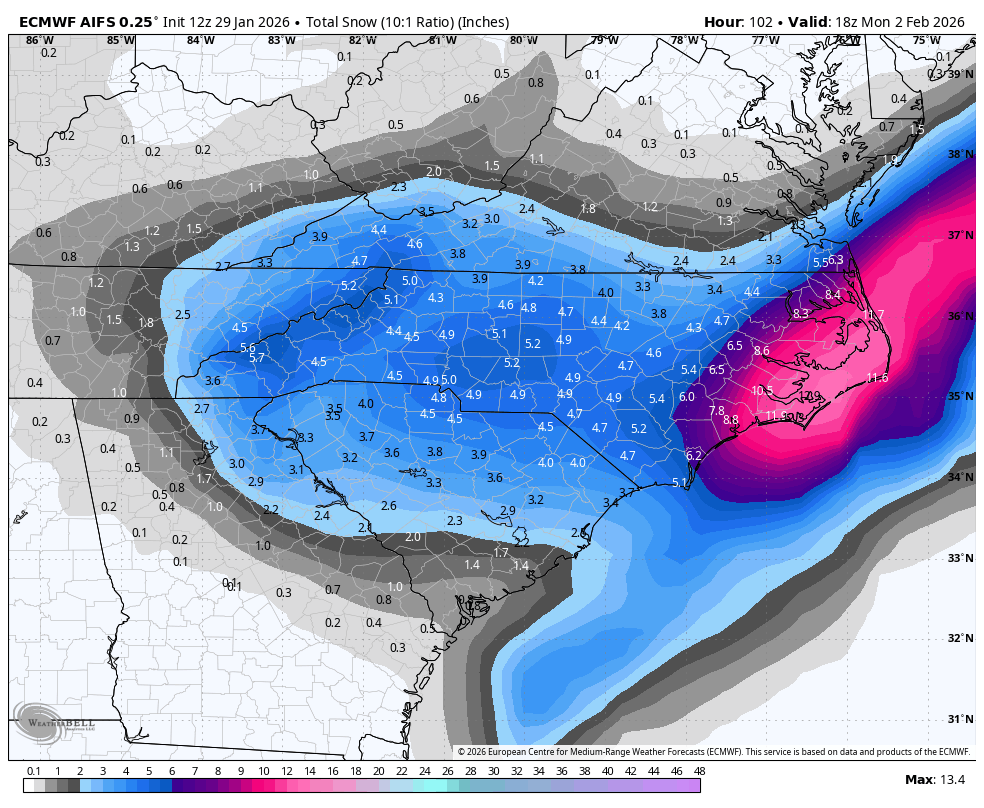
Here’s the Euro AI map for those who were stroking out to see it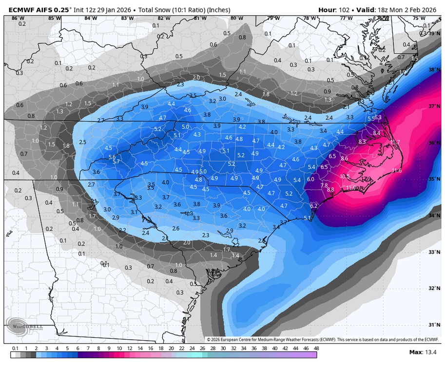
-
Ya’ll, it sure doesn’t take much precip to get great totals with these ratios. When mby got 9” back in ‘10 it was only the equivalent of about .27 I loved that storm
-
The “I bring the mojo” Jan 30-Feb 1 potential winter storm
buckeyefan1 replied to lilj4425's topic in Southeastern States
Stop using the mobile version and use the desktop -
The “I bring the mojo” Jan 30-Feb 1 potential winter storm
buckeyefan1 replied to lilj4425's topic in Southeastern States
Turn your phone sideways. Landscape. You’ll see locations -
The “I bring the mojo” Jan 30-Feb 1 potential winter storm
buckeyefan1 replied to lilj4425's topic in Southeastern States
Ya’ll, PLEASE take your cliff diving to the appropriate thread. Thank you -
The “I bring the mojo” Jan 30-Feb 1 potential winter storm
buckeyefan1 replied to lilj4425's topic in Southeastern States
That’s a nice way to put it -
2025-2026 Fall/Winter Mountain Thread
buckeyefan1 replied to Buckethead's topic in Southeastern States
That’s absolutely beautiful -
The “I bring the mojo” Jan 30-Feb 1 potential winter storm
buckeyefan1 replied to lilj4425's topic in Southeastern States
-
The “I bring the mojo” Jan 30-Feb 1 potential winter storm
buckeyefan1 replied to lilj4425's topic in Southeastern States
I believe he would double dog dare you to beat it Yasssssss it is One of our last conversations was how he was going to send a forum wide storm to remember -
The “I bring the mojo” Jan 30-Feb 1 potential winter storm
buckeyefan1 replied to lilj4425's topic in Southeastern States
Ya’ll should exhale, drop your shoulders, get your tongue off the top of your mouth, unclench your jaws and breathe You can hear a pin drop in here -
The “I bring the mojo” Jan 30-Feb 1 potential winter storm
buckeyefan1 replied to lilj4425's topic in Southeastern States
The key is the placement of the 50/50 -
2025-2026 Fall/Winter Mountain Thread
buckeyefan1 replied to Buckethead's topic in Southeastern States
One of these days I’ll be in the bullseye too -
This was rude from Chris Justus
-
2025-2026 Fall/Winter Mountain Thread
buckeyefan1 replied to Buckethead's topic in Southeastern States
We all know that if social media puts it out there, it must be true -
Because it’s only an app. It can’t hold all the information. It changes several times a day. It’s great for watching radar, but never ever use an app to make your plans regarding the weather.