buckeyefan1
-
Posts
13,470 -
Joined
Content Type
Profiles
Blogs
Forums
American Weather
Media Demo
Store
Gallery
Everything posted by buckeyefan1
-
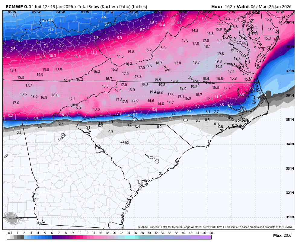
I forgot what beautiful colors there are in meteograms
-
This is from the 12z Euro Ens for mby
-

2025-2026 Fall/Winter Mountain Thread
buckeyefan1 replied to Buckethead's topic in Southeastern States
Don't judge This will be my first, see the whites of its eyes, well above warning criteria winter system here in the upstate and no, I don't count 22 when I was in Fountain Inn -
2025-2026 Fall/Winter Mountain Thread
buckeyefan1 replied to Buckethead's topic in Southeastern States
You know you're a when you start giggling like a crazy person as you check each layer of the atmosphere, and see everything solidly below freezing -
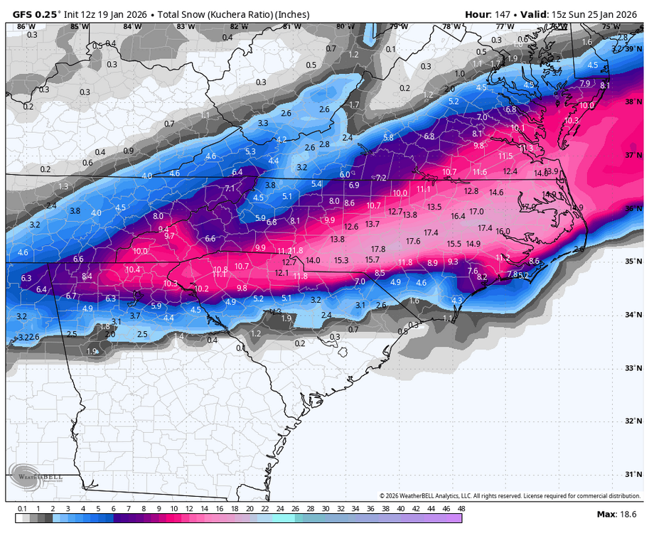
18z gfs
-
2025-2026 Fall/Winter Mountain Thread
buckeyefan1 replied to Buckethead's topic in Southeastern States
Maggie Steve is right. It’s too early to say how stacked the cold air will be. All the players have been there for a while now so the devil is in the details as they say, so stay tuned -
It’s been posted already
-
2025-2026 Fall/Winter Mountain Thread
buckeyefan1 replied to Buckethead's topic in Southeastern States
You spelled the entire southeast wrong -
Awfully generous with 6 I’ll the under
-
2025-2026 Fall/Winter Mountain Thread
buckeyefan1 replied to Buckethead's topic in Southeastern States
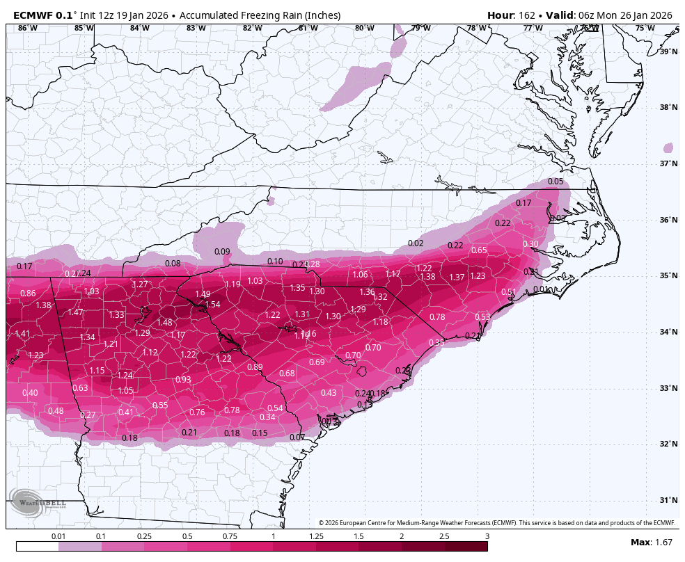
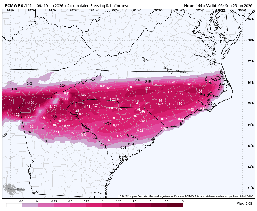
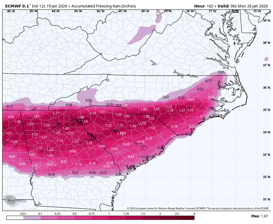
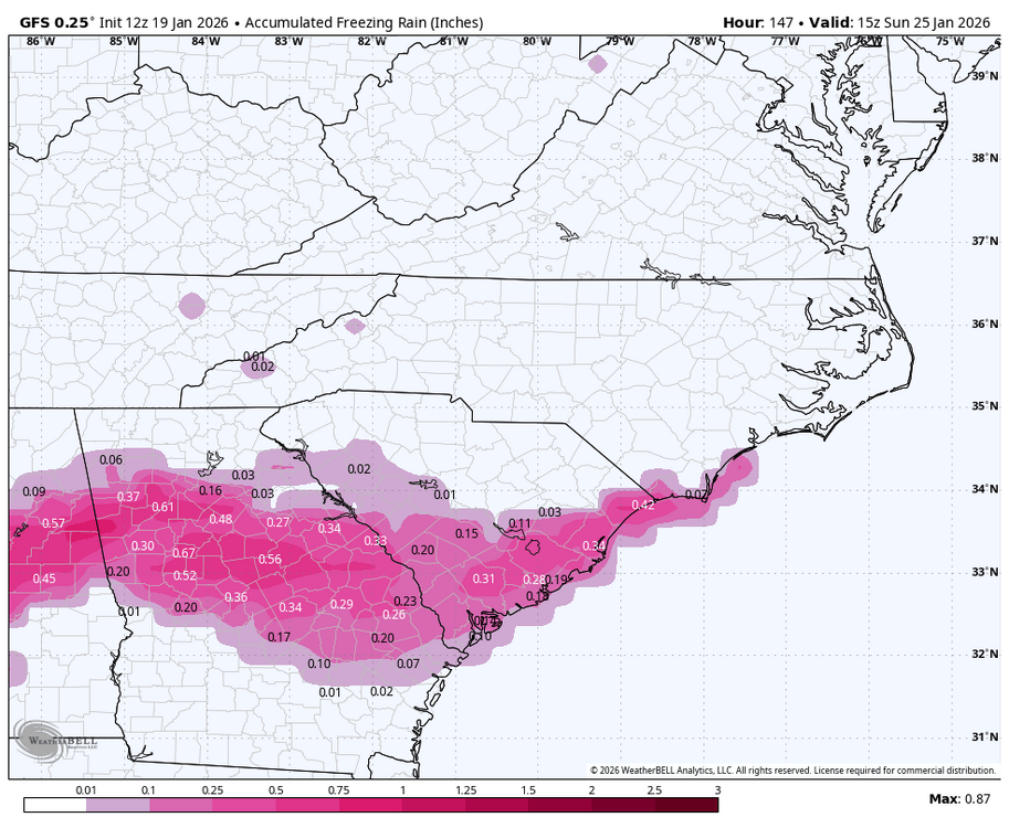
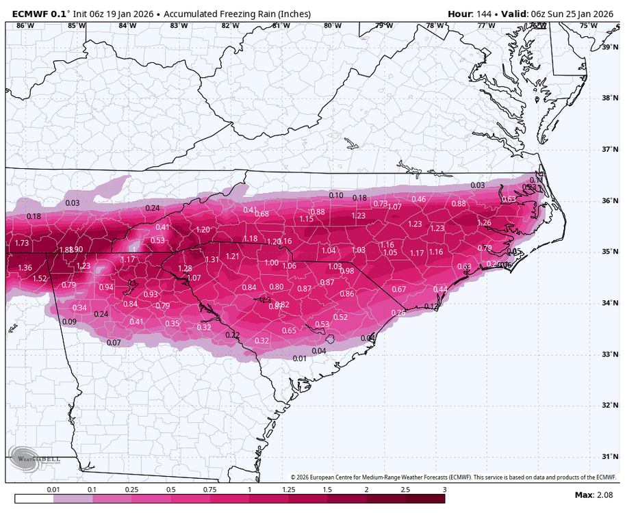
I sure hope that’s mostly ip/sn for me because that’s a shit ton of moisture incoming -
-
Bless its gfs heart
-
That’s my thought as well and I hope I’m thinking too warm
-
Yasssssss!!! It’s been soooooo long since we’ve needed this thread!! Let’s gooooooo!!!
-
Ya’ll, it’s now pinned. Could someone PLEASE start a sanitarium thread for one liners, complaints, etc so we can keep this thread clean for information? Also, could ya’ll put locations and for those lurking, please keep in mind where that poster is located.
-
You are correct. That will happen for a lot of people. He’s right too. Enough of a cold press will change the zr to ip or sn to help offset the destruction.
-
This gives me serious 02 flashbacks and they’re not pretty
-
-

-
This. It’s going to be an ice storm for someone. No sugar coating it.
-
2025-2026 Fall/Winter Mountain Thread
buckeyefan1 replied to Buckethead's topic in Southeastern States
-
I had Augusta/Aiken/Columbia flashbacks of destruction watching that run
-
2025-2026 Fall/Winter Mountain Thread
buckeyefan1 replied to Buckethead's topic in Southeastern States
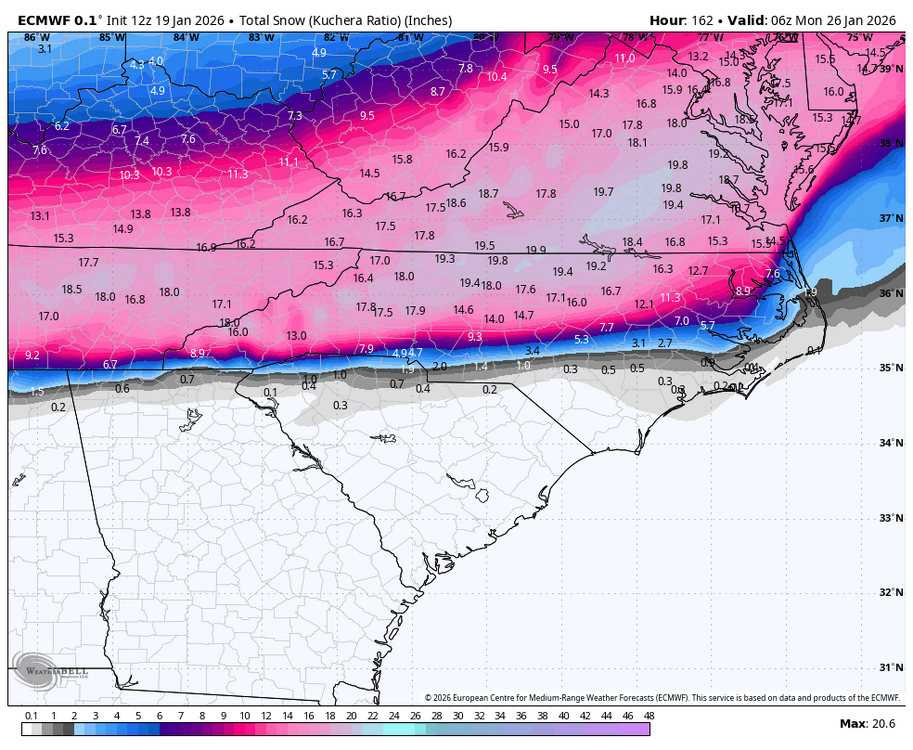
18z gfs as we wait for the king -
What suppression
-
As depicted that's not washing away. That's a low/mid 20 deg catastrophic ice storm