buckeyefan1
-
Posts
13,470 -
Joined
Content Type
Profiles
Blogs
Forums
American Weather
Media Demo
Store
Gallery
Everything posted by buckeyefan1
-

2025-2026 Fall/Winter Mountain Thread
buckeyefan1 replied to Buckethead's topic in Southeastern States

-
If she can come earlier, the better it will be. All travel will be backing up as it starts to our west
-
2025-2026 Fall/Winter Mountain Thread
buckeyefan1 replied to Buckethead's topic in Southeastern States
Just gonna drop this in here as well -
Indeed! You all have got your work cut out and I’ll be sending positive thoughts to ya I still expect to see swings until at least tomorrow afternoon and the teeeeeniest adjustment will have major impacts down the line. Buckle up everyone
-
I believe it will happen soon my friend PS…. Still wouldn’t rather go through the ups and downs of our nerdy obsession with weather with any other peeps or in any other place
-
I’m always hoping that everything trends colder as we get closer to game time
-
I wasn’t joking when I said that I had 02 flashbacks after that first insane run. That unfortunately hasn’t changed much for what I’m expecting for MBY, but I do believe that the sleet potential will be much higher than what is currently shown for a lot of people
-
I didn’t think it started until the 6z and fully by 12z. My brain is running on 2 hours of sleep and I just got back from my cae round trips and clocking into work so I’m not totally sure
-
Indeed I'm absolutely positive he's laughing his ass off at the mood swings as he reminisces about having winter storm warnings in one room and an advisory in another so no matter what any met said, it would always verify in his house and something about seeing the whites of its eyes before getting excited
-
2025-2026 Fall/Winter Mountain Thread
buckeyefan1 replied to Buckethead's topic in Southeastern States
I think his map is a pretty safe one as a first call. Easy enough to fine tune with the model chaos and before everyone gets nam'd and before recon data. -
Why are you trying to spoil all of the cliff diving
-
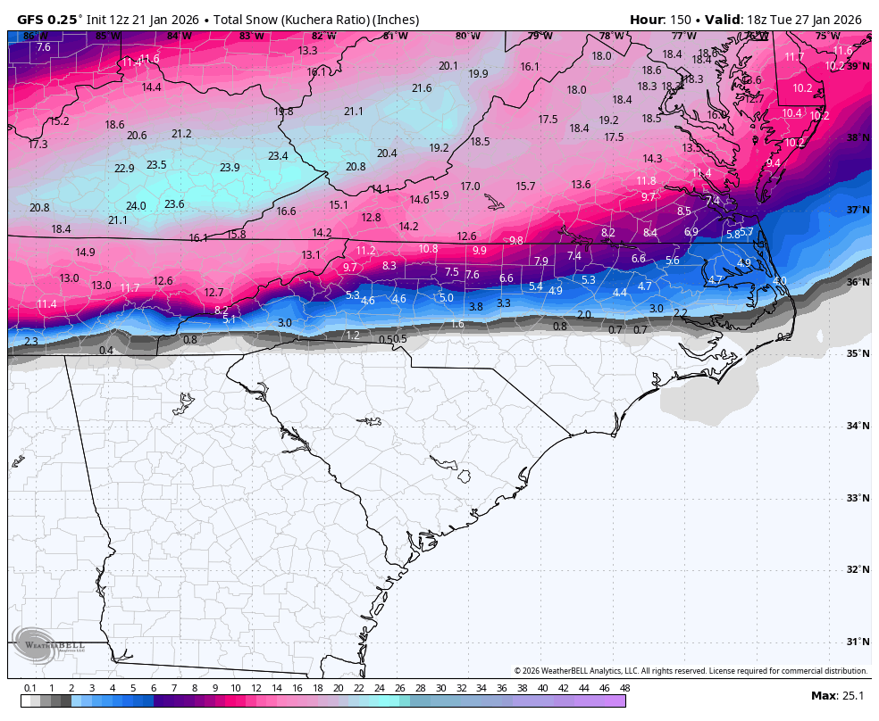
It's a ginormous sleet bomb for a lot of folks Those clown maps are horrible. There's 3 days to go and the mood swings as each model runs have been just as epic and horrible. I'm going to repeat myself and say this will be a high impact event for a lot of people. There will be snow. There will be sleet. There will be freezing rain. Where any of this will fall, or for how long, or for how many different times, or for how many different variations of winter at the same time will hit mby, yby, your neighbors backyard, etc is anyone's guess. It's what we do as nerds. Dissect every run. Ya'll aren't dissecting, you're whining. So buckle up buttercup and store all of it in your memory, because the ride is about to hit warp speed as it comes into hi res view
-
Ya'll live and die in here with each run. There's a thread for this, please use it for your cliff diving
-
This place always makes me giggle
-
18z euro
-
Ya'll, I'm having too much fun checking all the beautiful layers as this unfolds mby will be a frozen tundra of the best sledding kind according to the gfs I highly recommend 10/10
-
Stop. Final warning.
-
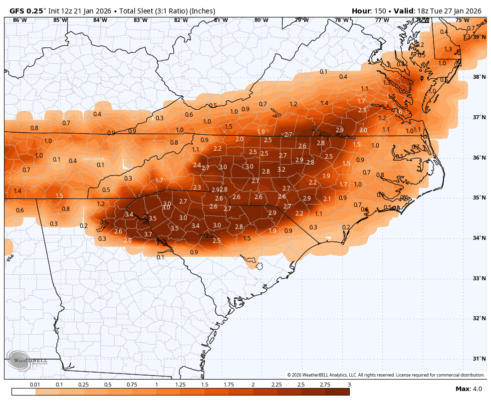
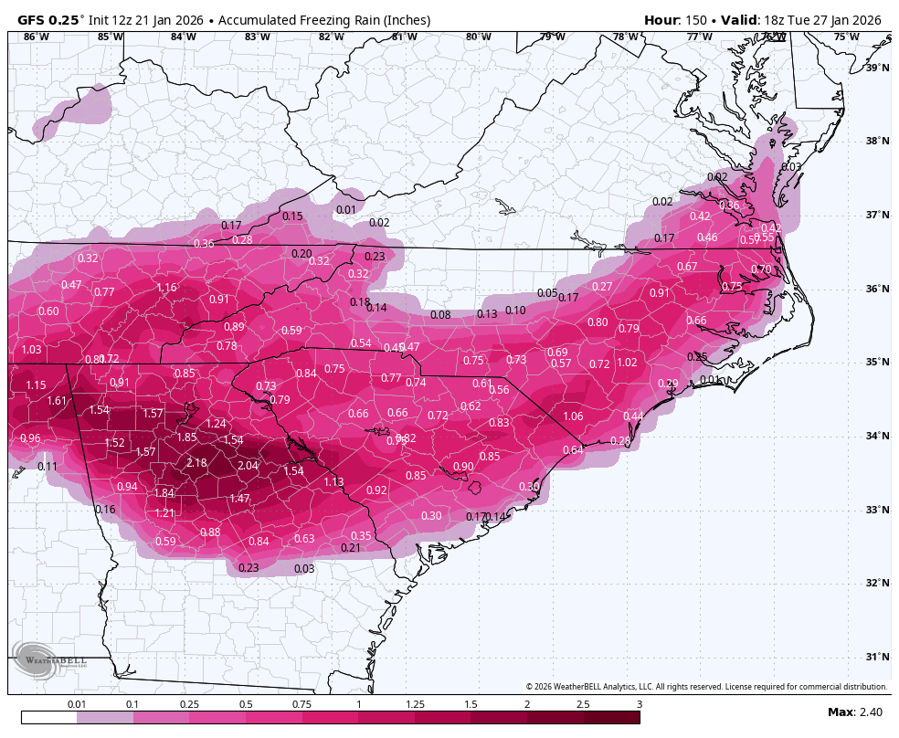
Here's the IP and ZR
-
-
2025-2026 Fall/Winter Mountain Thread
buckeyefan1 replied to Buckethead's topic in Southeastern States
+1 -
I went out until 0z Tuesday
-
Just your typical weenie walking the edges of the cliff as they live and die on every model run madness
-
I love it when you step out of your comfort zone for early calls
-
Yes as stated above plus we’re going to have recon data being included so be prepared for the madness that will follow
-
Best sledding ever