pasnownut
-
Posts
9,002 -
Joined
-
Last visited
Content Type
Profiles
Blogs
Forums
American Weather
Media Demo
Store
Gallery
Everything posted by pasnownut
-
0z GFS backed off on qpf distribution and is reflected on all important snow panels. 700's/850's were a tick better (to my eye). Little less warm intrusion, but still not quite enough for LSV. Hoping bias comes into play and it cools as we get closer. Just speaking verbatim and not pooh poohin by any means. Anxious to see what the Euro shares overnight. Still looking forward to seeing first flakes for the season (as well as tomorrow's runs). Poconos wins on this run. Night all.
-
0z NAM now rolling in and has backed of a bit on happy hour totals but still has us solidly in the game. 700's look better for SE PA and would indicate a little colder column to support sleet IR and less rain. If this trend continues, it wouldnt surprise to see totals bump down here.
-
DO NOT LOOK AT 18z NAM SNOW MAP...... JUST DONT TEASE YOURSELF. I have to say i'm a little surprised at some of the numbers I'm seeing. Just worried the the middle part that is taint...even to WSPT knocks back/out some of the numbers being spit out. Ya'll know me well enough to know that i want it more than many. If midlevels continue to trend cooler and warm nose gets further supressed as the HP is showing some staying power on recent runs for front end as alluded to by Mr. Mag, I'll be glad to bud my way onto the front of the snow train. I think part of me just cant believe we go from monsoon season straight to winter....but hey...I wont complain one bit.
-
im up for mainly snow.... lets house swap for this one.
-
dude...thats funny. yeah Euro started off hour runs a few weeks back. They did it as a result of all of the AM WX traffic that they were missing during 6/18z cycles and came to realize how fun happy hour can really be....specially round here.
-
yep, saw that, but your still sit in a nice spot. I'll switch w/ ya.
-
Uh....NAM says "I hope you like crow". Still a bookend event, and that scares me down here. 12z GFS shows slightly less dynamic system for secondary, and we need dynamics for this one to spray the snow guns down here.
-
thurs afternoon for you. Snow hog.
-
Yeah I saw, but still think it a tall tale for SW/SE 1/3s of PA based on orientation. To your point, if the colder solutions continue to show up....I'll take my crow w/ Jamaican dry rub please.
-
You beat me to it. Was just checking. For a while now, we've looked to bookend wintery on this one. If that UUL would just dive in, it would be more white than wet for us tainters. We have to wait for that to get to the piedmont for the secondary to pop....and column to once again cool.
-
It may not meet your 24" or bust criteria....but yep.....i'll take my slushy 1-2" and be good w/ it. Early season sure is nice. No doubt about it.
-
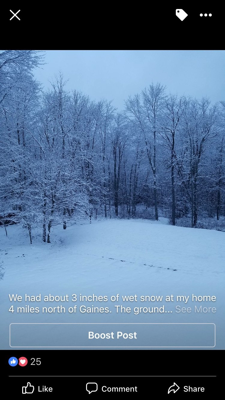
BTW 3" up at cabin last night. Friend lives 1 mile from my place.
-
Unfortunately that is a wise choice. HP in NE would help CCB into eastern locals early in the game, but verbatim the evolution is wonky, and we lose the critical levels until the UUL pops and wind/levels again become more favorable. I'd pay with all of the moolah in Sauss's wallet for this to happen in a few weeks from now when December is rockin, cause this would likely lay down the goods.
-
amen to that.
-
I'd just say proceed w/ caution. its still climatologically "early" for some of us, and the maps are really perty and wanna suck me in like a hoover....but its a marginal airmass and somewhat antecedent cold in its presentation, and barely cold enough at best. Razors edge for SE. Like Blizz suggested, cut totals WAY back for fringe areas. Major taint and if you look at the 6z GFS, it suggests alot of mixing issues. Still time and sure is exciting nontheless. Very happy to be where we are regardless the outcome. Nut
-
I really should get back on WXbell...miss them maps
-
i want PINK!!!
-
Still early for us down here. Although you can be snow starved, its still climatalogically easier to snow in your local. Geographically is where you struggle. I'll make a deal w/ ya...you give us some cold and we'll give you some precip (although you look just fine for this one)?
-
easy to see why. From free panels it looks marginally cold enough for that area. Closed off at 500 and 850's support western 2/3's and northern pa cold enough for white gold.
-
But you still get all hush hush when secretly tryin to hog all of our snow.....
-
Minor ice down here at best. I think we are out largely on this one. Points further north/west have some stale cold air that is deep enough to cause them some trouble LP position is just perfect. NAM extrapolated looks wetter than whiter. CMC says game on (as per GFS) and if you want snow in Downhereville go look at the evlolution of the 12z ICON. Crazy evolution for sure. Has SE pa snowbomb with rain further NW (likely dynamically driven event if it were to pan out as depicted). No way ICON can be right....but it would be cool to see no doubt. Were trackin...its mid november. All good (bonus) to me.
-
lol...you noticed that too huh....
-
#snowtv Normal disclaimer applies.....but i can see better potential for Thursday as the lower levels look better for true central pa (although taint likely for a period with normal caveats by geographic locations). North Central is big winner verbatim
-
IF it were another month later and we had the maps for this week showing up, we'd be giddy w/ excitement. Back to back and oh so close....
-
oh and............ Drops the shovel................