wxeyeNH
-
Posts
9,813 -
Joined
-
Last visited
Content Type
Profiles
Blogs
Forums
American Weather
Media Demo
Store
Gallery
Everything posted by wxeyeNH
-
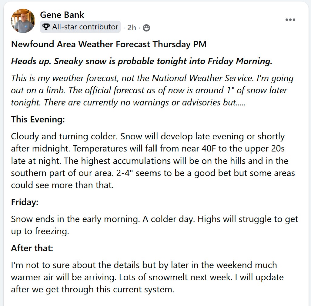
I put out a forecast for our 13K Newfound Lake facebook group. Since our weather is so different than Manchester, NH only TV station and because GYX is so far east I usually do pretty good. I totally disagreed with GYX when I posted this around 4pm. Let's see how bad I bust...
-
39.7/27.7F We were far enough north that we had some bright sun this morning into mid day. The temperature maxed out at 49F. Over the past couple of hours the temperature has been falling as well as the dew's. Especially the past hour. The point and click in our area is around 1" of snow. No advisories are up. The trend is your friend and I could see my area of the Lakes Region getting 2-4", maybe up to 5 or 6" if we can get the precip up here. It will be interesting to watch.
-
26.9F SN+ Vis 1/4"
-
39.7F first batch of showers were elevated here. Brightening to the west now.
-

"Don’t do it" 2026 Blizzard obs, updates and pictures.
wxeyeNH replied to Ginx snewx's topic in New England
I'm happy with my 1/4" of snow and more happy for the people who got 35 to 40". I see lots of pictures of people posting snowbanks and drifts. I'm looking for a video clip of someone who is able to drive and just video a neighborhood that got that much. Cars and areas not plowed should be pretty much buried. It is a good way to really judge. Most social media posts want to show the highest snowbank or drifted area. I just one to see a longer, honest video in the ground zero area. If anyone has a link I would love to see it! -
"Don’t do it" 2026 Blizzard obs, updates and pictures.
wxeyeNH replied to Ginx snewx's topic in New England
24.5F -SN Vis 3 miles. I am happy that we got .25". For fun over the last few years I have forecasted for our 13K Newfound Lake facebook group. I had predicted 2-4" but thought with White Mountain downsloping it might not be even that. All morning not a flake but we did get into some light snow so everything is dusted with new stuff. I am amazed that there has been almost no wind. Not even a breezy day. I don't understand why? -
"Don’t do it" 2026 Blizzard obs, updates and pictures.
wxeyeNH replied to Ginx snewx's topic in New England
We did it! 25.4F Visibility 6 miles. -SN Regarding the snowfall amounts. I think they are going to be all over the place with the amount of wind. -
"Don’t do it" 2026 Blizzard obs, updates and pictures.
wxeyeNH replied to Ginx snewx's topic in New England
We just had a flake too! 1150am! -
"Don’t do it" 2026 Blizzard obs, updates and pictures.
wxeyeNH replied to Ginx snewx's topic in New England
Kearsarge to my south is now hidden from view. I can still see Ragged clearly. -
"Don’t do it" 2026 Blizzard obs, updates and pictures.
wxeyeNH replied to Ginx snewx's topic in New England
Brian, not a flake here. I can see all the way south to Kearsarge and it has been in and out of the snow. No wind either. HRRR says NADA for me. Globals still say some. When would you say the furthest NW the sheild will get in our area? -
"Don’t do it" 2026 Blizzard obs, updates and pictures.
wxeyeNH replied to Ginx snewx's topic in New England
23.7F Cloudy. Vis 30 miles. Barely a breeze. HRRR says we may get by without a flake. -
It's the NAM. The 12Z gives me 0.00"
-
Yawn for me. Perhaps 2-4" with strong downsloping off the Whites. A day with light snow and windy conditions. Enjoy down there!!
-
Hey guys. So these are the days that we wait for, sometimes for years. Good luck down there. I really have not been paying to much attention as it has comfortably looked like a miss or scrape up here. Now I'm taking more interest. I guess my question would be, looking at the current runs would the defomation band get far enough NW to get me and Brian into the action? Usually in deep low's the White Mountains to my northeast shadow me. I'll be lurking and watching. Oh, 7" powder last night 24F light snow now
-
SN 28.1F About 5"
-
Friday February 6 FROPA / WINDEX small event
wxeyeNH replied to HoarfrostHubb's topic in New England
About 2.5" here. Winds are very light at the moment. Almost calm. We have had very little wind with this system. Boy, some impressive wind and cold to our southwest. -
Yeah Brian. Just hit 25F. With no wind and the higher sun angle it feels so comfortable outside. Light jacket seems fine!
-
17F Heavy snow. We missed out on the heavy action yesterday and last night but are making up for it this afternoon. Excellent snow growth. Visibility is still more than 1/4 mile but the large dendrites are accumulating very fast.
-
Approaching 8". Light snow has begun again.
-
Just light snow here in my area of Plymouth NH. 4" or so since 11am. No wind, no big deal for sure.
-
3F Light snow. It has been snowing lightly all day. 2" since 11am. Perhaps we had 15 minutes of moderate. So far way underperformer.
-
2F light snow. Pretty poor snow growth. Perhaps 1.25". Looks like the first band is about to hit us from the south.
-
2F Light snow. We really have only had light snow for the past 4 hours. 1 mile visibility stuff. Not great snow growth yet
-
Scott, maybe but I watched ABC evening news. This is going to be a catastrophic storm. No one has ever seen anything like this!
-
January 2026 regional war/obs/disco thread
wxeyeNH replied to Baroclinic Zone's topic in New England
I think since living up here I have only had a couple of days where I stayed below 0F all day. Just below, nothing like 1933. My record low is -19.5F with that brief brutal arctic blast a few years ago.