Freezing Drizzle
-
Posts
227 -
Joined
-
Last visited
Content Type
Profiles
Blogs
Forums
American Weather
Media Demo
Store
Gallery
Everything posted by Freezing Drizzle
-
Presidents' day Snow potential
Freezing Drizzle replied to WeatherGeek2025's topic in New York City Metro
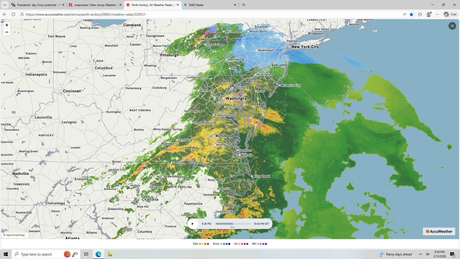
Those strong echoes in far south Jersey look like they've hit a wall. Not budging northward. -
Presidents' day Snow potential
Freezing Drizzle replied to WeatherGeek2025's topic in New York City Metro
Snowfall intensity has picked up nicely to a moderate rate, even though the heaviest echoes have passed. Reaching saturation? Down to 34 F. -
Presidents' day Snow potential
Freezing Drizzle replied to WeatherGeek2025's topic in New York City Metro
You are not alone. lol Over the years, I've noticed many quirky sticking patterns too. One is sticking in the expansion joints of sidewalks, but not on the sidewalk surface itself. Freezing rain glazes over cars more than on wood surfaces. Of course, sticking on grass before anything else. Sticking on rough pavement surfaces before smooth pavement. -
Presidents' day Snow potential
Freezing Drizzle replied to WeatherGeek2025's topic in New York City Metro
Don't get too excited, I'm under it and it's very light...at least for now. -
Presidents' day Snow potential
Freezing Drizzle replied to WeatherGeek2025's topic in New York City Metro
In this huge system, look where it's snowing. Lucky us. lol Raining out in Williamsport and State College, PA.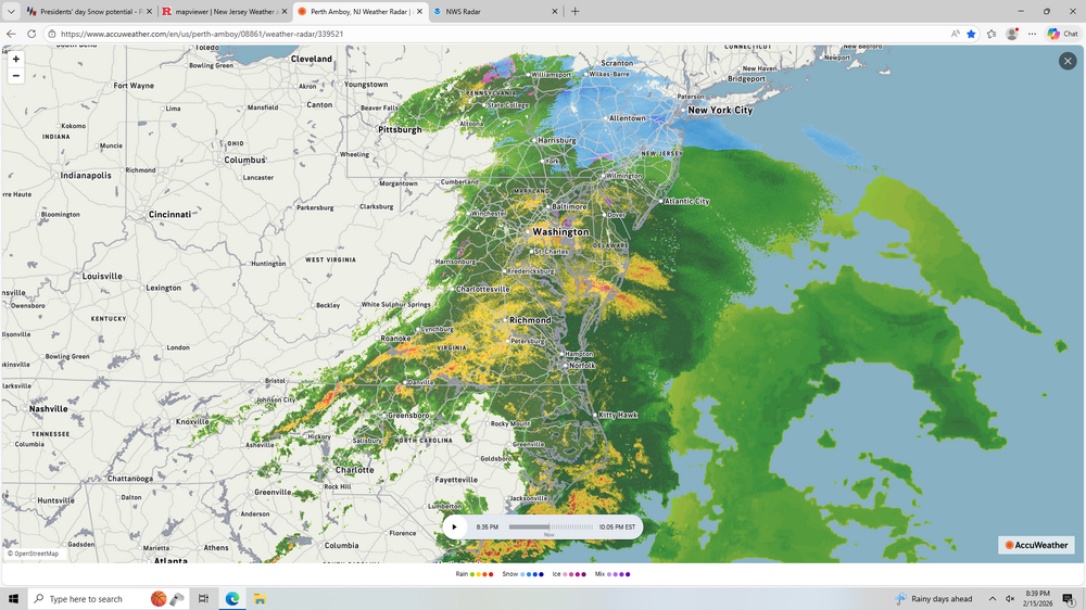
-
Presidents' day Snow potential
Freezing Drizzle replied to WeatherGeek2025's topic in New York City Metro
Light snowfall here too. 36 F. Very still. -
February 2026 OBS & Discussion
Freezing Drizzle replied to Stormlover74's topic in New York City Metro
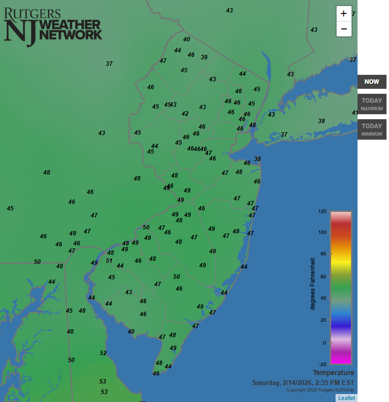
Temperatures are within a remarkably narrow range in this forum's area, 35 to 40F.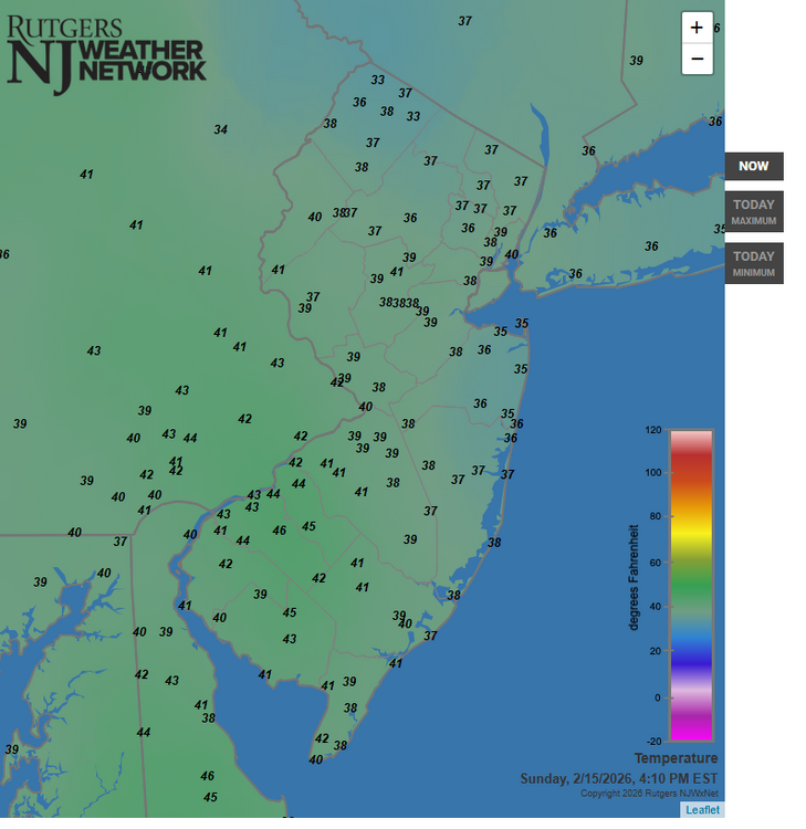
-
Nice story. @coastalplainsnowman I was at work near the Metropark Station in Iselin of Woodbridge Township, NJ. Hit like a wall. Was not forecasted well. My company waited a bit too long to dismiss us. Roads were near gridlocked at Metropark. Took backroad routes to get home rather than get on the GSP, which was crawling, at best. Occurred during that big-snowstorm "drought" from PD I in February of 1979 to the 1990s. I have notes on it somewhere. I think I got in the low 20s inches.
-
Presidents' day Snow potential
Freezing Drizzle replied to WeatherGeek2025's topic in New York City Metro
Mt. Holly also predicts "freezing fog" tonight at least for northern Middlesex County, NJ, with a low of 23 F. I haven't seen that term in a NWS forecast in a while for this area. -
Presidents' day Snow potential
Freezing Drizzle replied to WeatherGeek2025's topic in New York City Metro
Upton for Staten Island and Mt. Holly for locations in Middlesex County, NJ are both going with 1-2 inches tomorrow night now. -
February 2026 OBS & Discussion
Freezing Drizzle replied to Stormlover74's topic in New York City Metro
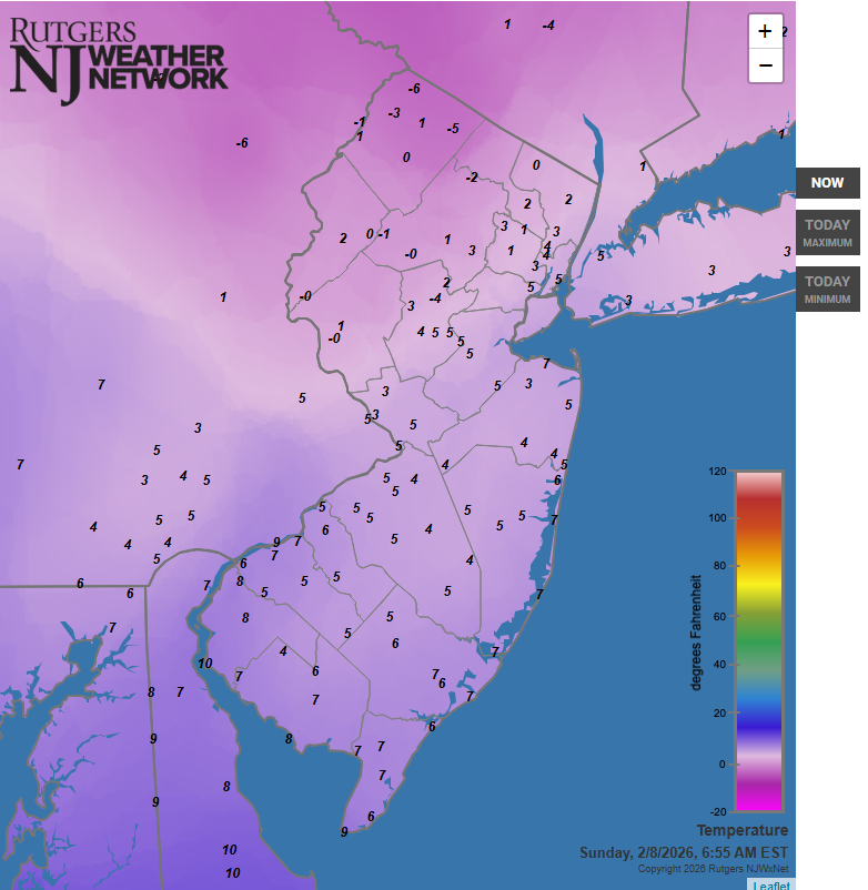
Mount Pocono, Vernon, and some points on Long Island are the only locations shown that are currently in the 30s F.
-
February 2026 OBS & Discussion
Freezing Drizzle replied to Stormlover74's topic in New York City Metro
This data will keep me busy for a while. lol I am much obliged. @donsutherland1 -
February 2026 OBS & Discussion
Freezing Drizzle replied to Stormlover74's topic in New York City Metro
Don, does historical snowfall data exist for any points like State College or Williamsport? When I was young, it seems that we had tracks that hugged the coast or ran up the spine of the Appalachians. Those tracks would hit central PA hard. FD ps Love your posts, here. -
February 2026 OBS & Discussion
Freezing Drizzle replied to Stormlover74's topic in New York City Metro
A dusting possible from a weak shortwave passing through overnight 3 to 5 am. Carry on. -
February 2026 OBS & Discussion
Freezing Drizzle replied to Stormlover74's topic in New York City Metro
Yeah, I'm near the boat basin. I think it was April, 2000, woke up to a winter wonderland on a Sunday morning. About three inches, stuck everywhere. The sun came out and by noon it was like it never happened. -
February 2026 OBS & Discussion
Freezing Drizzle replied to Stormlover74's topic in New York City Metro
Desperate, deer will nibble on just about any foliage, including tender tips of branches. The weaker deer die off. When I was a kid, while driving to Pennsylvania to visit relatives, we'd say, "Ooh, look, deer!" We don't say that anymore. They live in the marshes and woods in parts of Woodbridge, Edison, and Sayreville Townships. Some wander into the outskirts of Perth Amboy. My cousin near Lebanon, NJ has so much deer scat on his back lawn that it's almost unusable for activities. -
@The 4 Seasons Great archives page! Saved as a favorite.
-
February 11-12, 2006. My notes: 11th - Snowfall started 3 pm. Two inches by midnight. 12th - Thunder snow 7:15 am. Heavy rates 7 to 10 am. 17.5 inches total. @PhiEaglesfan712
-
February 2026 OBS & Discussion
Freezing Drizzle replied to Stormlover74's topic in New York City Metro
Yeah, my notes read: "Rain, to sleet, to snow. 5.9" in am." @weatherpruf Your area is usually a bit colder than here (except for BDCFs lol); unless I was in a local band. -
February 2026 OBS & Discussion
Freezing Drizzle replied to Stormlover74's topic in New York City Metro
Light to moderate, cold rains can build a snowpack, rainfall wicks in and re-freezes. A great example of that was 2000-2021. -
February 2026 OBS & Discussion
Freezing Drizzle replied to Stormlover74's topic in New York City Metro
Like a football score lol -
February 2026 OBS & Discussion
Freezing Drizzle replied to Stormlover74's topic in New York City Metro
Good morning. 6:55 am.
-
February 2026 OBS & Discussion
Freezing Drizzle replied to Stormlover74's topic in New York City Metro
Current temperatures.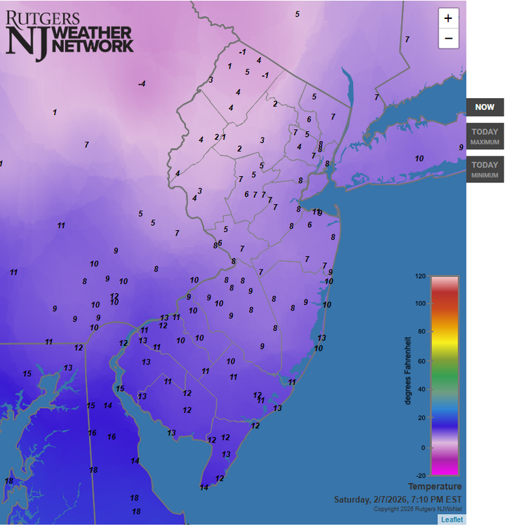
-
February 2026 OBS & Discussion
Freezing Drizzle replied to Stormlover74's topic in New York City Metro
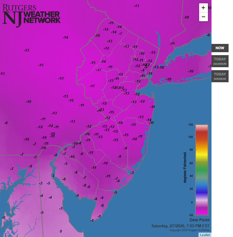
Dewpoints, wow.
-
February 2026 OBS & Discussion
Freezing Drizzle replied to Stormlover74's topic in New York City Metro
Gap in my education...so PD I was the snowstorm of February 1979? That one is kind-of a forgotten storm, I recall a foot or so. Would you happen to have a snowfall map? @Tatamy