Freezing Drizzle
-
Posts
227 -
Joined
-
Last visited
Content Type
Profiles
Blogs
Forums
American Weather
Media Demo
Store
Gallery
Everything posted by Freezing Drizzle
-
Still measured/conservative amounts. I don't blame them, really. They are broadcasting to a huge public audience, not to a forum. They almost always leave room to increase amounts as they look more certain.
-
My original point got a bit lost. I was only showing what AW and the NWS were telling the public in their (measured/conservative) weather discussions in text/writing. The public does not know what we do about maps, etc. You are right though; they seem to have a standard time forward where they will show inches in writing. Looks like about 60 hours. For example, still no inches shown in writing for Sunday night for my area. Ok we're good.
-
For the record, January 7-8, 1996 started late on Sunday morning.Carry on.ps - If the GFS verifies, I would love a post-mortem read from you guys on what the GFS detected, that the others missed.
-
I believe you are technically correct. After a fluffy snow, if sustained winds occur at blizzard level, but the sun comes out, it's likely still a blizzard, by definition. In a recent discussion we discussed the "one inch blizzard," don't recall fully, but the sun may have indeed come out after that snowfall ended.
-
Hi RU, I like your posts, and the fact that you are just to my NW. The forecasts in text this morning for the two areas were exactly as I wrote. Since then, Mt. Holly downgraded it to this for Perth Amboy: Sunday Snow likely, possibly mixed with rain before 7am, then snow. High near 38. East wind 5 to 15 mph. Chance of precipitation is 80%. New snow accumulation of around an inch possible. Sunday Night Snow likely. Cloudy, with a low around 30. Chance of precipitation is 70%. However, Upton, for Staten Island, has increased the inches in their text forecast: Sunday Snow likely, possibly mixed with rain before 7am, then snow. High near 37. East wind 10 to 15 mph. Chance of precipitation is 80%. New snow accumulation of 1 to 2 inches possible. Sunday Night Snow likely. Cloudy, with a low around 30. Chance of precipitation is 70%. New snow accumulation of 2 to 4 inches possible.
-
AW is also going with a broad 1-3 inches away from the immediate NJ coast. Their write up has plenty of (reasonable) caveats for an upside, however.
-
February 2026 OBS & Discussion
Freezing Drizzle replied to Stormlover74's topic in New York City Metro
-
February 2026 OBS & Discussion
Freezing Drizzle replied to Stormlover74's topic in New York City Metro
Drought map -- CA, no drought in the state I thought northern FL got a soaking rain this week from that southern storm. Part of north Jersey? You guys up there seeing this? Part of Northern Arkansas, wow. -
NWS for central NJ (Mt. Holly) through the Five Boroughs (Upton) is going with a middle ground, 1-2 or 1-3 inches, forecast.
-
How about deleting them to avoid confusion?
-
February 2026 OBS & Discussion
Freezing Drizzle replied to Stormlover74's topic in New York City Metro
"1993: Intense snows caused by a "norlun" instability trough hit parts of Massachusetts. Chatham, MA picked up 20 inches of snow. For 3 hours, the snow fell at a rate of 4 inches per hour. (Ref. Wilson Wx. History)" Now, THIS was some norlun. -
Related to what's called geophagia, the eating of earth, usually clays. Some think that this phenomenon is due to a deep instinct to consume minerals and to adsorb toxins in the gut. I recall that it's most common with women.
-
Yeah, @weatherpruf has a point about this period of winter.
-
www.weather.gov/media/okx/Climate/CentralPark/BiggestSnowstorms.pdf In the period of late February.
-
Hmmm. Fwiw, on the 12"+ snowstorm list for CPK (28 total), only one is in late February, February 25-26, 2010.
-
February 2026 OBS & Discussion
Freezing Drizzle replied to Stormlover74's topic in New York City Metro
Thanks Don. Sorry, I didn't catch that point. I recall very cold, light, fluffy snowfalls that season; they did last, though. -
February 2026 OBS & Discussion
Freezing Drizzle replied to Stormlover74's topic in New York City Metro
Good summary of that period. February 1995 did have that one-footer for most of our region; I guess you alluded to that one. -
February 2026 OBS & Discussion
Freezing Drizzle replied to Stormlover74's topic in New York City Metro
Hi Don, I'm surprised to see that 1976-1977 winter is not on this list. Perhaps there was a warm spell(s) that increased the mean average for the period? FD -
One purpose of this thread is to de-clutter the general February thread.
-
February 2026 OBS & Discussion
Freezing Drizzle replied to Stormlover74's topic in New York City Metro
Thanks for posting the snow map for PD I, February of 1979. A bit of a "forgotten" storm from that era of scarce, big storms. -
Presidents' day Snow potential
Freezing Drizzle replied to WeatherGeek2025's topic in New York City Metro
No, Don. -
Presidents' day Snow potential
Freezing Drizzle replied to WeatherGeek2025's topic in New York City Metro
Average of five snowboards - 1.1". Low of 32 F. Pavement accumulations were 3/4 inch on the north side of my house (sun does not shine on the pavement there in the winter), to Trace/Bare on the south side. I'm almost always warmer than Metuchen. I'm in a micro-climate near the Raritan Bay. Colder here during spring BDCFs, though. lol ps - The pond on the south end of town? If so, we almost bought a house near this pond 25 years ago, but the asking price was too high. -
Presidents' day Snow potential
Freezing Drizzle replied to WeatherGeek2025's topic in New York City Metro
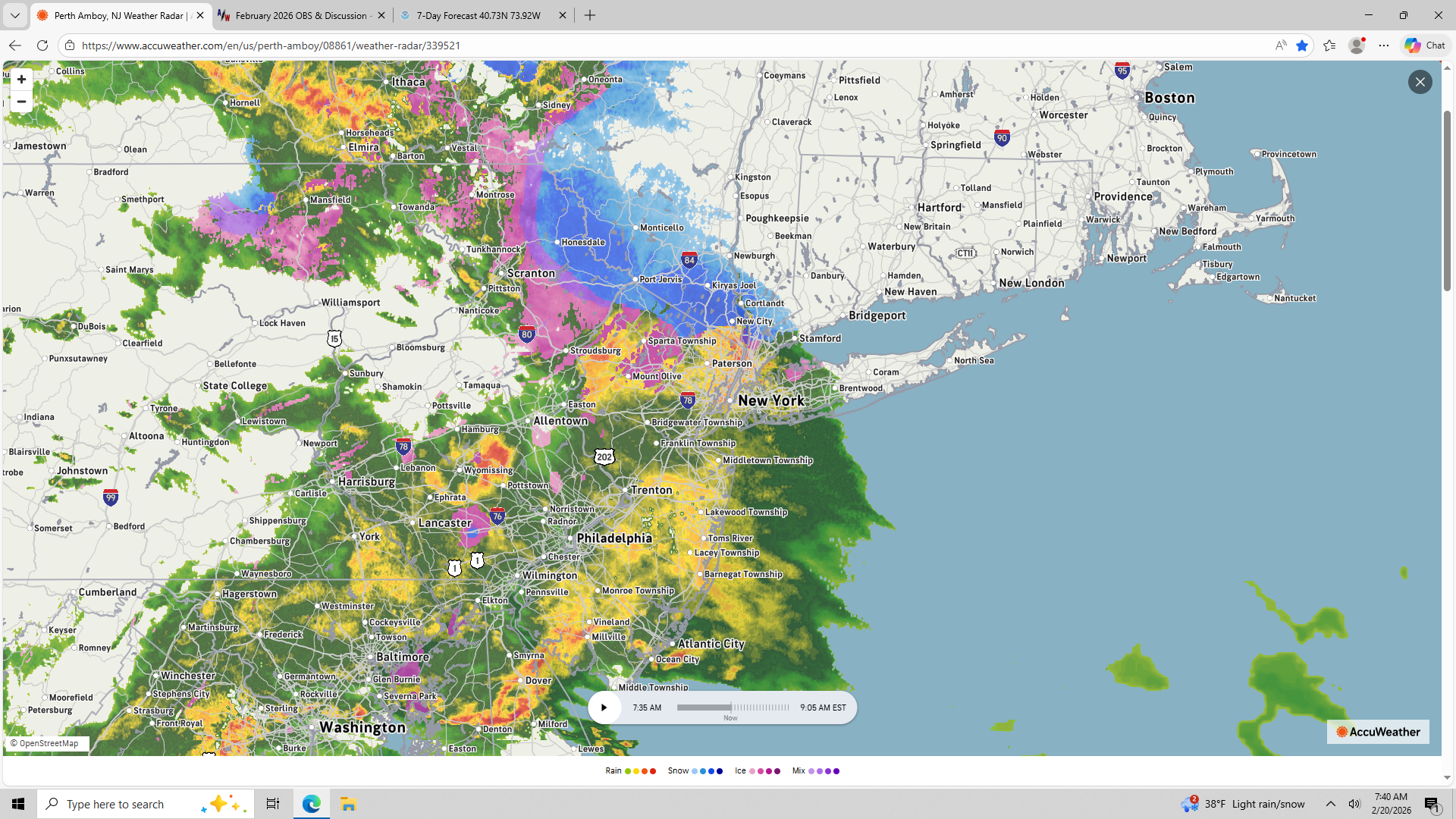
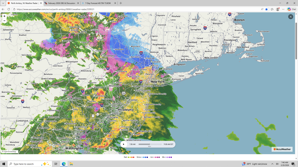
Something odd with the NWS radar. Snowing very hard now, under 10 dBZ echoes? -
Presidents' day Snow potential
Freezing Drizzle replied to WeatherGeek2025's topic in New York City Metro
Enjoy, Metsy. -
Presidents' day Snow potential
Freezing Drizzle replied to WeatherGeek2025's topic in New York City Metro
Now we're cooking with gas. Coming down at 1/2 inch per hour+ rate. Starting to stick on typical favored surfaces.