

Freezing Drizzle
-
Posts
227 -
Joined
-
Last visited
Content Type
Profiles
Blogs
Forums
American Weather
Media Demo
Store
Gallery
Everything posted by Freezing Drizzle
-
2/12/2006, on your list. @Amped 8 am that Sunday morning. Showing 35 to 40 dBZ echoes over my local area. The greatest snowfall rate during a major storm that I can recall.
-
So, I live just south of the "6-8"" under Newark. Boy did it come down that hour!
-
@Amped Here is one for you. March 7, 2018 My notes: Schools closed. Heaviest snowfall rate ever witnessed, from noon to 1 pm. 5.5" total. [The schools in Perth Amboy were closed based on the forecast. It had looked like a bust, with only light snowfall in the morning. Then, came down at a rate of around 4 inches per hour for about an hour.)
-
Good list. The two of the heaviest snowfall rates that I've seen were not in big snowstorms. I'll look up the dates. Curious if others witnessed them.
-
February 2026 OBS & Discussion
Freezing Drizzle replied to Stormlover74's topic in New York City Metro
Great data list, @SACRUS Were the measurements done somewhere in Newark-proper before the airport was established? Does the airport location goes back to 1931? -
You know the forecast is uninteresting when the Banter thread has the most recent post.
-
Yeah, a steady, moderate snowfall started for my location around 1:30 pm yesterday, too.
-
That is one persistent band over the Five Boroughs! A heavy part of that band is hammering the area around Neptune, NJ now; near the border of Monmouth and Ocean Counties. Still in moderate snowfall, here.
-
Please remind us what year EWR records began.
-
I mentioned RU in the list, in Metuchen. You do give conditions though. I'll send you a yardstick if you want one. lol
-
Could be, some hotspots under these bands.
-
Love the fact that we have guys like RU..., weatherpruf, blizzardo also in the area. Fun to check totals against others. In marginal temperature situations, places like Metuchen and Colonia almost always get more than me down by the Raritan Bay.
-
Don, same here. Look to add a few more inches with this arc-shaped band.
-
Wow, you did great way up north. Good for you!
-
Rjay, that Rutgers conditions map set, that I post sometimes, used to give you the PAST 12 hours of radar. One could wake up and look back at what happened overnight. It was great, but hasn't worked in a couple years.
-
I have this too, first time I can recall this happening to this extent. Most of my windows are so plastered that you can't see out.
-
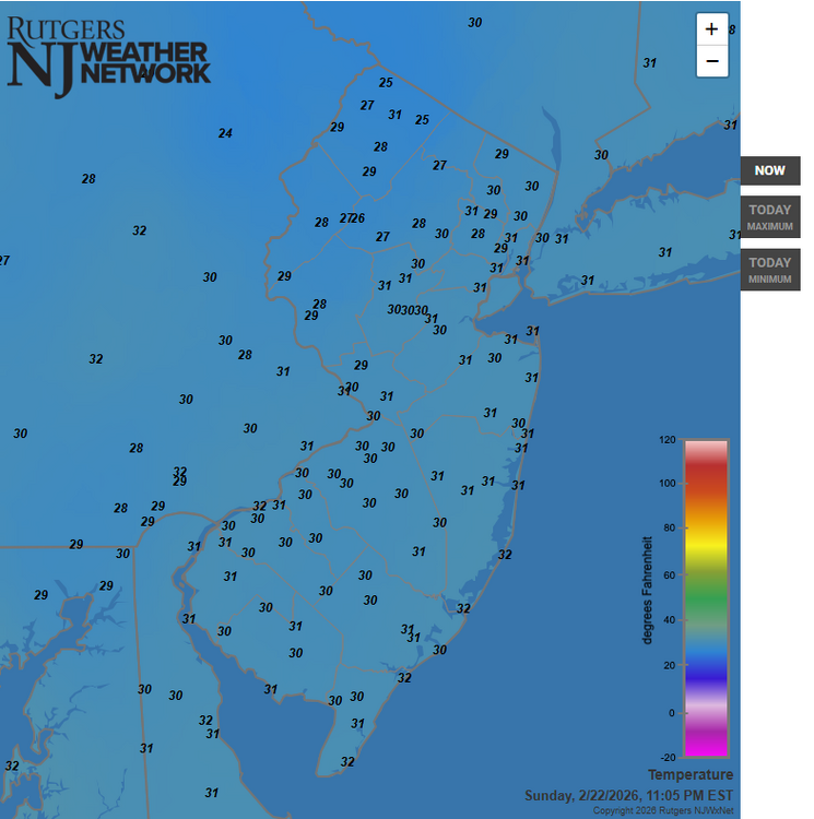
Remarkable uniformity in temperatures in NJ. Only seven degrees from current high to low.
-
Haven't heard of any.
-
An hour ago.
-
Yardstick here says 8 1/2". In a marginal temperature event, Metuchen will get more than me down here by the bay; I've seen it 100 times. In cases, like this system, about the same.
-
Guys, just measured 5 1/2 inches. Getting it good under these 25-30 dBZ echoes. 31 F
-
4 1/2 inches, here to your southeast. Got into those 25 to 30 dBZ echoes a while ago. 31 F
-
Ant, are these storm totals, or additional from now?
-
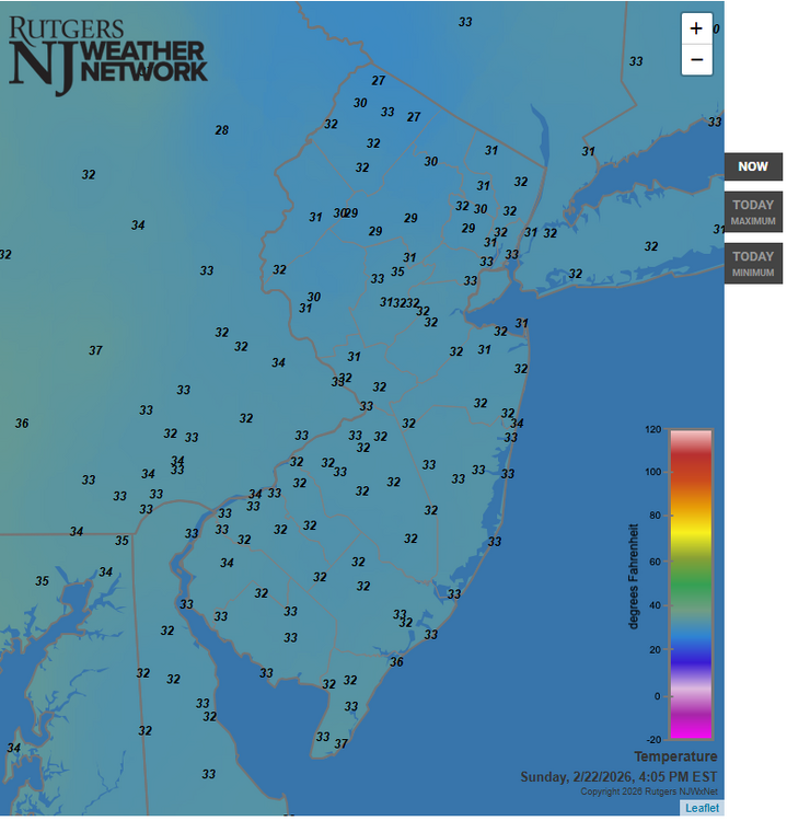
The 32 F isotherm line has rapidly plunged well south into southern New Jersey.
-
lol "Death band" forming just north of Atlantic City?


