Freezing Drizzle
-
Posts
227 -
Joined
-
Last visited
Content Type
Profiles
Blogs
Forums
American Weather
Media Demo
Store
Gallery
Everything posted by Freezing Drizzle
-
Me too. Staten Island forecasts verify more often, over the years, versus Mt. Holly, which seems to lump me in with the area south of me. I'm actually a few hundred yards from the boundary of the two offices.
-
Those 25 to 30 dBZ echoes are nearing the Raritan River. ps what is your location when you post your conditions? @SACRUS
-
Just started snowing hard here, as shown graphically in the radar. (After two hours of "wet" snow flurries and snow showers.) FD Favored surfaces are whitening over now.
-
DS, 96 did start right around the same time, but was MUCH colder, in the 20s F as the first flakes fell. A classic rain-to-snow for my area was Christmas Day 2002.
-
Current - the 32 F isotherm line roughly runs from western Passaic County westward to the Poconos.

-
@SACRUS was Jan 26–27, 2011 (– 19.0") the storm that shut down parts of Monmouth/Ocean County with totals around 30 inches? [My notes show 17.75 inches, here in Perth Amboy.] @weatherpruf @RU848789 Do you guys remember it? My sister lived in Bradley Beach and could not get out of her property for days.
-
Light sprinkles of rain at 37 F here.
-
Does anyone remember Tex Antoine from ABC? One of the first weather guys to explain some meteorology, with a little personality. At the time, most weather was simply presented as a forecast. He was drunk on air one evening, said something distasteful, and was summarily fired.
-
and 1979, PDI; 78 January too.
-
February 2026 OBS & Discussion
Freezing Drizzle replied to Stormlover74's topic in New York City Metro
Great article! Love the historical research, as always. Now I can amaze family and friends. -
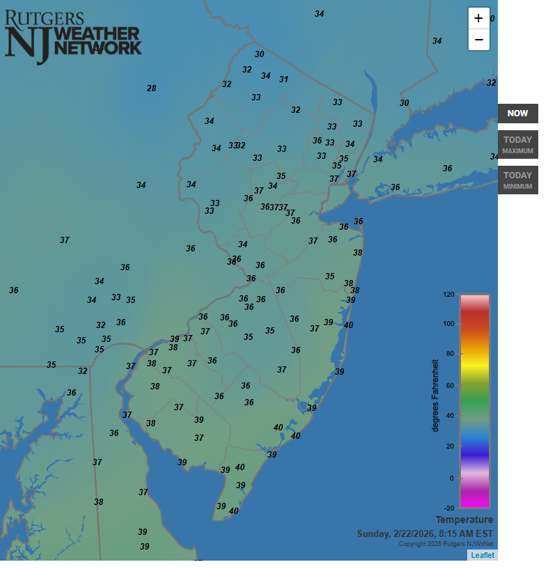
Now, that's NJ....
-
16 to 28 inches, in Sayreville....crikey.
-
NWS shows 2-4 inches, for now.
-
You gotta' read all of the 20 pages just like others do.
-
Thanks for looking further Don, the late-"Icehater" had an amazing memory of details for weather events.
-
In the blink of an eye you'll be attending his high school graduation. Trust me, it's that "quick."
-
Much obliged. Perhaps he meant that it was above freezing for an extended period during the snowfall before the lows for the day were reached.
-
@donsutherland1 Good morning, the late-"Icehater," a great poster on the old NYC Metro forum wrote that the temperature during the "Lindsey Storm" of February, 1969 hovered around 34 F and never went below freezing. Would you have temperature data for that storm for CPK or other points? FD
-
I think our wives are twin sisters separated at birth.
-
Yeah, it happens that I live several hundred yards from the dividing line of Upton for Staten Island and Mt. Holly for northern Middlesex County. Over a few decades, Upton, for Staten Island, has been most accurate for me. Mt. Holly seems to include my town with the area just to my south in northern Monmouth County. Thus, Mt. Holly forecasts for me tend to be a bit warm.
-
He's good. I remember him, still a student, on the old Evans AW page. Glad he's successful.
-
Maybe Steve tried playing the anti-weenie and got burnt? It happens.
-
Dave Curran? He's been a sole "keeper" with them. Others from years ago, including Jim Gregorio and Michelle Powers are long gone. An annoying thing about News 12 weather -- they broadcast old weather spots without indicating so, for years now. It's really irresponsible. You'll see what you think is current radar, for example, and realize, "that's from hours ago."
-
I know; I live with one. lol Seriously though, my town's streets have not recovered from the solid embankments of snow, which encroach into the roadway and are very difficult to remove. More snow is going to be a problem.
-
Dollars to doughnuts he's waiting for more consensus, based on the next Euro run(s).