Freezing Drizzle
-
Posts
227 -
Joined
-
Last visited
Content Type
Profiles
Blogs
Forums
American Weather
Media Demo
Store
Gallery
Everything posted by Freezing Drizzle
-
31 F even here. Open water outside were all frozen.
-
NWS for Pittsburgh -- Tonight: Snow likely, mainly before 9pm. The snow could be heavy at times. Cloudy, then gradually becoming partly cloudy, with a low around 23. West wind 15 to 17 mph, with gusts as high as 33 mph. Chance of precipitation is 70%. Total nighttime snow accumulation of 2 to 4 inches possible.
-
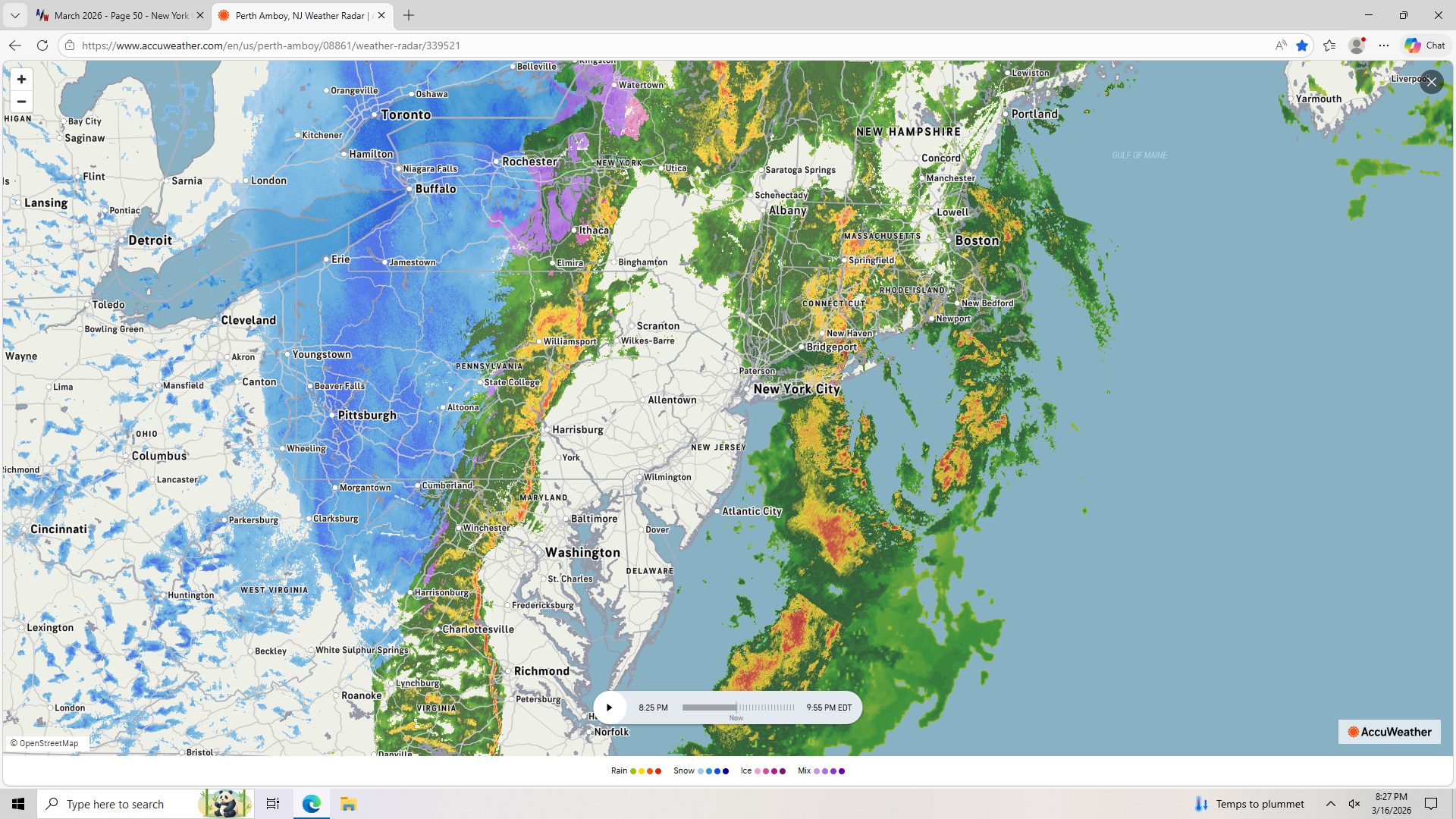
Huge dry slot. The line approaching runs from NY State down to VA. Has reached Williamsport.

-
Dense fog still holding on here. 61 F, DP 60 F.
-
Some nice places for you to re-locate, Metsy!
-
Rain/Thunder and Anafrontal Snow
Freezing Drizzle replied to WeatherGeek2025's topic in New York City Metro
Like most here, had varying snow showers, from 3:20 pm to 6 pm, no accumulation. Lowest temperature was 36 F. Did have a neat graupel shower at 9 pm. I never knew that the METAR code for graupel is GS. -
Rain/Thunder and Anafrontal Snow
Freezing Drizzle replied to WeatherGeek2025's topic in New York City Metro
Went over to snow at 3:20 pm, with no transition, moderate rate. -
Rain/Thunder and Anafrontal Snow
Freezing Drizzle replied to WeatherGeek2025's topic in New York City Metro
Sleet mixing in here too. 41 F, DP 29 F -
I think soon too. You're the NW spotter today.
-
Rain/Thunder and Anafrontal Snow
Freezing Drizzle replied to WeatherGeek2025's topic in New York City Metro
I see snow echoes on a line from Hazleton to Harrisburg, but not sure what's falling there. I've seen snow under rain echoes, and rain under snow echoes. Usually, the snow detection is rather good though. -
Hi, I hear you. They were great winters. Definitely among the best in your teen-adult years. Gonna' give the "+" to 95-96 still. Just one fact, 40 to 50% more snow at CPK versus 13-14 and 14-15. btw my son lives in Philadelphia now, so I this Giants/Mets fan can't dislike the Eagles and Phillies as much. lol
-
Rain/Thunder and Anafrontal Snow
Freezing Drizzle replied to WeatherGeek2025's topic in New York City Metro
Anafronts A rainy cold front is usually an anafront. Anafronts are the kind of cold front associated with moisture and clouds. Ana means to ascend. What’s ascending in the case of an anafront? The warm and moist air — it actually rises over the lower leading edge of the cold front and can create clouds and rain behind the actual cold front itself. -
Isn't it cool by you today?
-
Dividing line roughly along the GSP.

-
East wind off the water, 59 F here. Enjoy it, inland guys.
-
There it is, the 138th anniversary of The Blizzard of 1888. Family history has it that my great-grandfather, an immigrant grocer in Bridgeport, CT, had the 6th sense to stock up on provisions as the storm was brewing. Thus, he was able to help out his local community through the aftermath of the storm.
-
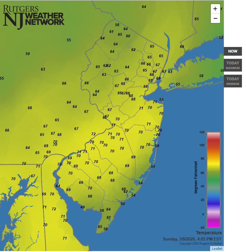
At the battle line of cool maritime air and inland warmth, 71 F after reaching 75 F.
-
"1884: John Park Finley issued the first experimental tornado prediction. Finley studied the atmospheric parameters that were present during previous tornadoes. Many of these same criteria are still used by operational forecasters today. But the use of tornado forecasts would be banned just a few years later and remain forbidden until 1952." Why were forecasts banned? Do you know? Found this. http://site.extension.uga.edu/climate/2025/03/tornado-forecasting-was-banned-in-the-u-s-for-60-years-why/
-
Track the Mets season. Let's go Mets! Let's go Mets! We'll miss the Polar Bear though....
-
Have to save A+ for 1995-1996. This season will get an A. It occurred to me that for one to have experienced 1995-1996 with some degree of understanding, you would have to be at least 40-45 years old now. For anyone younger, check out that season's frozen events on Ray's Winter Archive; November to April.
-
Hit 70 F from northern Monmouth southwest to Delaware.
-
Good find. My grandfather witnessed that 30-inch March as a seven-year-old.
-
My location got 5.5 inches in the first of the two, and inch of slush in the 2nd one. Surprised you didn't get as much. Up north, they got more in the 2nd.
-
March 2004, the season with two March storms, both in mid-March, after no snowstorms in February. Check the synoptics out.http://www.raymondcmartinjr.com/weather
-
Too small to read. http://www.jdjweatherconsulting.com/mar-4-5-2015 I got about 8 inches in that one.