

mississaugasnow
-
Posts
1,236 -
Joined
-
Last visited
Content Type
Profiles
Blogs
Forums
American Weather
Media Demo
Store
Gallery
Everything posted by mississaugasnow
-
Ya, I am not expecting a blockbuster by any means. Right now if Toronto can get 1.7 inches of snow or more from this system it would produce the snowiest Nov.12th on record. The 13th would be a bit tougher to break but the daily record is still only 3.5 inches. Right now the models are showing a widespread 2-4 inches in the GTA. Sorry for the in your backyard analysis.
-
Been following this possible event for the last few days. Would be one of the earliest widespread advisory to warning event I've seen so early in the season. Arguably winter weather advisories from Texas to Maine.
-
Upstate/Eastern New York
mississaugasnow replied to BuffaloWeather's topic in Upstate New York/Pennsylvania
Looks like the GTA would see around 1-3 inches of snow with that run with little mixing issues aside from immediate lakeshore. Sign me up for that run. -
Upstate/Eastern New York
mississaugasnow replied to BuffaloWeather's topic in Upstate New York/Pennsylvania
Definitely all gravy. This is my first winter away from the Lakes. I used to live right on the lakeshore just outside Toronto. Now I live up on the Niagara Escarpment about 220M or 720 feet higher. I've asked a few local meteorologists what to expect and they mentioned a lot more snow compared to those right along the lake (Hamilton DT, Grimsby, St.Catherines) Though not by much, i am also closer to you guys when tracking snowstorms. -
Upstate/Eastern New York
mississaugasnow replied to BuffaloWeather's topic in Upstate New York/Pennsylvania
I know heat is coming but today stayed in the middle to upper 40s in the GTA with a consistent mist. The colour change up this way is really taking off now, noticed it on my drive into work this morning. -
2018 Short to Medium Range Severe Thread
mississaugasnow replied to tornadohunter's topic in Lakes/Ohio Valley
Tornado warnings on the Canadian side of Lake st.Claire as well -
Upstate/Eastern New York
mississaugasnow replied to BuffaloWeather's topic in Upstate New York/Pennsylvania
any first guesses for first freeze and snow? Toronto: First freeze October 9th/ first snow October 15th Buffalo: First freeze October 9th/first snow October 10th Rochester: First Freeze October 9th/first snow October 21st as you can tell I think some of that arctic air building out west in the Canadian prairies finally pushes the bermuda high slightly east in mid october and has some staying power. Im thinking if it can make it this far east, we would be looking at highs in the 40s and lows in the upper 20s. Though were right on the boundary of the bremuda high and we could easily see ourselves staying in the 60s/70s while the western lakes turn cold. -
Upstate/Eastern New York
mississaugasnow replied to BuffaloWeather's topic in Upstate New York/Pennsylvania
I would rather have the colder pattern hang off for a couple more weeks. By mid october the lake effect snow machine can easily produce 6"+ snow events -
Spring/Summer 2018 Banter and Complaint Office
mississaugasnow replied to IWXwx's topic in Lakes/Ohio Valley
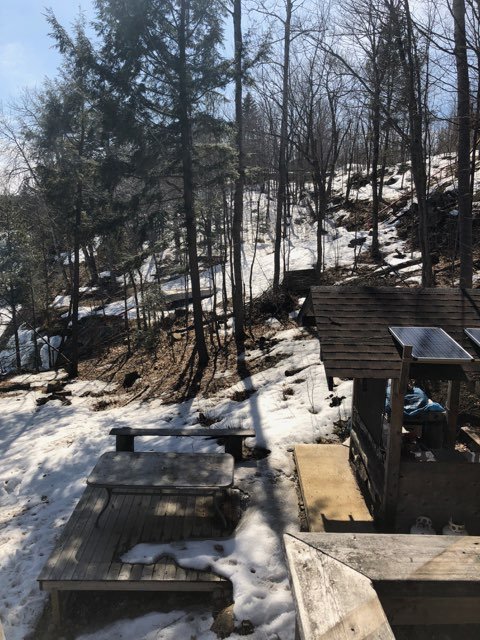
This was taken about 40 minutes NE of Parry Sound (3 hours north of Toronto) at the family cottage. Ice is still about 22 inches thick on the lake, but as you can see a lot of snow has melted. Great weather though for getting the cottage ready for summer, the people that winter up here said that winter has essentially been over for about a month as well. I wonder what an early snow melt and dry march will mean for the fire season. Not looking for a washout of a spring, but a couple good storms spaced out will do wonders to minimize the fire risk come May-September.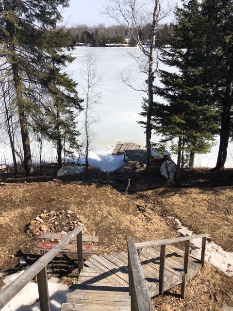
-
Thanks for the replies. Im driving down to the gulf coast soon and always look forward to the first significant signs of spring. Sounds like it will be noticeable by Tennessee. Still have some patchy snow cover and nights in the low 20s up here so it will be nice to see a different landscape. What you guys are describing is what I normally notice around mid April to early May
-
Nice photos. Hows the green up coming along down there? Noticed lots of 60s-70s over the 7-10 days, have the trees and vegetation started responding?
-
How quickly do you think you guys will green up in the next 10 days? Looks like solid upper 50s to low 70s and lows in the 40s and 50s region wide. Im driving down to New Orleans towards the end of the month and always enjoy that first stop where theres green grass and signs of spring.

