

mississaugasnow
-
Posts
1,237 -
Joined
-
Last visited
Content Type
Profiles
Blogs
Forums
American Weather
Media Demo
Store
Gallery
Posts posted by mississaugasnow
-
-
22 minutes ago, michsnowfreak said:
DTW reported 2.4" snowfall on 0.28" liquid today.
It's officially Detroit's wettest January on record at 5.25", breaking the previous 1932 record of 5.02".
Snowfall for the month, while not a record, was also above average. At 17.0" this ranks is the 27th snowiest January on record. The snowiest January was set 10 years ago (39.4") during the unforgettable 2013-14 winter. Season to date snowfall at DTW is 19.5".
I saw 1.8" today, bringing my monthly total to 16.0" and the season to 18.1".
wow, you guys have been cashing in down there. Toronto will finish with around 11" which is pretty much normal for January.
-
 1
1
-
-
11 minutes ago, Snowstorms said:
And the next 10 days look snowless too. Unless things turn around late Feb and March, were currently on track for a top 5 winter. Your call still going strong haha.
Below is the Toronto station (going back to 1840).
Ya, it will have to be a very snowy 4-6 week period. The biggest storm this year has only been 3" haha. To get anywhere near normal would mean multiple 4-8" storms.
Unless the season comes out in the second half of February like SF did last night this season is getting close to being a dud. As a Bills fan I feel for the Lions this morning but I couldn't resist putting that reference in.
-
53 minutes ago, Snowstorms said:
Yes I agree. Some weak or moderate El Nino's can be great for us too. Sorry it took me a while to get back to this, had to total up all the winters since 1840 in Toronto lol. Here's our top 20 least snowiest winters. Note I did not use YYZ for the top 20. I used our Toronto station, from 1840-1994 and then used our North York station from 1994-present.
The red highlighted are the more recent winters (i.e., since 2000). Our average snowfall every winter is around 50" (45" at YYZ).
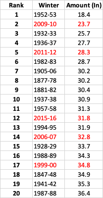
If I used YYZ then 2011-12, 2009-10, and 2006-07 would be in the top 5. But YYZ's measuring standards are questionable.
Found North York but incomplete data for January so far.
Assuming its a bit higher compared to YYZ, North York is probably around 18" whereas YYZ is 16"
Hamilton is at 10.2" on the year.
That one storm in mid January has created a big gap across the GTA
-
1 hour ago, beavis1729 said:
Disclaimer: Tenor of the post is as a fellow weenie, separate from you and your colleagues being valued NWS employees...
The issue, as always, is that our expectations are so low. When people resign themselves to the fact that 10 days of winter (regardless of ENSO state or various indices) is acceptable, where does that leave us? Even if the 10-day stretch is really good (in this case I'd give it a B or B+ since our friends in the city missed out and it had the potential to be even better), would we ever be ok with 10 days of summer? In summer, people don't care about the indices - it's just summer. Sure, some patterns can be 70s and humid and others can be 90s and dry, but it still feels like summer either way simply because of the calendar.
Can't chalk it all up to a strong El Nino. Last year didn't feature that, but the winter was still horrible. It's maddening to have to depend on the perfect alphabet soup of indices to get winter. Shouldn't the calendar be enough?
Our problem is temps, not precip/snow. A day with a high of 15F in January shouldn't be a big deal. Sure, it's a bit cold...but nothing crazy. The problem is that it needs to be offset by another day with a high of 45F, since our average high in Jan is 30F. The good patterns can be really good, but it's short-lived and everything else is bad. Would have been nice to follow up the 10-day good pattern with regular winter, like highs 25-30F and lows in the teens with a bit of snowfall. Nothing crazy, just some basic winter-type stuff. But it's always way up and way down. We never get "normal" winter weather here. It's either a good pattern which you hope produces in a short window...or nothing.
And it's even worse because all of those comments are referencing Jan, the core of winter. Dec/Feb are even worse, as average monthly highs are higher, around 35F.
The problem with low expectations is that it makes people think they should be ok with 10 days of winter, when DJF is 91 days long. If that's the case, what's the point of being excited about winter? So maybe we get to celebrate 20-30 days in winter (instead of 10) with other ENSO states? Ok...I guess that's a small improvement.
Would be nice to look out the window in DJF and not have to worry about melting. I don't look out the window between mid-June and mid-Sept and worry about it being cold outside. You may have an occasional cool morning...but 98 times out of 100 it will feel like summer in summer. No one is asking for subzero temps and feet of snow continuously; just a nice 6-8 week stretch of temps mainly in the 10s-20s (even a few afternoons in the 30s, as long as the nights are cold) with at least some accumulating snow in the less productive weeks. I guess we pin our hopes on mid-Feb to mid-Mar, even though it will be tough to keep snow on the ground? If Dec would have been decent, the current stretch would be more tolerable...but winter was nowhere to be found in the month with the shortest daylight and the holidays. Regardless of how the rest of the winter turns out, it's impossible to recover from that.
We finally get the lakes to freeze around here, then it all goes to ****. Nothing is stable or consistent. There should be a 4-6 week period where the lakes are frozen, regardless of indices. Maybe it's even more than 4-6 weeks in the better winters (imagine that!), but the big issue is stability and the feeling of winter. We just don't have it here - it can't be counted on.
Great rant. I think overall though most of us on this sub are just a couple hundred miles south of what you're wanting lol. My cottage in central Ontario and those in upper Michigan see the winter you're discussing and then some. I put a belt from about North Georgia-Central MI where you see winter but it doesnt typically last for months on end. South of this belt you get mostly into palm trees and warmth, north of it you get into months of snow and frozen lakes.
-
2 hours ago, michsnowfreak said:
You're kind of taking this OT. All that was said is that it was a significant cold snap. The week averaged 15 degrees colder than average.
Good catch on Jan 1966. It was more severe in terms of longevity for sure. 1973 & 1992 were shorter and not as extreme as 2023 here. I did not realize 1988 was a strong nino.
I think what we just witnessed is a bit like a mini 2009-2010. Your very cold and snowy 10 days was nothing for Toronto. You got 14" and we got 8", you had really cold temps and windchills and we just had basic cold.
It will be confusing looking at records in the future wondering what happened because Detroit, Chicago, Midwest got 10 days of brutal cold and snow. Ottawa, Buffalo got tons of snow as well.
Toronto, Rochester and Syracuse somehow thread the needle and didnt see much.
-
1
-
-
7 hours ago, Snowstorms said:
Maybe for Chicago, Iowa, Wisconsin, and further west, but it wasn't anything special for us further east. Our average low in Toronto is 12F right now and the coldest we got was 4. I'm sure the same could be said for Detroit with the exception of 2-3 cold nights where you dipped below 0.
And it only lasted a week. Now we are back to reality (continuing warmth). And it'll likely erase any negative departures for Detroit.
Ya, the cold for eastern lakes and east coast was normal winter cold snap. The coldest I got down to was 3F with a windchill of -15F. Cold but like I said nothing crazy.
-
1
-
-
1 hour ago, michsnowfreak said:
Now to add some actual piss and moan banter. No matter the pattern or expectation, I HATE watching snow melt. Far more irritating to me than any model failure.
Mine here is probably going to hang on for another day
14 days in a row with snow cover isn’t bad considering how bad this winter has been lol
-
snowfall averages are about the same its just the temp were a bit colder on. We are about 1.5C cooler in January for average high.
Thats probably just enough in bad winters to get us that extra little bit
-
29 minutes ago, michsnowfreak said:
Here's the top 20
01) 12.9" - 1936-37
02) 13.2" - 1881-82
03) 13.7" - 1948-49
04) 15.2" - 1918-19
05) 15.4" - 1965-66
06) 15.8" - 1889-90
07) 16.6" - 1952-53
08) 17.1" - 1968-69
09) 18.0" - 1957-58
09) 18.0" - 1960-61
11) 20.0" - 1982-83
12) 22.0" - 1945-46
13) 22.6" - 1937-38
14) 22.8" - 1943-44
15) 23.2" - 1888-89
16) 23.4" - 1941-42
16) 23.4" - 1997-98
18) 23.7" - 1999-00
19) 24.1" - 2003-04
20) 25.1" - 1988-89
I guess thats the difference between Detroit and Toronto. We are just enough further north east that our top 10 is significantly higher. You guys wont even crack top 20 this year but top 20 is near guaranteed here.
-
37 minutes ago, Snowstorms said:
YYZ at 14" as of yesterday. About 3" away from 2011-12 and 7" away from the next lowest seasons (09-10 and 52-53). They got lucky with the clipper snow this past week but nothing special. The two big storms we saw earlier in the month were both primarily rain followed by a 7-8 day cold shot, which for the most part, wasn't really exceptional, even by Detroit standards where they've experienced far worse (i.e., Jan 2022, Jan 2019, or early Jan 2018). Now back to the warmth this week and next which has become a common theme in the last 4/5 winters.
Not a fan of April snow. Let's take Detroit for an example. The average high by early April is around 50F or higher. That's almost 20 degrees above freezing. Any snow that falls will melt within a few days max and snow ratios suck.
Theres a big cluster of around 27-31" in the 6-10 least snowy winters for Toronto.
Not trying to cherry pick data as its the easiest right now to grab but from 2013 to 2023 (11 seasons) Toronto had 6 Aprils record under 1" 2 Aprils record 1-2" 3 Aprils record 3-8" (2016 was 8")
April always sees snow but it's mostly under 2". Still counts towards the yearly snowfall no doubt but the odds are heavily against anything more than a coating
-
The southern/western part of the GTA could be looking at the least amount of snow in over 30 years. Hamilton has only recorded 8" so far this season and they would need 16" more to not have the least snowy winter in that time frame.
-
1 minute ago, michsnowfreak said:
Lol no April is NOT a winter month. I just mean you usually get a little bit of snow to pad the season total, and when talking futility that season total is what we base it on. Since we've had a stretch of deep winter, now what i'm really interested in is if once this warm start to february passes, can we see a big widespread snowstorm hit the region?
Yep, for Toronto they will need about 14" between February-April to stay out of top 5. Completely doable to get 14" in that time period.
Average probably wont even come close since we would need 28" in that time period and if that happens that would be something historic haha
-
In my mind we are now 2/3rds done main winter. Add the fact next few weeks look bad it will need to be a pretty snow 2nd half of Feb and first bit of March
-
12 minutes ago, michsnowfreak said:
In the past 2 weeks I saw 14" of snow. This is why I dont like talking futility early lol. DTW is at 16.3" on the season with just over half of the snow season statistically to go.
Wow you've seen a lot. Toronto has only seen 8" in the last two weeks. But you're very optimistic when it comes to snow season haha. It can snow in April as we've discussed a bunch but you tend to act like its a full winter month lol
-
1
-
-
@Snowstorms Toronto will probably pass the 2011-2012 winter with this event. Top 5 is still in the game especially with the way late January and early February is looking. Though this two week stretch was nice and has scratched the winter itch. If it torches the rest of the way I wouldnt be upset
-
1
-
-
2 hours ago, Snowstorms said:
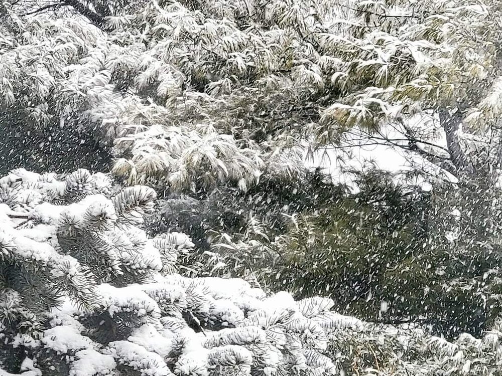
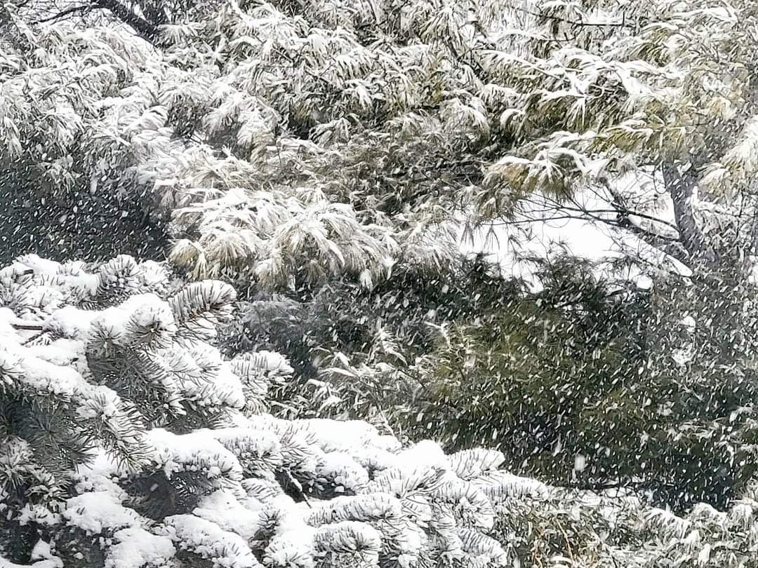
Looking good for 2-3", locally 4", across most of the GTA away from the lake, assuming temperatures can stay around the freezing mark or below. @mississaugasnow
Yep, biggest storm of the year here at my place. 3" with 5" on the ground. Temp has risen to 33F though
-
1
-
-
Looking like a solid 2-4" maybe 3-5" event for around here. Ill gladly take it
-
8 hours ago, Snowstorms said:
YYZ is still running a good 3C above average for Jan and next week's warmth will seal the deal for another warm January. Of the last 5 January's since 2019, only 2022 was below average lol. A one week long cold shot with no storm isn't going to change this winters grade from being an F - in my books. This cold shot has been nothing speculator either.
Hoping February is better, but it's looking to start warm.
Im already over the -16C or 4F nights. It will end up being about 13 days in a row with snow cover so I'll take that as a win as well.
Bring on top 5 least snowiest and spring.
-
1
-
-
1 hour ago, Malacka11 said:
Keeping it $1.50 with yall if I had to choose between another couple weeks of actual winter or getting the lake comfortably swimmable ASAP... I think unless the former actually delivers something historic, I'd have to choose the latter. Just feeling a little blue-balled still like @Baum said.
Ya, biggest storm here so far is 2.3" haha. Tuesday might beat it barely but Ill pass on another parade of cutters followed by 1-2" events in February
-
2
-
-
3 hours ago, Snowstorms said:
Extended GFS looking warm after early next week with mostly rain threats except maybe early next week due to the lingering cold HP in Quebec.
Chances of a futilty winter keep going up with each passing day. A wasted week of cold. @mississaugasnow
Ya, this period of cold and every other day light snow of 0.5" where I live has probably saved this from being an F winter.
I have about 3" on the ground now, river frozen, and another 1-4" system plus freezing rain coming Tuesday.
Averages are bottoming out right now at 30F for a high and quickly gain 6F to 36F in 5 weeks.
-
light snow has started here. Hopefully we see 3-7" over the two events
-
9 hours ago, Chicago Storm said:
really dawg... little desperate now.
haha weird timing for sure but Vancouver did get 6-10" today and lots of social media was showing Vancouver palm trees covered in snow.
-
Just now, Snowstorms said:
You do have a good point but for a long time while the "Toronto" station was operational, it was usually recording more than YYZ. And that "Toronto" station was in downtown near University of Toronto, if i recall, based on what another poster here was saying. It's been recording data since 1840.
I'll give you an example. That Toronto station recorded an astounding 84" during the 1959-60 winter vs 55" at YYZ. That 84" is a random winter that nobody has ever talked about, but it recorded more snow than the official snowiest winter at YYZ (1938-39) lol. And this is a downtown station, close to the lake too.
Based on that alone, YYZ has always been questionable. Buffalo's differences might be attributed primarily to lake effect as LES is always localized. Plus, unlike EC, NWS has like 10 stations per city lol.
Temperatures I do agree with and thats because of the urban heat island effect which is more profound in rural vs urban areas.
Ya, YYZ has been questionable throughout its history.
EC should have more official sites around GTA.
-
1
-
-
5 minutes ago, Snowstorms said:
I do agree. Areas much closer to the lake tend to be warmer and less snowier than areas further inland. This winter is a good example of that. However, mathematically speaking, YYZ and EC's headquarters are almost on the same plane. Both stations experience similar temperature's when it snows but vary during non-precip days.
I'm not sure if YYZ still uses the nipher because the differences have substantially improved and almost netted out to near zero over the last 6 years but man, 2004-2014 was really bad lol. I know for a fact 07-08 was unofficially the snowiest winter ever recorded at YYZ, but they lowballed the Mar 08 storm quite a bit. YYZ only recorded 6" whereas every station in the GTA recorded 13"+. Hence why North York has averaged around 51" over the last 29 years, which I feel represents many areas quite well around the 401 and north towards Vaughan minus northern regions of Vaughan like Maple, Teston, etc.
I remember that low ball haha
I guess since I’ve only lived in south Mississauga and now south of Hamilton the 40ish inches average always seemed right.
Next few years I’m going even further south to the shores of Lake Erie. Weirdly my average will go up to my highest ever lol
-
 1
1
-
January 2024 General Discussion
in Lakes/Ohio Valley
Posted
we've had 6 days but tons of days just a trace