

mississaugasnow
-
Posts
1,329 -
Joined
-
Last visited
Content Type
Profiles
Blogs
Forums
American Weather
Media Demo
Store
Gallery
Posts posted by mississaugasnow
-
-
2 hours ago, michsnowfreak said:
Snow showers yesterday and today have anywhere from a T-0.5" in SE MI.
I picked up 0.3" which was the first measurable snow of March for mby. Season to date is 40.1".
DTW also picked up 0.3", season to date 39.1".
It's been Torontos year this winter and one for the record books. So far 73" in Toronto and Im just over 50" (about 1 hour S)
-
 1
1
-
-
On 5/28/2025 at 11:37 AM, roardog said:
What is up with these Canadian wildfires every May? I understand a couple of years ago when Canada had that record or near record warm May. That would obviously cause the snow to melt and everything to dry up but not greened up yet. This year, the majority of Canada has had below normal temperatures this month. It seems all it takes anymore is a few “warm” days and you have spontaneous combustion of the forests. Are warmer and shorter winters causing more vegetation that then goes dormant for the winter allowing more fuel for the fires?
Nah its been really hot in Northern Canada (Northern Manitoba, Saskatchewan, NWT) Hay River NWT just broke the all time May record for the Territory with a high of 94F and there was still ice on the lake.
-
Ive given up on summer ever arriving haha. Lets just get to fall
-
 1
1
-
 1
1
-
-
2 hours ago, michsnowfreak said:
Agree. But this kind of weather helps, delaying the heat as long as possible. I dont mind summer when its shorter lol.
23 hours ago, michsnowfreak said:Fortunately I dont care what most like or want lol. I could do without the rain, but Im always a fan of cool temps.
See I agree but I dont think the board would be happy with me cheering for 50s and rain in January. You might even tell me to knock it off haha
-
 3
3
-
-
41 minutes ago, michsnowfreak said:
Since when does preferred weather make you sick in the head?
haha I think what hes saying is its the same as wanting 50s and rain in January. Most would say its depressing
-
 1
1
-
-
1 hour ago, michsnowfreak said:
Gray skies, sweater weather and fall feels in late may. No complaints here!
haha this spring sucks. Might as well just skip summer this year
-
1
-
-
On 4/10/2025 at 10:48 AM, michsnowfreak said:
Most areas got 1-2" but it was a weird event. Washtenaw and all but far NE Wayne county (the I-94 corridor from Ann Arbor to DTW) had a solid 1.5-2". Much of Lenawee county also had around 2", with northern Monroe getting 1-2" but then nothing at all in the city of Monroe due to Marine influence of the east wind off Lake Erie. Downtown Detroit into St Clair shores west to about Royal Oak, in a narrow band, also got no snow accumulation due to the wind off Lake St Clair, whereas west of St Clair and north to the rest of Detroits north burbs had around 1".
DTW had 0.42" precip and 1.8" snow. This brings the season total to 28.7", & the 1.6" I got here brings my season to 29.5".
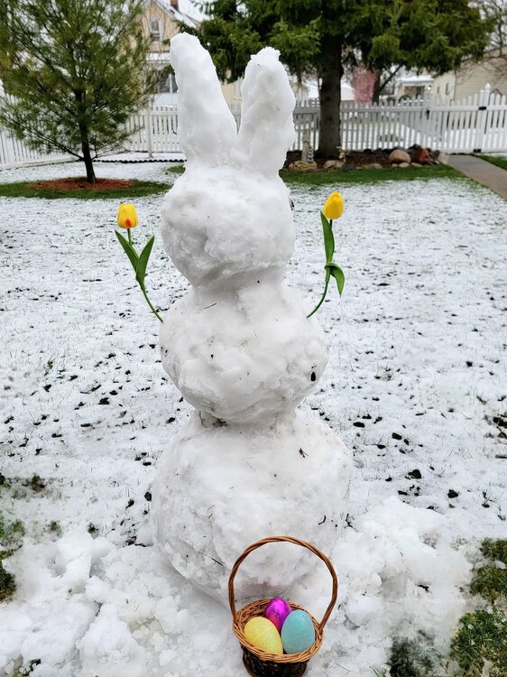
What started as a joke with my nephews is now a tradition, if theres snow during Easter season we make a snow bunny. Overnight was a true winter wonderland, but by daylight it was much more sloppy and slushy as youd expect.
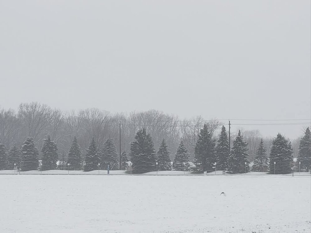

Im working over in Amherstburg and had some snow as well. Maybe half inch. It was gone by about 1-2pm but still a cold dreary day lol
-
1
-
-
5 hours ago, michsnowfreak said:
Looks like some snow chances in early March, with the ensembles honing in at this early stage on the March 5-10 period, then warmth by mid-month.
Never one to grade a winter until at least March is over, but what I can say about this winter is very clear: the cold and snowcover exceeded my expectations, and the snowfall & storminess fell short of my expectations. Would imply its floating in the C range at this time, will see what March brings.
I have lower expectations from the last few winters so this one gets an A. It actually starts to lose marks if I get 3-5" wet snow events in late March that melt before I finish my first coffee haha
-
1
-
-
I think my snowpack holds on but will be down to 3-5" by the end of the week. Looking forward to the mid 40s tomorrow
-
4 minutes ago, Snowstorms said:
About 3" yesterday with the initial wave here.
About 7" today so far with the main storm. A bit underperforming due to reasons aforementioned.
2" yesterday and 5" so far today (should get another 1" next few hours) Saw a few hours of heavy sleet as well this morning.
Should end up with a 2 day total of 8" which is the low end of the 8-14" forecasted but still awesome
-
21 minutes ago, michsnowfreak said:
Thanks. DTW is at 19.8" so far. Avg for entire season is 41" (longterm) to 45" (current 30 year normals).
This winter is unlike any we've seen in a long time. I found a few in the 1940s & 1960s similar. It's dominated by cold and dry and despite snowfall being below avg, there's been some presence of snow on the ground pretty much since New Year's (except for a dew days) but it's not yet reached 5" deep. Even late Nov to just before Christmas had many days of T-1" on the ground.
Im at 24.4" and have around 10-11" snow depth. Hamilton and Toronto have normally averaged close to the same but last few winters Torontos been winning by a lot
-
1
-
-
8 hours ago, Snowstorms said:
I don't think so. We're running several degrees colder than what was modeled at this current time. Even by the lake its sitting at -4C. Models had downtown at 0C (32F) right now.
Areas away from the lake might end up staying as snow.
Well that was a weird one. Went to bed with temps climbing fast. EC expected 36F by 7 am
At. 2am it peaked at 29.5F and quickly collapsed to 24F by 4am
woke up to 1.2” of sleet
storm total ended up being 4.1” with a glaze of freezing rain on all the trees
-
2
-
1
-
-
Goal is to limit melting. If it doesnt melt I'll have around 9-10" on the ground. Assuming a bit does this storm will be a wash and leave me at the same 7"
-
 1
1
-
-
1 minute ago, Snowstorms said:
How much snow did you get so far?
just under 3" and that will be all for this one.
-
1
-
-
10 minutes ago, Snowstorms said:
Mixing line (ice pellets/frz rain) advancing north towards Hamilton now. We'll see how far north that little warm nose goes. For now temps are sitting at 23.
3.2" at YYZ so far. Heaviest rates to come soon.
Ya, Im all freezing rain now
-
1
-
1
-
-
1 hour ago, mimillman said:
This is a really insightful comment
Could be worse I could be wishing for rain haha
-
Ideally this is 5-9" for me instead of the 3-5" todays is
-
2" and in the dry slot right now. I was thinking Id see 3-5" before freezing rain and light rain for a few hours so on track. Temps at 23F
-
6 hours ago, Snowstorms said:
Complex set up tomorrow for Toronto. Areas closer to the lake may switch over to freezing rain and rain but areas north of the 401 could stay predominately as snow. Temperatures are marginal, but sometimes models can underestimate the sneaky dynamic cooling plus the nearly frozen Lake Erie which may help to keep temperatures at bay. Certainly a nowcast event.
Early call is 6-8" north of the 401 and closer to 4" near the lake.
Ya, thats roughly what im thinking. My place is probably 3-5" followed by some freezing rain and rain. Just hoping it doesn't wash whatever falls all away.
Saturday right now looks like a slightly colder version of this one.
-
1
-
-
If I can get 3-5" and limit the rain with this one I'll be pumped. Toronto itself is in a better position for 5-9" and almost no rain.
-
1
-
-
9 minutes ago, michsnowfreak said:
Ill be pissed if we get an ice storm. The models will continue to waffle until it is fully sampled tomorrow (and even then, who knows). Every storm is unique so theres literally no telling what will happen.
Over here I’d love 2-3” and ice
just no rain. Rather ice storm instead
-
YHM was at 13.2" yesterday. My backyard was just above 14"
This storm will end up being 4-8" for us
-
1
-
-
1 minute ago, Snowstorms said:
Whats your seasonal average?
YYZ is at 20.6" as of yesterday. This storm should push YYZ to 25-26".
Pretty much Hamiltons. Im 5km away from Hamilton airport so 40-45"
-
1
-
-
1 minute ago, Snowstorms said:
That's awesome. Last year was a stinker for Hamilton. Will this storm help put you ahead of any futility records?
Yep, last year I saw 17" all season and I'll be at 19-20" once this ones done.
-
1
-


April 2026 General Discussion
in Lakes/Ohio Valley
Posted
Im thinking you guys will have snow on the ground (Canadian side as well) into May this year.