

mississaugasnow
-
Posts
1,237 -
Joined
-
Last visited
Content Type
Profiles
Blogs
Forums
American Weather
Media Demo
Store
Gallery
Posts posted by mississaugasnow
-
-
2 minutes ago, Snowstorms said:
I can't lie though, apart from 21-22, every winter since 19-20 we've been extremely lucky. 90% of the major snow fell with marginal temps. For example, temperatures were around 31-33F with that March storm last year that dropped 10-12".
And if we continue on this warming trend, it may just become feast or famine. And these two storms this week are exposing it nicely. 40+years ago if we had two sub 980 low's in a week, with a track like that, we'd be buried.
Ya, my new location has meant famine. We got 6" last March
-
 1
1
-
-
2 minutes ago, michsnowfreak said:
The Euro amd gfs could not be more different 24 hours out here.
I think, Ohio, SE Michigan and Southern Ontario (especially Lake Erie shoreline) are hoping the GFS wins out. It's been consistent with a band of 2-4" an hour rates for a while now.
-
1
-
-
Last 30 years has seen snowiest months and also 4 out of the 5 least snowy winters. This current one is on watch to join the club
-
 1
1
-
-
47 minutes ago, Snowstorms said:
@mississaugasnow I looked at the records to rank the snowiest month's on record in Toronto. I used North York since YYZ sucks. North York only has records going back to 1995 so the rankings are a combination of YYZ (pre 1997) and North York (post 1997). I filtered out any snowy month pre 1997 as I was only focused on the rankings for the last 20-30 years. So the rankings are from 1938-2023.
Note: If we were to hypothetically include all Toronto records that go back to 1840, then Mar 1870 takes the cake for the snowiest month on record, by far. A staggering 62" in one month lol.
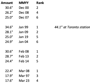
We can appreciate the fact that we've experienced the snowiest Jan (x2), Feb (x2), and Mar (x2) on record. Dec up there as well with 3 top 6, but Dec 1951 takes the cake with 34.1" (which btw was a moderate Nino).
So I wonder if that's the new normal going forward. A bit similar to I95 cities. Feast or famine starts to become typical
-
5 hours ago, Snowstorms said:
I think @michsnowfreak would go nuts if he experienced 4 of the top 5 least snowiest winters on record in a period of 10 years like we did in Toronto from 2006-2016. And if so, he can pull out any historic stat but I know there's nothing as unprecedented as experiencing 4 futility winters in 10 years.
That being said, February's are not as favorable for snow for our region as January is in El Nino's, especially strong El Nino's. But thing's can always change. Like how rare it is to get two sub 980 Low's in 4 days that both end up being cutters in an El Nino.
Im hoping we can get enough of a front end dump and backside 1-2" that we aren't fully looking at bare ground next week with the cold. Toronto saw 5cm yesterday so up to 23cm on the season.
-
Ya, no different for the eastern lakes. Looking near identical to the system that just went thru. Bring back the December pattern haha
-
 1
1
-
-
1 hour ago, Stebo said:
It would almost guarantee a below normal snow season here because cold and dry doesn't yield much snow even with some lake effect.
Im still thinking top 5 least snowy for Toronto but will most likely just end up top 10.
-
The GFS is keeping me barely in the game. One more slight push SE would do it
-
25 minutes ago, michsnowfreak said:
Yes, it is better. I'm also rooting for slightly weaker, however a stronger storm will not necessarily be a complete redo of this storm. The Arctic hounds are waiting in the wings behind Fri/Sat storm whereas there's no cold air with this storm. Of course all that said I definitely want slightly weaker.
But overall looks more fun for us on the east side of the forum to track
-
 1
1
-
-
19 minutes ago, michsnowfreak said:
Yes, it is better. I'm also rooting for slightly weaker, however a stronger storm will not necessarily be a complete redo of this storm. The Arctic hounds are waiting in the wings behind Fri/Sat storm whereas there's no cold air with this storm. Of course all that said I definitely want slightly weaker.
The arctic air wouldnt help eastern lakes though. Unless you're talking the difference being after the storm passes we go into the freezer. If thats the case to me its the same since its just a cold, snowless ground lol
-
3 minutes ago, Stebo said:
Yep, like I mentioned earlier, it will still be a good storm and most will get a good hit but these sub 970mb lows are a pipe dream, just like they were for the current system.
Isnt that better for SE MI? Im routing for a slightly weaker more SE trend. A stronger storm is just a redo of this current one
-
7 minutes ago, Lightning said:
I would plan a couple weeks active; then it will back off and a period of calmer/warmer (as we roll through the undesired MJO phases); then an active February (the question is where GL/OV or MA/EC or both).
Ideally MA/EC for those of us in eastern GL.
-
2
-
-
59 minutes ago, Snowstorms said:
You're right. The last few winters, although they've been above normal, we haven't been able to keep a snowpack because it's been so warm. And this winter so far is no exception. Last winter and 2019-20 are prime candidates. 21-22 was a solid A winter in my opinion. Jan 22 storm dropped a good 40-60cm (16-24") across the entire GTA.
The weekend storm has a lot of moving parts and variables so there's still time left for it to change. Should be a nice cold outbreak after the storm. But it may dry out for some time afterwards.
Ya, I'll pass on the cold and bare ground haha (I live south of Hamilton) Id rather a warm month instead of cold and dry with no snow on the ground lol
-
1 hour ago, Snowstorms said:
We still got lots of time left. YYZ at 6.9" as of yesterday. Below normal, yes, but that's to be expected in strong El Nino's. But not all strong El Nino's are the same.
We've been on a good run since 2017-18 with every winter above average and 21-22 being a top 10 snowy winter. A good turnaround from the preceding 11 years where we experienced 4 of the least 5 snowiest winters on record. Those were some brutal years man.
Tomorrow looks to be a good 2-4” for GTA before rain washes it all away in a few hours. 1-2” max down here.
Saturday storm looks like a redo of this current one. So Toronto is padding the stats but it’s gone within a few hours of falling.
This winters getting a F from me and I’m cheering for a top 5 least snowy lol. My actual guess is Toronto ends up with about 28” just outside top 5. Will have to look back at the records to see if it can be top 10 bad
-
1
-
-
9 minutes ago, Stevo6899 said:
Yea I dont know how a storm to our sw is a classic track for detroit snowstorms. I will say the block that stebo mentions seems to be flexing when the low gets to Indiana. If it can halt the low like the 12z gfs, it could be interesting.
I’m on your page here. Though it is a half decent track for you guys. You have no wiggle room though for any jogs NW
It’s a bit early but getting ready to toss the towel in over here in the eastern lakes
-
1
-
-
Lol Toronto is going to get back to back cutters that help prop up their seasonal total but turn to rain within a few hours of the onset.
still looking good for a top 5 least snowy winter because of the western cutters
-
You guys are crushing it in the Midwest. This is another yawner for eastern lakes (outside of lake effect)
-
15 minutes ago, andyhb said:
18z GFS is super weak and south, we’ve come full circle.
Gives Ohio, WNY and Southern Ontario a decent hit
-
That was a pretty good run for most of the Great Lakes region.
-
1
-
-
3 hours ago, nwohweather said:
I don’t recall if I’ve ever seen a 60+ mb gradient in my life quite like that. 1045 MB high in WCAN and a 970 MB low rushing through the GL is prolific. The thing that made ‘78 so special was that the arctic jet was basically brought down to the surface, wind gusts topped 100 mph over Lake Erie with sustained winds topping out at 80 in Cleveland
The winds could be awesome for seiche in Erie.
But overall that was maybe the worst run of the gfs ive seen haha. Central and Western Lakes cash and Eastern Lakes gets nothing. Id rather warmth instead of cold and bare ground haha
-
1 hour ago, Stevo6899 said:
I think that next storm, if it's as strong as depicted now, will go nw, just like next week's. We need a gulf low or something come out of south Texas. These lows that come outta the rockies/4 corners/panhandle go negative tilt too early for metro detroit to get in on the goods.
I agree, not sure about west Michigan but the Detroit-Toronto-Niagara corridor will be hard pressed to get a big snowstorm. Toronto might sneak in a 1-4” Lake enhanced snow tomorrow night.
Not saying it can’t happen but let’s cool the jets a bit on widespread 1-2 feet coming the next 10-14 days lol.
-
1
-
-
January 2016 seems similar at Toronto where it looks like we got heavy rain followed by cold, brief warm up, 1.5" of snow and then below freezing for a week but nothing crazy cold. Will be interesting to see if it follows the same script
-
Mostly Rainer here on the early-mid week system. The next one at day 7-9 might have some potential. Certainly not believing those snow maps hahaha
-
14 minutes ago, sbnwx85 said:
Went from the northern edge of the best snows at 12z GFS to nearly being all rain on the 18z GFS. Split the difference, right?
well that was a gross run for my area. Lots of rain
Jan 11-13th Blizzard
in Lakes/Ohio Valley
Posted
What are your thoughts on the GTA/Niagara?