

NavarreDon
-
Posts
2,890 -
Joined
-
Last visited
Content Type
Profiles
Blogs
Forums
American Weather
Media Demo
Store
Gallery
Posts posted by NavarreDon
-
-
Happy for all who cashed & especially those who over preformed! I’m really liking the pattern for the next couple weeks so, I might pop in or stick around.
.-
 3
3
-
 1
1
-
-
-
I'll wait until tomorrow morning to post my assessment but it seems like I was wrong about the NAM. I'll admit that I should have looked at it harder. I'm still happy with today though.
I’m really surprised also, it may end up with the N Mnts being the winners from this one. I certainly have some egg on my face at this point.
.-
2
-
-
New Mesoscale Discussion....
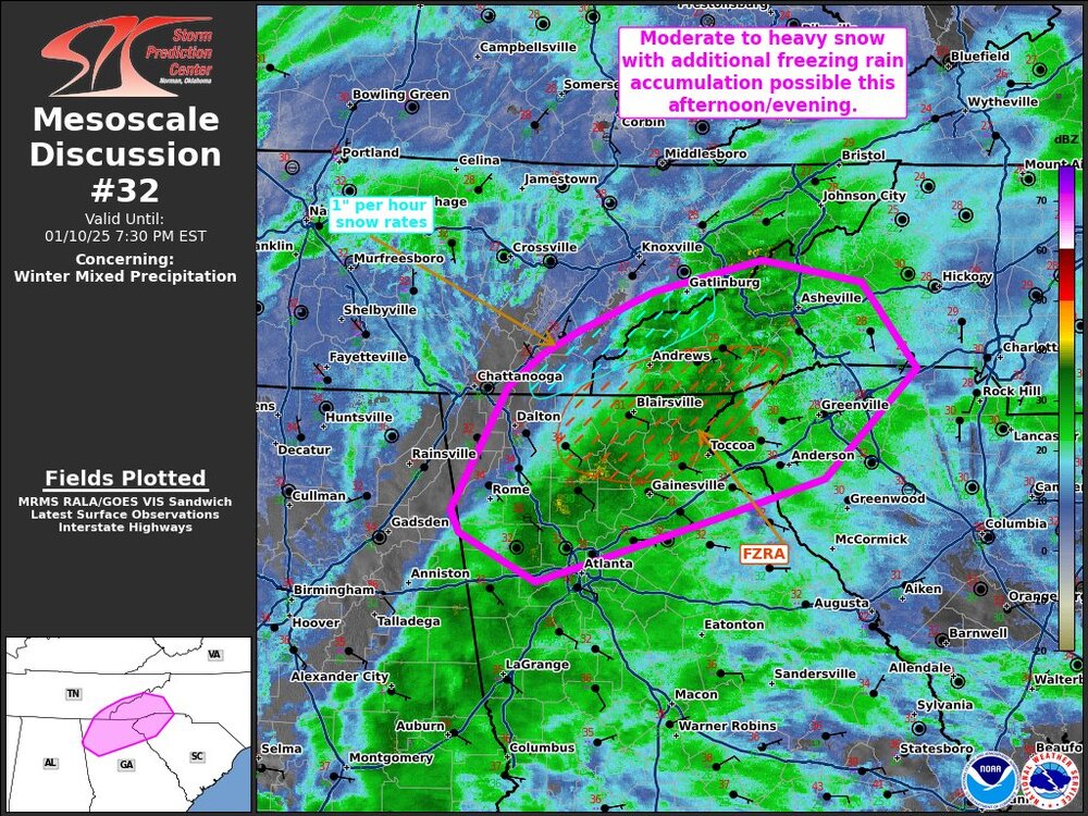
Here is the long version, sorry for the length!:
Mesoscale Discussion 0032
NWS Storm Prediction Center Norman OK
0330 PM CST Fri Jan 10 2025
Areas affected...northern Georgia...eastern Tennessee...far western South Carolina...western North Carolina
Concerning...Winter mixed precipitation
Valid 102130Z - 110030Z
SUMMARY...Areas of moderate to heavy snowfall along the high terrain and mixed precipitation likely in the afternoon/evening across portions of east TN/north GA and western SC/NC.
DISCUSSION...A broad region of heavy precipitation continues to shift northward across northern Alabama into eastern Tennessee/northern Georgia beneath enhanced mid-level flow and forcing from an upper-level trough. This precipitation shield will continue to lift north and eastward this evening, bringing an increase in the precipitation rates across the region, extending into western North Carolina through time. Moderate to heavy snowfall will be possible (with occasional 1" hr rates) across the southern Appalachian Mountains in eastern Tennessee. Further south across northern Georgia into the western Carolinas, profiles will continue to support additional accumulations of freezing rain. NAM/RAP sounding analysis across northern Georgia into South Carolina show a warm nose at 850 mb with surface observations indicating temperatures remain in the upper 20s to 30s. Occasionally, mixed precipitation/sleet will be possible.
.-
3
-
-
2.5” is the report from my brother’s hood up the Mnt outside of Glenville.


.-
6
-
-
Congrats folks! Gonna need lots of pics!!!
.-
2
-
-
GSP all in on the NAM. Also believe the precip minimum in the Aville valley. They could be right. Multiple models not showing a significant precip minimum. That minimum is modeled on more precip events than I care to remember. It has also been incorrect many times and Aville and Buncombe has over performed. We shall see. Let's just start with that 1st flake and go from there.
https://forecast.weather.gov/product.php?site=GSP&issuedby=GSP&product=AFD&format=CI&version=1&glossary=1&highlight=off
Ahh the memories!!! Which way will the pendulum swing? Hoping it’s towards the over performing end for you Jason, you’ve paid many a dues!
.-
1
-
-
Thermal Profiles look a bit better than forecasted out west. This could bode well for some of you guys.
.-
2
-
-
-
Temps are razor thin on the NAM 3km. IMO going to take more than 500-750ft in the atmosphere of temps above freezing to full melt, especially with how cold the surface is. Thinking the NAM may have qpf close, but thinking temps might be causing the model to believe its sleet, but in reality it will fall as heavy snow with big flakes that stick together. Just my opinion, hope everyone is doing well!
+1 on this, really good analysis!
.-
3
-
-
Evening all! Been busy all day but wanted to say a couple things from afar. Try not to be guilty of model hugging. Use historical data as well. There a so many variables in a system like this one. Even Mets are unsure what will happen. Personally using the above I think the storm will meet or exceed expectations for the most part in the Mnts. Enjoy the next 36 hours as much as you can because the chase is what we all live for. Good luck to all of you!!!
.-
3
-
1
-
-
Great pics up above this post as well as below!
More good news from MOB’s afternoon AFD + my forecast for Friday below
AFD snippet:
Plenty of moisture and forcing will
allow for precip chances to increase rapidly throughout the
period. With no instability in place, expecting this event to
primarily be a widespread stratiform precip shield as opposed to
convection.
Friday forecast:
A chance of rain before 9am, then showers, mainly after noon. The rain could be heavy at times. High near 63. East wind 10 to 15 mph becoming south in the afternoon. Winds could gust as high as 25 mph. Chance of precipitation is 90%.
.-
2
-
 1
1
-
-
Haha! Thanks but I’m still in SC. Now I’m between Seneca and Walhalla. Above 85 and just above hwy 11 sitting right at 1000’-1100’ ft elevation

I used to travel Hwy 28 thru that area back in the day. That’s a nice spot to be in, thinking you might escape the mixing zone but it’ll be close.
. -
My first Miller A here in the foothills

Not sure of your location and elevation as I don’t follow the board like I used to (congrats on the move from SC!). I think the warm nose may come into play in some of the foothills, that being said I’d bet you get your wish of snowballs & sledding. Grab some popcorn and enjoy the show!!!
.-
1
-
1
-
-
If I was up in the Mnts. My concern with gulf coast convection would be heightened if this was a monster storm. This one doesn’t seem to support it but you never know. Always a good idea to read up on downstream AFD’s. Below is a snippet of MOB’s overnight disco. These Mets are some of the best I’ve seen with severe weather. Long story short is I don’t see it being an issue for you all.
The surface low
will briefly bring a warm front into the coastal counties before
a cold front follows quickly behind, but no tangible instability
will accompany what will be a rather meager warm sector.
.-
5
-
-
This looks solid from the 00z gfs.
.thumb.jpg.ce519dd94ff6501e3fbb73545547513c.jpg)
Sent from my SM-G998U using Tapatalk
Looks like a classic Miller A to me. I think the GFS and Canadian are sniffing this out. Questions will be, the Low track and how much moisture accompanies it. Changes always occur but this looks great for the Mnts. It doesn’t look like a monster but my early guess is there will be some OBS with 6”+ from the system.
.-
4
-
-
Good afternoon Mnt peeps! Hope you had a blessed holiday season. My prayers are for a continued recovery in the region!
My snow spidey sense is going off about the upcoming weekend event. Historically & synoptically this set up provides the Mnts and to an extent the foothills a decent snow. There is still a lot to iron out but someone is probably going to have some fun. Hope you don’t mind if I pop in every now and then to give my 1.5 cents worth.
.-
8
-
1
-
-
Very likely we have a TS very soon if not already.

.-
2
-
-
There is a decent debris signature west of Tradition & PSL for the observed warning.
.-
1
-
-
Tornadoes are really ramping up now. As discussed earlier some of these are not your typical hurricane spawned rotations.
https://x.com/weatherwithlaur/status/1844037683829710958?s=46&t=0ZvB_AF2VfA6c0SDxf53yA
.-
3
-
 2
2
-
-
-
-
I’ve never seen a cat 4 or 5 have a second peak after an ERC higher than the first from what I remember. It’s probably happened at some point but it’s rare
Didn’t Ian do that?
(Edit it was @ 120mph prior to the ERC and then rapidly intensified to 160mph)-
4
-
-
Wow!!!
Hurricane Milton Discussion Number 10
NWS National Hurricane Center Miami FL AL142024
1000 AM CDT Mon Oct 07 2024
Milton's remarkable rapid intensification is continuing. Satellite
images show a small eye within the very cold central cloud cover,
and the eye is becoming better defined. Data from the Mexican
radar at Sabancuy show a small, closed eye with an intense eyewall
presentation. The Hurricane Hunter aircraft earlier reported a peak
flight-level wind of 146 kt, and dropsonde data show that the
pressure has fallen to around 933 mb, which is down about 22 mb in
4 hours. The initial wind speed is set to 135 kt, which is an
80-kt increase in 24 hours (only eclipsed by Wilma 2005 and Felix
2007 in our records).
.-
7
-
1
-


.jpg.123c4e251cbe7e089d5f255beb1e5486.jpg)

2024-2025 Fall/Winter Mountain Thread
in Southeastern States
Posted
12Z Euro is the stuff dreams are made of!!!
.