.jpeg.334887ee505ee3a32ba3405431f39d37.jpeg)

Seminole
-
Posts
318 -
Joined
-
Last visited
Content Type
Profiles
Blogs
Forums
American Weather
Media Demo
Store
Gallery
Everything posted by Seminole
-
We stayed beachfront (Bungalow Beach Place) in Indian Shores in 2021 during Hurricane Elsa. There was no flooding and it was a non event. This looks to be of similar intensity and track in the GOM. I would not be afraid to ride it out as long as the projected intensity stays the same.
-
Low Country and OBX is in for some serious coastal erosion with this run.
-
Land friction will keep RI in check.
-
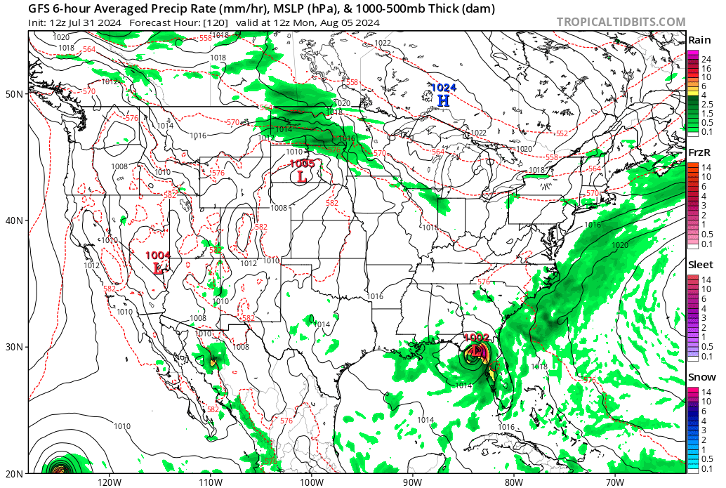
The 6Z GFS is something to behold. Genesis off Ft. Myers coast Sunday High end TS into Nature Coast on Monday TS off the Savannah coastline Tuesday CAT 1 well off the Jacksonville coastline Wednesday CAT 2 hits Jacksonville Thursday TS over Tallahassee Friday TS over Tallahassee Saturday TS back in GOM south of Cape San Blas on Sunday TS north of Mobile Bay Monday
-
The 00Z runs are all over the map. One common theme is frog strangler amounts of rain for Florida. As for the stall over water, I would think upwelling will cap out intensity which the Euro hints at.
-
2024 Atlantic Hurricane Season
Seminole replied to Stormchaserchuck1's topic in Tropical Headquarters
12Z GFS weaker and into the Apalachee Bay/Florida Nature Coast. Trending toward the Euro solution with this run.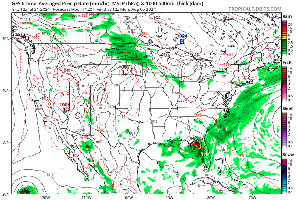
-
2024 Atlantic Hurricane Season
Seminole replied to Stormchaserchuck1's topic in Tropical Headquarters
6Z GFS just got interesting. High end CAT 1 to low end CAT 2 hugging the panhandle shoreline for days and finally makes landfall in Mobile Bay.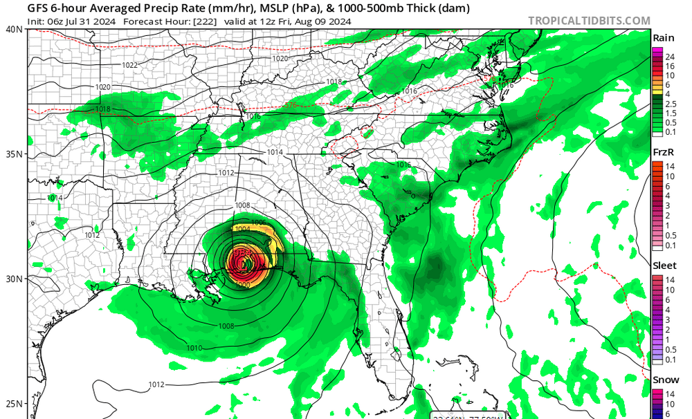
-
2024 Atlantic Hurricane Season
Seminole replied to Stormchaserchuck1's topic in Tropical Headquarters
That is a lot of SAL to navigate through.
-
2024 Atlantic Hurricane Season
Seminole replied to Stormchaserchuck1's topic in Tropical Headquarters
SAL is a real problem right now in the Caribbean basin. By next week the Caribbean basin plume will be in the GOM and another large plume is moving toward the MDR and will migrate westwards. Until the SAL diminishes I think this current pattern holds at least another 2 weeks. -
2024 Hurricane season forecast contest -- results now posted
Seminole replied to Roger Smith's topic in Tropical Headquarters
22 Named Storms 11 Hurricanes 3 Major Hurricanes -
I have seen pictures of Killearn Estates after Hurricane Kate in 1985 and the roads were impassable. Oak tree after oak tree across the roads. Hemine, Irma and Michael were child's play compared to what Kate did to Tallahassee.
-
Seems to be the case more often than not.
-
000 WTNT45 KNHC 282052 TCDAT5 Tropical Storm Idalia Discussion Number 9 NWS National Hurricane Center Miami FL AL102023 400 PM CDT Mon Aug 28 2023 The satellite presentation of Idalia has continued to improve this afternoon. The center of the storm is embedded within an area of deep convection with cloud tops colder than -75C. Although the early reconnaissance aircraft and radar data from Cuba have not yet indicated the presence of an eyewall, the aircraft data did indicate that the pressure had fallen to around 987 mb on the final pass through the center earlier this afternoon. Believable SFMR winds of 60 kt were reported to the east of the center, and Idalia's intensity was raised to that value on the 1800 UTC intermediate advisory and it remains at that value for this advisory. NOAA and Air Force Reserve Hurricane Hunter aircraft are scheduled to be in the storm environment again this evening and should provide additional information on the structure and intensity of the tropical cyclone. Another NOAA G-IV synoptic surveillance mission is underway and that data should be assimilated into the dynamical model runs this evening. Idalia is moving northward or 360/7 kt. The storm should continue to be steered northward between a mid-level trough over the central Gulf of Mexico and a ridge near the Greater Antilles through tonight. On Tuesday, a faster north-northeastward motion should begin as a trough moves into the east-central United States. This motion should bring the center of Idalia to the Gulf coast of Florida on Wednesday. The dynamical models continue to have some spread after 36 hours, with the GFS and HAFS guidance along the western side of the envelope and the ECMWF along the eastern side. The consensus aids were slightly west of the previous cycle, and the NHC forecast has been nudged in that direction. The NHC track forecast is in best agreement with the HFIP corrected consensus model. It is still worth stressing that only a small deviation in the track could cause a significant change in Idalia's landfall location in Florida due to the paralleling track to the west coast of the state. When Idalia nears the Atlantic coast of the southeastern United States the guidance suggests the cyclone will turn more eastward as the aforementioned trough passes to the north of the storm. The upper-level wind pattern is forecast to become more conducive for significant strengthening when Idalia moves over the southeastern Gulf of Mexico tonight and Tuesday. At the same time, the storm is forecast to move over an area of high ocean heat content. These conditions are likely to allow for a period of rapid strengthening which is explicitly shown in the official forecast through 36 hours. Idalia is likely to become a hurricane this evening, and is predicted to become major hurricane over the eastern Gulf within 36 hours. The NHC intensity forecast is just a little above the latest HFIP corrected consensus guidance. Idalia is forecast to move into an area very susceptible to storm surge, and regardless of the cyclone's landfall intensity, there is increasing confidence of a significant storm surge event. KEY MESSAGES: 1. There is a danger of life-threatening storm surge inundation along portions of the Florida Gulf Coast where a Storm Surge Warning is in effect, including Tampa Bay and the Big Bend region of Florida. Inundation of 8 to 12 feet above ground level is expected somewhere between Chassahowitzka and Aucilla River. Residents in these areas should follow any advice given by local officials. 2. Hurricane conditions are expected within portions of the Hurricane Warning area along the Florida Gulf Coast, with the potential for destructive winds where the core of Idalia moves onshore. Strong winds will also spread inland across portions of northern Florida near the track of the center of Idalia. 3. Areas of flash and urban flooding, some of which may be locally significant, are expected across portions of the west coast of Florida, the Florida Panhandle, and southern Georgia Tuesday into Wednesday, spreading into portions of the eastern Carolinas Wednesday into Thursday. 4. Hurricane-force winds are expected across portions of far western Cuba tonight. Heavy rainfall is also expected across portions of western Cuba and may produce areas of flash and urban flooding as well as landslides. FORECAST POSITIONS AND MAX WINDS INIT 28/2100Z 21.4N 85.1W 60 KT 70 MPH 12H 29/0600Z 22.7N 85.2W 75 KT 85 MPH 24H 29/1800Z 24.9N 85.0W 90 KT 105 MPH 36H 30/0600Z 27.6N 84.4W 105 KT 120 MPH 48H 30/1800Z 30.4N 82.9W 80 KT 90 MPH...INLAND 60H 31/0600Z 32.7N 80.4W 50 KT 60 MPH...INLAND 72H 31/1800Z 34.0N 76.8W 50 KT 60 MPH...OVER WATER 96H 01/1800Z 34.1N 71.4W 45 KT 50 MPH 120H 02/1800Z 34.0N 69.0W 45 KT 50 MPH $$ Forecaster Brown
-
An eyewall over Tallahassee would mean power outages for 95% of Tallahassee. The power grid in that town has miles and miles of power lines intertwined with Canopy roads the service large sections of the population.
-
My understanding is that Zone A in Pinellas is under mandatory evac order.
-
Thank you. Given my proximity I am hanging on every model update. Going to decide tomorrow to ride it out or bug out.
-
Expected this given the 0Z was off with intensity this morning. Any shift in landfall?
-
-
The 12Z GFS is another trend toward the Euro solution. The timing of the trough that picks up Idalia will be crucial to whether this is a Forgotten Coast or Nature Coast strike.
-
Safe to say this one has a long way to go.
-
https://abc-7.com/news/2022/09/27/lee-county-announces-mandatory-evacuations/
-
What is Zone 3? The evac Zones are A thru E. I can tell you that Zones A thru C were told to evacuate. https://www.leegov.com/publicsafety/emergencymanagement/knowyourzone
-
To go 20 miles inland? Come on.
-
Completely untrue. The mandatory evacuation orders went out yesterday.