.jpeg.334887ee505ee3a32ba3405431f39d37.jpeg)

Seminole
-
Posts
318 -
Joined
-
Last visited
Content Type
Profiles
Blogs
Forums
American Weather
Media Demo
Store
Gallery
Everything posted by Seminole
-
2024 Atlantic Hurricane Season
Seminole replied to Stormchaserchuck1's topic in Tropical Headquarters
6Z GFS further west and misses the GOM loop current. Still a solid CAT 3 with a massive wind field. Landfall near Port St Joe. -
2024 Atlantic Hurricane Season
Seminole replied to Stormchaserchuck1's topic in Tropical Headquarters
A perfect run where the TC crawls along the loop current and explodes. -
2024 Atlantic Hurricane Season
Seminole replied to Stormchaserchuck1's topic in Tropical Headquarters
The Euro has stayed steady with the trough not influencing the potential TC. -
2024 Atlantic Hurricane Season
Seminole replied to Stormchaserchuck1's topic in Tropical Headquarters
Massive!
-
2024 Atlantic Hurricane Season
Seminole replied to Stormchaserchuck1's topic in Tropical Headquarters
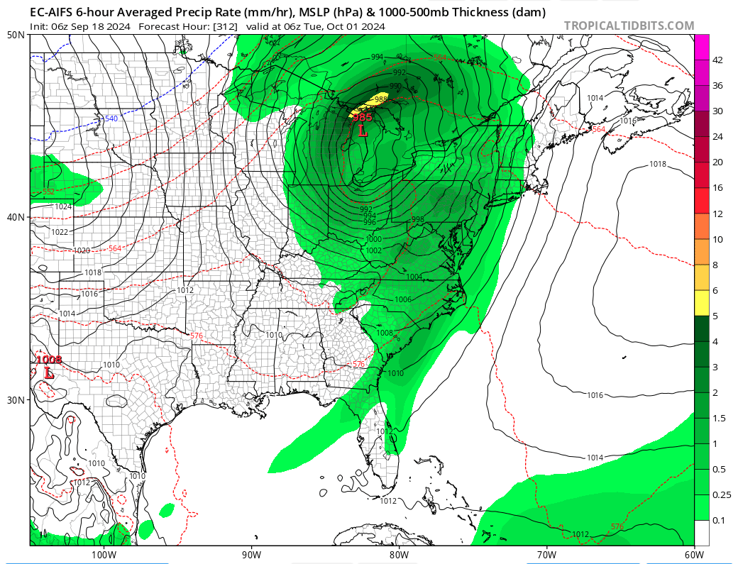
If I am interpreting the 6Z GFS correctly. We have a high end tropical storm off the Panama City coast that somehow drifts south east and proceeds into the Apalachee Bay as a low end CAT 1. It then maintains high end tropical storm intensity to though the entire eastern seaboard and then regains hurricane intensity over Pennsylvania and New York (Subtropical?). -
2024 Atlantic Hurricane Season
Seminole replied to Stormchaserchuck1's topic in Tropical Headquarters
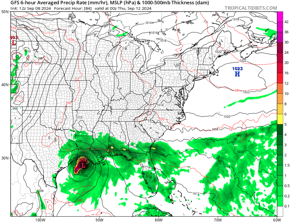
The GFS has been all over the gulf coast of Florida the last 3 runs. Naples 00Z. Pensacola 06Z. Split the difference with Tampa 12Z. The 00Z run was interesting because after it crosses over Florida it hugs the entire eastern seaboard as a solid CAT 3 all the way to New York. -
Potential Tropical Cyclone Eight—50mph/1006mb
Seminole replied to WxWatcher007's topic in Tropical Headquarters
I have all of that going for me and still ended up with 8 inches of water under my house from the complete inundation we have had for almost two weeks. The amount of water on our island rivals what we had with Michael in 2018. Granted some of that water from Michael was storm surge. This was purely a rain event in the Florida Big Bend. Absolute frog strangler rain event. -
2024 Atlantic Hurricane Season
Seminole replied to Stormchaserchuck1's topic in Tropical Headquarters
Interesting that the anomalous readings this year are located in the vicinity where the ITCZ moved to. I believe the ITCZ was cited as misplaced 150 miles north of where it normally is. -
The path Francine took brought it over some the hottest SST's in the GOM. Definitely was a factor in RI.
-
2024 Atlantic Hurricane Season
Seminole replied to Stormchaserchuck1's topic in Tropical Headquarters
A heated Troposphere due to increased sunspot activity could definitely be a factor in the long lull of TC activity because of atmospheric stabilization between all layers of the atmosphere. The sunspot activity is now waning and we are now seeing a resumption in TC activity. Coincidence or not it still warrants consideration as a possible cause for the TC lull despite all the other favorable conditions for development. -
2024 Atlantic Hurricane Season
Seminole replied to Stormchaserchuck1's topic in Tropical Headquarters
It definitely is worth considering. The Maunder Minimum coincided with Little Ice Age. Sunspot activity or lack thereof definitely has an effect on weather and volcanism. -
A picture is worth a thousand words. That environment is very hostile tomorrow. I would not be surprised if a tornado watch is issued for areas east of landfall. This setup has all the makings for tornadic activity in the outer bands.
-
The 12z GFS seems to agree with you.
-
2024 Atlantic Hurricane Season
Seminole replied to Stormchaserchuck1's topic in Tropical Headquarters
except 91L. -
2024 Atlantic Hurricane Season
Seminole replied to Stormchaserchuck1's topic in Tropical Headquarters
The 6Z run has multiple instances of waves that just fluctuate across the Atlantic basin until one finally gets its act together east of the lesser Antilles around the 15th. Who knows? -
2024 Atlantic Hurricane Season
Seminole replied to Stormchaserchuck1's topic in Tropical Headquarters
Those 540 lines are telling. South Florida and Texas are still in play for a major but the rest of the lower 48 the odds of a major is diminishing rapidly. -
2024 Atlantic Hurricane Season
Seminole replied to Stormchaserchuck1's topic in Tropical Headquarters
The 6Z GFS out to September 21 with nothing significant. The amount of rain that is forecasted for the northern GOM during this period will cool off the SST's. Not a season cancel, but the odds of a tightly wound GOM monster major are trending toward unlikely. -
2024 Atlantic Hurricane Season
Seminole replied to Stormchaserchuck1's topic in Tropical Headquarters
The fact we are discussing ST storms in early September seems misplaced and exemplifies how strange this season has gone. -
2024 Atlantic Hurricane Season
Seminole replied to Stormchaserchuck1's topic in Tropical Headquarters
Or complete Bizzaro World and have University of Miami predict snow packs.
-
2024 Atlantic Hurricane Season
Seminole replied to Stormchaserchuck1's topic in Tropical Headquarters
How in the world do CSU have any credibility at all with that poor a track record? They consistently over estimate and the media hypes their over estimate every year. -
2024 Atlantic Hurricane Season
Seminole replied to Stormchaserchuck1's topic in Tropical Headquarters
Factors like solar activity and volcanic activity are not data points used in the models. Both impact weather. -
2024 Atlantic Hurricane Season
Seminole replied to Stormchaserchuck1's topic in Tropical Headquarters
Some interesting snippets regarding the 2022 Tongo volcano and how it may be related to what is going on with the ITCZ and Hadley Cell. Solar Activity also cited as a possible culprit. https://www.zerohedge.com/weather/atlantic-tropics-are-completely-broken -
2024 Atlantic Hurricane Season
Seminole replied to Stormchaserchuck1's topic in Tropical Headquarters
None that I can recall. Everyone was on board the hyper active year bandwagon. -
2024 Atlantic Hurricane Season
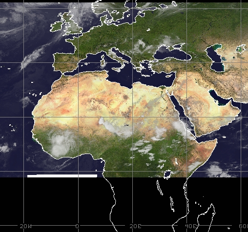
Seminole replied to Stormchaserchuck1's topic in Tropical Headquarters
No one seems to know what is wrong. I do find it interesting that the Sahara is experiencing years worth of rain during this quiet period of no named storms. -
2024 Atlantic Hurricane Season
Seminole replied to Stormchaserchuck1's topic in Tropical Headquarters
Nothing to write home about behind that wave though.