
nrgjeff
-
Posts
3,643 -
Joined
-
Last visited
Content Type
Profiles
Blogs
Forums
American Weather
Media Demo
Store
Gallery
Everything posted by nrgjeff
-
Clayton, GA and Black Rock Mtn SP might be a good view, though not right on the center line. Parts of the Cumberland Plateau in Tenn would offer nice views. Both locations might avoid Great Smoky Mountain NP crowds. Still, both may be quite busy too. May plan A is to head northeast for Chatty, perhaps finding a ridge but I do not see a need for a high mountain view. Wide sky is favored, and just high enough to maybe see the shadow move. Few clouds or better I will stick with Plan A so it can be a family event. Scattered clouds becomes a gamble if one covers the sun/moon those 2 minutes. Plan B is to head to points north and west the day before if bad weather is forecast. Silly me never got around to booking motels a year ahead, as I promised myself in this very thread, and the clock is running out. However we have some options within an hour of the path all the way back to the KC metro. Plan C is 2024, lol! That one is in April when weather is more fickle; so, it would be nice to avoid any unforced errors this year. Maybe I should be planning more for such a rare event, but for now I'm treating it like storm chase. Plan, but don't over analyze if 30 minutes from the path.
-
Camping in rural areas also offers the added benefit: Get out the scopes the night before or after for other viewing. I think we will book 1-2 hours off path and position early morning. It is a gamble, hopefully no worse than chasing central Oklahoma, lol! If the weather looks good here it will be a local project, which is my wish. I'm not sure I'd go for a scenic spot due to crowds. A total eclipse will blow your mind even on the flattest plains. Think parking lots of churches, schools, hospitals, anything not really commercial and with low risk of getting booted.
-
I had planned on booking 3-4 motels from here to the High Plains as cloud insurance, but procrastination struck. SC booked? Hopefully the Plains is not. Probably got places to stay along the way to at least KC if not a motel. Actually another total solar eclipse comes in 2024. They are streaky. Nothing for 40 years and then two in several years. Still traffic and motel rooms could make a storm chase in central Oklahoma seem like light traffic.
-
Louisiana tornado situation is getting more serious today (Tue Feb 7) with confirmed tornadoes either by debris sig or observation. Gulf Coast boundary is pronounced as it lifts north bringing higher theta-e air, and low level winds are the right direction considering what is going on upstairs. At first glance 700/850 mb appear veered off, but not so relative to other levels. Winds at 200/500 are from the northwest and west-northwest; so, the whole profile has a lot of turning. Surface to upper levels is a classic hodograph, just rotated about 30-45 degrees.
-
Might be mainly straight line winds from Texas to Kansas, vs tornadoes. Farther the low tracks north, the less direct it can tap the Gulf. Instability looks even lower now. Plenty of kinematics will be available for wind though. Now I figure something got lost in translation, text only over the Internet. You are not questioning my enthusiasm for severe weather? Would be pretty ironic from the Texas Storm Chasers, lol!
-
12Z model suite is friendly to the SPC Day 5 valid Sunday. Low CAPE high shear severe is not limited to Dixie Alley at night. Recent studies show such events as frequent or even more frequent in the Plains all times of day. Sunday looks like robust speed shear with adequate directional shear. Dewpoints are just-in-time, a concern in spring but just the way it goes in winter. Figure helecity will be locally higher on the lifting warm front. If it is not going to snow for Christmas, why not severe?
-
Central/Western Medium-Long Range Discussion
nrgjeff replied to andyhb's topic in Central/Western States
If the current weather pattern holds, troughs Central and Southeast ridge, the Midwest fall/encore severe season could be at least somewhat interesting. PDO and ENSO analogs favor at least semi-persistence. Weeklies keep ridging East or Southeast with occasional troughs Central. Naturally Rockies troughs would be ideal for the Plains but most seem to be forming Central. Corn Belt can and occasionally does deliver in fall. I prefer September with the longer days but the above PDO/ENSO analogs have some trough west ridge east in October. My other reason for a September focus, is something other than the heat dragging on locally here in the Tennessee Valley. Living vicariously in the Midwest... -
Probably time to think about booking a few motels along the route in case it is cloudy here. Make Eclipses Great Again!
-
Central/Western Medium-Long Range Discussion
nrgjeff replied to andyhb's topic in Central/Western States
Welcome to the Forum and Central/West. Actually I find temperature forecasting quite interesting during the summer in California. One has to look at the marine layer from the coast into the valleys and the sea breeze later in the day. I find Southern California more forgiving. Some days a marine layer or sea-breeze forecast error can negate the other, saving a daily temperature forecast but the hourly may be a mess for a few hours. Northern California coastal valleys can be particularly unforgiving if one blows the marine layer and/or wind direction. Monsoon pattern also offers good forecast challenges. While temperatures do not make for good drama on a forecast forum, it is still interesting to follow. Otherwise, live vicariously in the Plains for some real weather action. Again welcome to the board and region. -
Central/Western Medium-Long Range Discussion
nrgjeff replied to andyhb's topic in Central/Western States
Today should mark the beginning of a 7-10 day stretch of surprisingly good storm chasing so late in the season. Thank the Nino to Nina transition, reaching neutral by late spring. Jet stream is active from the Pac NW across the US/Canada border. SPC already has the box out for western Minnesota today. Distinct boundary offers a focal point for severe, perhaps tornadoes on a dominant cell. Wednesday looks like a good upslope day, from the boundary in northwest Kansas north into the upslope flow. Thursday should be active on the warm front in Iowa, but maybe sloppy. Friday could be the day-before-the-day in MT/ND. Saturday should be active with a defined system approaching North Dakota. LLJ responds to upper jet and moisture returns quite well. I would use Thursday to reposition for Friday, after the Wednesday target. One could argue Friday is the repo day if going from Iowa Thursday to ND Saturday. If I were really chasing I would try upslope Wednesday, repo Thursday, and be in MT/ND Friday. Don't forget the passport Fri/Sat. Sun/Mon the Saturday system lumbers northeast into Canada probably becoming meridional. Later next week another system is possible across the far northern US and/or on the Canadian border. -
Nice work Quincy! Looking back at my Colorado post, I kind of brushed over the main outflow boundary buried south (in West Texas). Subtle other boundary lifted north for the Trinidad TOR. However it was the main OFB (farther south) from the Oklahoma MCS that lifted north through AMA. With enough upper air support, and a responding LLJ, enjoy Texas Panhandle magic.
-
The MCC in Oklahoma has created a train wreck this morning (Monday). Still a chance things recover in Colorado; note 12 hours of sunlight to go as I type. Temps/Dews should be adequate by late afternoon. LLJ looks just-in-time JIT but tries late afternoon. With the main outflow boundary buried to the south Palmer Divide topography may have to work on its own. Outflow lifting back north may be better aligned with Raton Mesa topography late this afternoon. Despite JIT recovery, I think it is at least a local set-up in Colorado.
-
Central/Western Medium-Long Range Discussion
nrgjeff replied to andyhb's topic in Central/Western States
GFS ensembles and CFS weeklies should be available at NCEP or many free models sites. Euro ensembles and Euro weeklies usually require a subscription somewhere. Euro op is starting to show up on a few free sites though. -
Central/Western Medium-Long Range Discussion
nrgjeff replied to andyhb's topic in Central/Western States
Both weeklies and some of the 11-15 day ensembles are starting to hint at a new trough in the Rockies. Some have it unseasonably south. Others have things northern Plains and Upper Midwest which is June Nino-ish. Either way a chaser has to like about a third of the way into June. North would be nice with smaller crowds. -
Central/Western Medium-Long Range Discussion
nrgjeff replied to andyhb's topic in Central/Western States
Next week looks like some good storm chasing. Note I do not call for a big outbreak, but I see 3-4 chase days out of a 7 day stretch. Rockies trough is forecast to send out shortwaves for several days. Yes, sounds like SPC is teeing up. Sunday starts with short-wave ridging early but some southern stream jet energy pokes out over the Panhandles late. LLJ responds too. If enough moisture can return in time Sunday evening could be an appetizer. Monday and/or Tuesday should have some better moisture and wind shear, plus some surface boundaries to locally enhance SRH. Upper level wind fields are not particularly strong, but likely will be plenty for late May. Quality LLJ is forecast away from contamination. Plus no VBV is forecast. One can be reasonably confident that holds with WSW flow upstairs and open waves. If a stronger wave ejects Monday, then Tuesday could be an in between day. Tough to discern this far out. Wednesday or Thursday could go again. New shortwave is shown coming out sometime the middle of next week. Timing is variable run-to-run but the broad pattern is consistent. Perhaps Friday or Saturday something else comes out. For now I like Sunday-midweek. -
Central/Western Medium-Long Range Discussion
nrgjeff replied to andyhb's topic in Central/Western States
Don't forget to check winds upstairs. Look for southwest winds at 500 mb and 200 mb; west is even better at 200 mb. Look for nearly straight south at 850 mb, SSE is even better. I wrote a lot more in the May 7-9 severe thread page 26. At any rate the 12Z GFS in on board with winds, and with low press and fronts in the central Plains. Lots of rain shown before peak heating, but it is days away... -
Central/Western Medium-Long Range Discussion
nrgjeff replied to andyhb's topic in Central/Western States
In addition to climo improving for severe after April 15, a couple other reasons to be optimistic are noted. Pacific upstream situation should favor a transition to warmer zonal flow in the US, at first. Some of the weekly models hint a West trough later in April. Need to avoid the tear drop trash and get some real open troughs. Time will tell. -
I bet Frozen Head is great with fall color too. We have it on our list next year. Tough call because I figure it peaks the same time as some other favorites. Tie might go to visiting somewhere new. So many choices, we are blessed to live in Tennessee!
-
Central/Western Medium-Long Range Discussion
nrgjeff replied to andyhb's topic in Central/Western States
I agree with Andy. Models are probably too pessimistic due to clouds etc. However the system is very dynamic. It should over achieve. Look at the wind fields. SPC is right to go ENH for sure. -
Ice storms are stressful at work so I voted no; otherwise, I would have voted light since it is pretty. On days you can get sunshine while ice is still on trees, it is a spectacular treat. Still, the day before was probably stressful at work, lol. Here is a detailed rank of weather for me: 1. Snow in the South - very special 2. Tornado chasing - never being chased 3. Hail, medium size - exciting but not damaging 4. Snow in the North - more routine 5. Sleet, with the hope of lightning 6. Straight line thunderstorm wind esp with good shelfie 7. Warm Sunshine 8. Dust storm - interesting but annoying 9. Heavy hoar frost or rime icing is pretty. 10. Freezing rain can be pretty. Worst weather: Flooding impacts too many lives too much. Low overcast is depressing with no precip.
-
Today could be a pleasant surprise in parts of Kansas, if one enjoys severe weather. Agree with SPC on the big hail threat, but a brief rope or two may spin up too. Small scale set-up, enhanced by an outflow boundary OFB, was not really apparent until this morning. Dewpoints of 60 degrees are forecast to make it back to the intersection of the OFB and sagging synoptic front in west-central Kansas before mixing back out slightly. Still better moisture may be found in north-central Kansas where it won't mix out as much. Upper level winds are seasonable, and enough. LLJ has a slight response to subtle short-wave coming out of the Rockies on water vapor images. Should at least start out discrete in Kansas this afternoon. I'd favor the one or two OFB storms.
-
Total Solar in 2017 requires booking a few motel rooms along the route, a hedge against weather. Make sure they have good cancel rules; then, cancel all but one when the forecast becomes clear. We get another long track total solar across the Continental US in 2024 and I plan on seeing both. I would recommend chaser mentality, even with the certain forecast. Plan ahead for obstacles, traffic, overzealous police, dueling banjos, or whatever else might come up. Cheers!
-
Central/Western Medium-Long Range Discussion
nrgjeff replied to andyhb's topic in Central/Western States
Also, some model agreement is noted in the 11-15 day for a trough West ridge Midwest pattern. I'm talking end of August and first few days of September. Hints of both upper and low level jets responding is shown in the Plains some of the days. Northern stream staying active through the summer helps the case. -
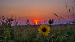 Gorgeous! Instant classic with the sunflower and sun framed by grain.
 -
That outflow boundary from KC to Omaha will provide great low level helicity. It should be a late show, as the atmo takes all afternoon to recover, but it'll go. Also note the southern most cell may not be the cell of interest today. Boundary intersection is northwest. It will be tough to know the right cell until after things start. Subtle setups favor the lucky. LOL at the morning story out of Leawood. Yeah, nobody there goes to shelter for severe warnings. Maybe for tornado warning, but even then too many people go outside for a look.
