

Terpeast
-
Posts
5,360 -
Joined
-
Last visited
Content Type
Profiles
Blogs
Forums
American Weather
Media Demo
Store
Gallery
Posts posted by Terpeast
-
-
1 minute ago, brooklynwx99 said:
SE ridges pop ahead of developing storm systems, and we have also had a blizzard with a trough in the SW US. I mean, this was the pattern a week before the largest snowstorm JFK ever got. I'm sure people would be trashing the Pacific pattern here too given the GoAK low and the ridge axis too far east over the Plains

Same page. I had a debate with bluewave on this a couple weeks ago. Not throwing shade at anyone here, he's obviously a very smart guy who does his research better than most people on here. I just think that there's some confirmation bias going on given familiar "nina-like" patterns common with the last several winters, even if the conditions today are pretty different. I don’t think anyone is immune to this, for sure not myself.
-
 6
6
-
 1
1
-
-
Down to 28 for the low. 32 now
-
23 minutes ago, bluewave said:
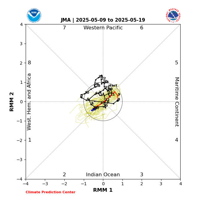
Yet we have some very strong forcing in the MJO 2 to 4 regions along with the Nino itself near the Dateline. It’s why the RMM charts aren’t of much use right now. This is like the atmosphere playing a chord instead of individual Nino or Niña notes. So plenty of competing influences to go around with dueling +30 C warm pools in the WPAC and around the Dateline.


That’s consistent with MJO 3-4 in the RMM forecast. You say RMM isn’t much use, but I see it in good agreement with the VP forecast. Also worth noting that the max -VP anomaly is further north into the bay of bengal rather than within 5s-5n of the equator. I don’t think the 30c pool in the wpac will have as much influence as nino 4, which will start to dominate. We see that in the RMM chart because it kills the MJO wave before it goes into the 4-6 areas. That’s a nino pattern.
-
5
-
1
-
-
7 minutes ago, 40/70 Benchmark said:
You are a low key @snowman19clone.
Will be interesting to see what the next MEI value is. Maybe we’ll finally put the “background nina” concerns to rest.
-
1
-
-
We shouldn’t even be looking at op solutions past day 6. If you must, look at the run to run trends going back 4-5 runs. Then you’ll see why.
-
11
-
1
-
-
Also 25.9 for the low
-
Nice work, we’re on the same page. My outlook is pretty similar.
-
1
-
1
-
-
2 minutes ago, Weather Will said:
Any met comment on DT's thoughts on the -NAO in early Dec? ( that is not really a -NAO?)
I skimmed through. I think he’s splitting hairs. Would have to read it again with fresh eyes though
-
2
-
-
SON should come in at 1.7 next week.
If 3 and 3.4 stay up, OND should come in at 1.9 and that’ll likely be the trimonthly peak.
-
1
-
-
The east based or dual forcing scenario isn’t a convincing one to me, yet.
We still have a huge pool of >30c ssts east of the dateline. Cherry picking model runs aside, I think the mean forcing throughout the winter will be on/near the pool with the warmest ssts (and where the largest sst anomalies are).
-
1
-
-
My neck hurts… from the Webb whiplash
-
 12
12
-
-
Happy thanksgiving ladies and gents!
-
6
-
-
9 minutes ago, GaWx said:
Todays Euro Weeklies SPV strength update was to be a big test because of yesterday’s huge move weaker. The result is that todays not only upheld yesterday’s update, it went further throughout Dec! As of just three runs ago, the Weeklies had a strong SPV for Dec as a whole. Now it has just about the exact opposite! The EPS mean drops below climo on Dec 4th. This compares to 12/25 just three runs ago! And not that a major SSW is required for a weak SPV to result in a -AO/-NAO to become dominant, but today’s update based on the individual members implies a 20% chance of a major SSW just through the first week of January, which is about the highest yet for any run. Keep in mind that the vast majority of major SSWs occur mid Jan or later and that well under 20% of winters through Jan 7th have had a major SSW:
Today’s Euro run: weak SPV dominates Dec:
Euro from just 3 days ago: string SPV dominates Dec:
Yeah, and I think today's model runs are responding to this change.
-
2
-
-
Ensembles still show an active STJ, even if its not directly over our house. Op runs will flip flop in the med-long range, one will show dry another will show wet. That’s all we can take from now
-
11
-
1
-
-
My bar is 3 trimonthlies above 2.0 for a super.
Even if we got to that point, I don’t think the atmospheric response will reflect a super. More like high end moderate to strong.
-
76-77 was cold, but it was also dry
-
4
-
-
The recent WWB plus this:
Only bolsters my confidence that the nino will overpower the -PDO, and we’ll see it mostly uncoupled even if it stays negative.-
1
-
-
2.36” final total
-
That line pushed me over 2"
2.14" with some leftovers to come
-
4 hours ago, brooklynwx99 said:
i mean, we've only been in two legitimate El Ninos in the last decade, so it would be rare given the low frequency. I don't think it's a coincidence that we've already gotten a 8-1-2 pass given that this event is strong
And don't forget the big MJO 8-1-2 event back in the spring that kicked off the first WWB.
I think some are holding onto a certain bias that ignores recent 8-1-2 incursions.
-
4
-
-
Torrential now
-
1
-
-
6 minutes ago, Ji said:
65-66 was my #1 analog too. Did 57-58 make your list ?Not quite, but maybe it should have. PDO was positive that winter, but came after a triple nina -PDO just like this year. QBO was positive though. Solar max, too (we’re close to it now).
-
2
-
-
32 minutes ago, Maestrobjwa said:
@psuhoffman @Terpeast (and whoever else wants to weigh in) Been reading about the PDO this evening...when you made your outlooks, what were your thoughts about about it still being so negative yet with a nino that's strong but not super? Another poster aptly named it a potential "battle royale"...I'm wondering if a weird in between solution is on the table as well...
I think the nino will eventually win this battle royale.
although Ji correctly pointed out 72-73 as an analog, it was east based. This nino is not. Besides 72-73 was near normal temp wise. Just bad luck we missed a blizzard to the south of us.
The better analog in my opinion is 65-66. Also 2009-10 is not off the table either, though I’d want to see what the next MEI comes in… and what the MJO does into mid-late dec.
-
2
-
-
1.2”

December Mid/Long Range Discussion
in Mid Atlantic
Posted
Remember last year we were seeing tons of snow on the controls, only for that to disappear towards D0.
We may not see any snow on the controls this year, but we’ll see if something sneaks up on us inside D3-4