

Terpeast
-
Posts
5,367 -
Joined
-
Last visited
Content Type
Profiles
Blogs
Forums
American Weather
Media Demo
Store
Gallery
Posts posted by Terpeast
-
-
Just now, NorthArlington101 said:

I’d take it
-
35 minutes ago, GaWx said:
The latest EPS extended (bc) MJO forecast is quite encouraging if you want the best chance for BN cold to dominate the E US, especially mid-Atlantic south, late month into Jan from an MJO perspective because it shows weak MJO:

Keeping this EPS weak MJO forecast in mind, look at the amplitude of the MJO when there were E US cold events during DJF: almost entirely weak
Phase 7 by 15th (give or take). Still no can-kick
-
 4
4
-
-
1 hour ago, mitchnick said:
But per the link below, a large portion of 30C area west of the dateline has cooled to almost normal based on 1991-2000 sea surface temps. So how much effect is it going to really have? I dunno, but it doesn't strike me as enough to overwhelm everything.
The dateline east (ENSO 4) has cooled to just 28.54C per Oisst.
Yeah, the recent convection must have cooled those waters. I think the maritime content had 30c but those were shallow. In nino 4 east of the dateline though, the warm waters run much deeper and have more energy to feed convection in mjo 7-8-1.
I predicted in my outlook that all mjo phases would be wide open especially as the IOD faded. Well, the IOD faded a bit a month early, so its good that mjo is going through 4-6 outside of prime climo. It was to be expected though, rather than be seen as bad news. We just have to wait the mjo out and the pieces will be set where we want them to be.
-
2
-
-
25 minutes ago, jayyy said:
Correct. It used to be that you could confidently bet that the GFS was too far SE with the boundary and the resulting storms that rode along it. You could account for a 100+ mile shift NW from what the GFS showed beyond day 4, especially when the EC CMC and NAM aligned on a further NW solution, and take it to the bank. Inside the day 3-4 window you knew that the GFS was going to pull that sucker NW.
No two ways about it. Recent Gfs upgrades have been legit. A lot less long range fantasy snow, and a much more realistic progression at h5. I’d rather it that way. Getting your hopes up because the GFS showed a blizzard while other guidance had slop / rain rarely worked out in the weenies favor.
The euro seems to have lost some its shine over the past several years. It tends to be too quick bringing cold air into the CWA, phasing features, etc.
The pattern looks so close to being ripe around Christmas on today’s runs. But as PSU said, that may be a tad early for a biggie to hit. With that being said… we could still sneak in snow with some luck and good timing. Tend to believe it’d be more of a 2-4/3-6” type event early on the in pattern change progression
.Yeah, I was so sick of getting hopes up with the gfs last year. I’m glad they fixed the damned thing
-
1
-
-
Was the GFS updated after last winter? It hasn’t shown much digital snow like it did last year (very wrongly so ofc)
-
West of rt 15 may see something, but east of that, I’m not as confident.
(I’m 5 miles east of 15 as the crow flies)
-
1
-
-
Cloudy, 36. No precip, but sure has a winter vibe. Nice surprise for the NE part of this sub! Anyone with more than a trace?
Maybe we can call it the first “cumulative” inch and get on with it! (Or is that my inner weenie talking?)
-
 2
2
-
-
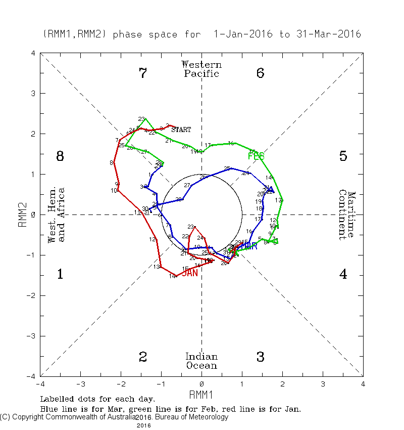
3 minutes ago, GaWx said:
Not only Dec, but the entire DJF of 2015-6 was dominated by much stronger MJO than is being suggested this time at least from late Dec into Jan. Stronger MJO generally translates to a warmer E US. Many of the coldest spells during El Niño have occurred during weak MJO, especially left side. I posted/reposted 15 occurrences with MJO/temps at NYC/ATL in an earlier post to back up my idea. From this point forward, there were only ~10 days of near or within COD MJO during 2015-6, with most of that Jan 18-25. The sole big snow of 2015-6 was on Jan 23rd, which was smack dab in the middle of that weak MJO when the MJO was inside the COD phase 2 (red line):
In stark contrast to the stronger MJO of 2015-6, the following 2 week progs have a weak phase 8 MJO on Dec 20th with extended model progs suggesting it will remain weak and slowly traverse 8/1/2 going into Jan:1) GEFS: very slow move in weak MJO 8 at end
2) EPS: slow move in weak MJO 8 at end
One point to add, we’re progged to get into phase 7 around Dec 12-15. That hasn’t changed, so I’m not seeing a can-kick there.
Also to reiterate, some of our biggest EC snows started as a wave in the N Pac while the MJO was in phase 7.
-
8
-
-
40 minutes ago, NEPASnow said:
Major Stratoshperic warming taking place, let's see where it takes us.
.thumb.png.3e68fba41c3c542abaaf33defaf949ec.png)
The plot thickens. It may take a while to work its way down though.
-
1
-
-
Grats to those who saw flakes today. Sunny here lol
-
Deck and car was wet, pavement kinda dry. I assume it was rain because I never went below 36 for the night
-
3 hours ago, psuhoffman said:
Terpeast was transparent with his methodology and the limitations. It’s very valid to point out that the entire storm track could be altered. But it’s impossible to assess that through data analysis. We would need a very sophisticated simulation. However I would argue it’s highly unlikely such changes would end up being a net positive simply because the net impact of warming overall would be to adjust everything north on the whole and average snow decreases as you go south of us.
Thanks, psu. I was kinda surprised at the reaction. Maybe they forgot about that analysis I did a few months ago. And yes we’d need modeling resources if we really wanted to dynamically simulate what a past storm would like today, but we don’t have those resources.
Anyway, back to our regularly scheduled tracking…
-
5
-
-
Dry here. 37
-
46 minutes ago, psuhoffman said:
I suspected that Feb 66 storm would be a loss. Wasn’t the Feb 87 also a complete loss? If so it’s slightly disturbing that 2 of the biggest snows in 2 of the best analogs would be rain now! That does make me nervous given my ambitious forecast. But I also figured maybe other storms end up compensating. Of course it has to be cold enough at some point for that to work lol. But this highlights my biggest fear. That historically our snowiest patterns often weren’t really that cold. Cold smoke 8”+ snowstorms are not very common. As we continue to warm we’re flirting with disaster because we don’t have much margin left for what is our best snowfall producing long wave patterns to still be viable in DC.
ETA: yes some storms under the right conditions will get enhanced but over time they would become fewer and further between until it’s almost irrelevant that once every very long while we get some crazy blizzard. That’s like NC used to be. Every so often they get some big snow but who cares they would go years between any significant snow. No self respecting snow weenie would live there.Feb 1987 is also a loss based on my analysis, yes
-
 2
2
-
2
-
-
2 hours ago, psuhoffman said:
I agree and I went big in my snowfall forecast but to play devils advocate the 1966 could be a risky repeat. A significant portion of the January snow was from a triple phased storm. All of the Feb snow was from a very marginal storm where temps were near freezing. Would that even work anymore. Take away that huge January storm and if the Feb storm is a mixed mess v snow and that season wasn’t that good anymore.
@psuhoffmanis right about 65-66.
The marginal Feb event that dropped 9” at IAD would be a total loss today (all rain).
But the January blizzard would be even more juiced. Like 50% more qpf and snowfall totals.
If that were to repeat, such a historic blizzard would become even more historic, rivaling or even beating the Jan 1996/Feb 2010/Jan 2016 class of blizzards.
Do we take this chance?
I would.
-
7
-
-
2 minutes ago, GaWx said:
I absolutely have been saving a bunch of the Euro Weeklies SPV progs. I was the one repeatedly mentioning the can kicking that went on between the Nov 1 and 19th runs. Remember? After that, they suddenly got much more bullish about a weak SPV.
In recent days, I’ve noticed not as weak of an SPV in early to mid Dec as in runs from a few days ago and in late Nov. We have to make sure this won’t turn out to be a mirage just like with all model progs for anything.Today’s isn’t as weak as the three prior days.
Any trend in timing?
-
47, cloudy.
-
5 minutes ago, WxUSAF said:
Don’t know about that, but odds of KU storms are certainly higher than normal this winter, particularly mid Jan-mid Feb.
Yep. Not now. But around then.
We can see the STJ start loading its ammo and taking aim at the SE US on recent runs, especially 12z gfs.
-
4
-
-
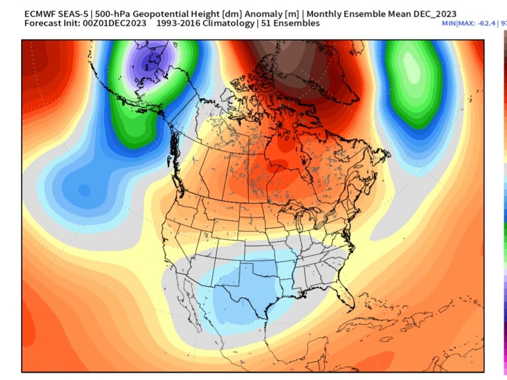
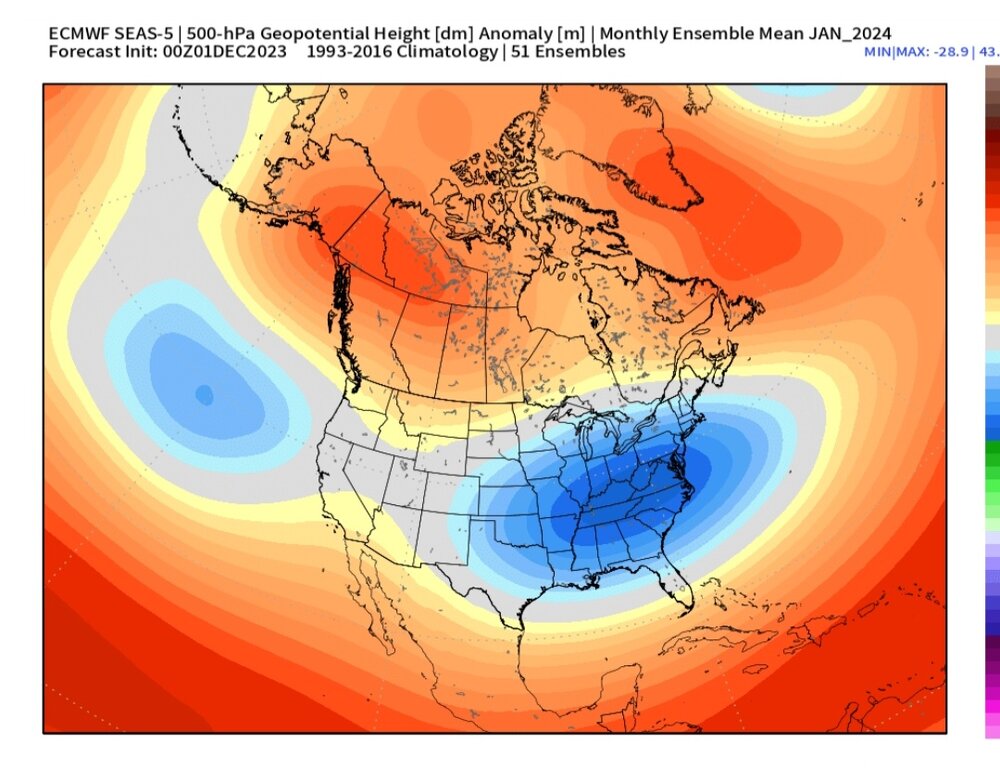
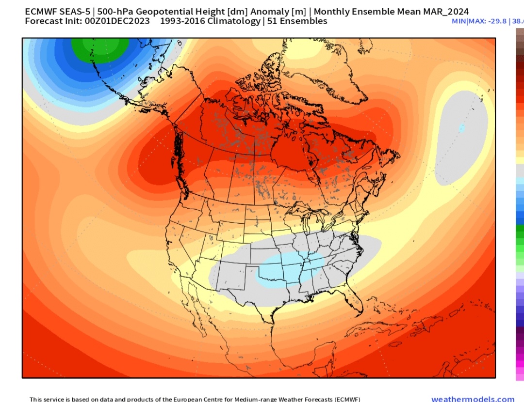
2 minutes ago, stadiumwave said:
Euro Seasonal Update
DEC
JAN
FEB
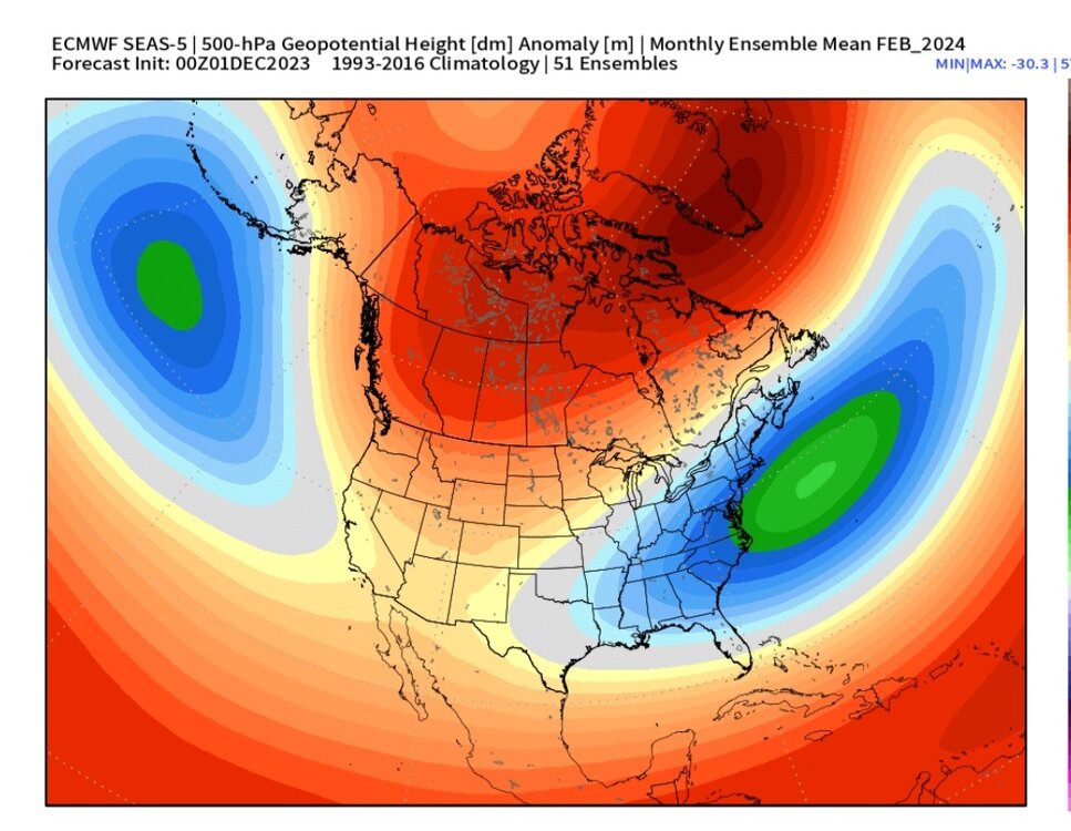
MAR
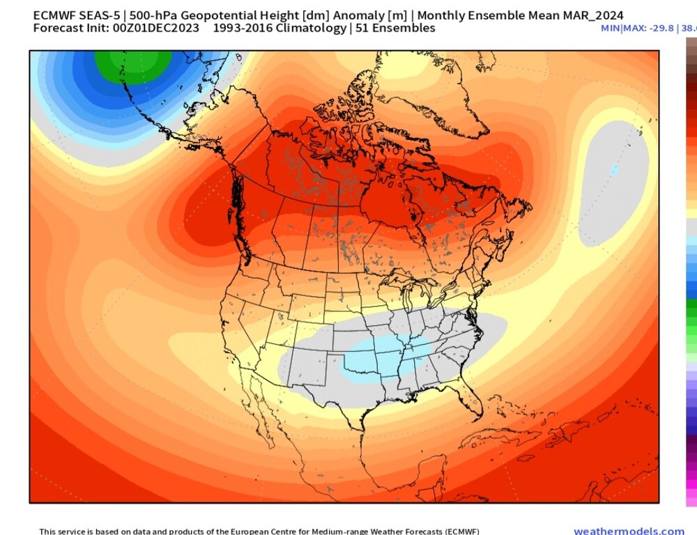
Looks even better
-
3
-
-
4 minutes ago, so_whats_happening said:
To get back on topic a bit here is the upcoming look at the WWB there is certainly something there.

Judging from the gradients near the dateline, forcing should strengthen around the dateline and then drift a bit east after Dec 17 or so
-
2
-
-
1 hour ago, psuhoffman said:
So let me get this straight...according to him the traditional warm phases 3-6 are warm, but in an el nino the cold phases 8-1-2 are also warm? SO WTF is cold?
Consider the source. Smart guy, but heavily biased towards persistence in favor of CC. He will be proven wrong for a time eventually. He has a tendency to cherry pick the warmest analogs for any given pattern. First it was 2015-16, then it was 1997-98, and on it goes.
-
1
-
-
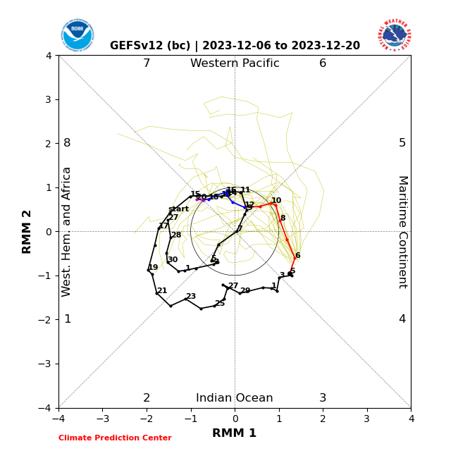
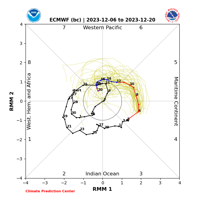
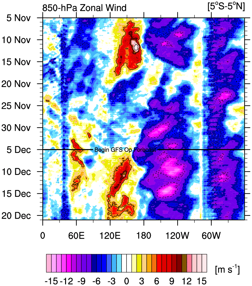
8-1-2 a warm signal over the EC in Dec-Jan?
That’s news to me. I double checked the temp charts for each phase, and I’m seeing the opposite.
As long as the MEI stays under 1.2, we should stay close to normal +/- 2 deg
-
27 minutes ago, frd said:
Interesting post by @bluewave
One of the main issues with the longer range model forecasts for the MJO beyond 10 days is that the ensembles weaken the convective signal too much. This is also true with the RMM charts. So some of the posts on twitter stating that the MJO will quickly weaken or progress to 8-1-2 are basing that on an an inherent model bias. So it’s no surprise that the convection in the warm phases this week is verifying more intense in the warm phases than the runs back in late November were indicating. This is one of the reasons ensemble forecasts have been correcting warmer for December than they were indicating later in November. So even if the MJO can eventually get over into phase 8-1-2, that is also a warmer signal from December into January with an El Niño.
New run

Old run

I like what these VP forecasts are showing. Nice trend. I don’t agree that 8-1-2 necessarily means warm in the east if the MEI stays under 1.2 (iow the nino doesn’t go super)
-
1
-
-
Still doesn’t look like a palm-trees-can-grow-in-NYC torch to me
-
6
-
12
-

.png.275ed121b937c2478424d7946ce640fc.png)


El Nino 2023-2024
in Weather Forecasting and Discussion
Posted
Better now than Jan/Feb