

Terpeast
-
Posts
5,360 -
Joined
-
Last visited
Content Type
Profiles
Blogs
Forums
American Weather
Media Demo
Store
Gallery
Posts posted by Terpeast
-
-
Busted on precip, but its so refreshing out. Went for a 30 min run at 68 degrees.
-
 2
2
-
-
FYI:
pns25-41_RRFS_legacy_model_cessation.pdf
To save you a click, the topic is about "Soliciting Comments on Proposed Discontinuation of the North American Mesoscale (NAM) model and other Regional Modeling Systems to be Replaced by the Rapid Refresh Forecast System (RRFS) through July 26, 2025."
-
 2
2
-
-
Reached 98.1 just now, but not sure it’ll go up that much more because clouds are starting to pop up, meaning convective temps have been hit like midatlanticwx says.
-
96 already at 11:30 am. 78 dewpoint
-
2 minutes ago, MN Transplant said:
I’m going to top out at 97.9.
Put this ridge over us in mid-late July and we’d be in 2011 territory.
Yeah its only June. Plenty of time for another ridge to build over the top.
-
Hit 99.7 max, close but no cigar. Down to 97.9. Maybe an hour left for another push to 100, but I don't think it's going to happen
-
97/74, HI 109 - 1 degree ahead of yesterday. 50/50 I reach 100
-
91 at 9:30 am, running 2.5 degrees ahead of yesterday. Legit shot at 100 today, probably the better chance than tomorrow.
-
Morning low of 75, which is really warm for mby
-
2 minutes ago, MillvilleWx said:
Yup! The additional higher dew points has made this feel worse than at any point last year. I mentioned a week or so ago about the higher ground moisture content may curb the air temps a bit, but the humidity will be a bigger problem in the grand scheme. Sweltry is the word for this kind of heat.
Yep I was thinking the same after all that rain in May thru early June. This humidity is no joke.
-
1
-
-
3 minutes ago, MillvilleWx said:
Hi of 99F
Low of 78F
Heat Index hit 115 during my mid-afternoon walk after my post night shift sleep. It's been years since I felt anything like this. Have to go back to when I was in Central Texas middle of July in 2022. Yuck
Last year was hot, but iirc dews were lower, upper 60s low 70s. This time it felt like a whole new level.
-
 1
1
-
-
29 minutes ago, MN Transplant said:
Highs:
98 at DCA (99 was the record, way back in 2024)
97 at BWI (1 short of 2024’s record)
96 at IAD (2 short of 2024’s record)
Remember kids, always ignore the Euro surface temps in summer.
Feels like the 96 at IAD doesn’t do justice on how hot it was here. Dews were really high. 75-79 in most obs west of the airport.
-
So far 99 for the high, peak HI of 119!
Currently 98.8/76.3 (114.6 HI)
-
1
-
-
97.5 for the high, max HI 115
-
94/105, heat advisory verified
-
1
-
-
92/75 at noon, HI 104
-
90 at noon
-
1 hour ago, Eskimo Joe said:
NWS point and click for 21136 has 89° for my afternoon high. It's not yet 10 am and I'm already at 81°.
Mine is 91 for the high, and I’m at 88 at 11 am
-
Lost power for an hour. Rain rate topped 3”/hr at one point. Winds were gnarly. Probably verified at low-end severe (60mph). Only 0.6” total, short but intense.
-
1
-
-
29 minutes ago, George BM said:
Oh okay...
This isn’t the first time. These neutral teases aren’t going to cut it. We need it to break through to sustained +1 at least
-
3
-
2
-
-
14 hours ago, Bob Chill said:
No, not like that. Imho- record breakers are more likely than less likely. Something will line up just right and put down insane totals before long. Juice is real and prolific qpf makers in general are on the increase.
Bread butter frequency is what is worrisome. The punch of the northern jet seems to be retreating on avg and south of the M/D never had a lot of room to spare even in the better times of decades past. Lack of clippers is a good example of what I'm talking about among other things. 2014-15 was 10 years ago already. Seems nearly impossible to get a run of clippers and overrunners since. The 4 decades before that had plenty.
I second this.
-
2
-
-
With all the rain we’ve been getting, the humidity in this heat wave is gonna be stifling.
Yesterday the high on my pws was 90, but the HI was 104!
-
1
-
-
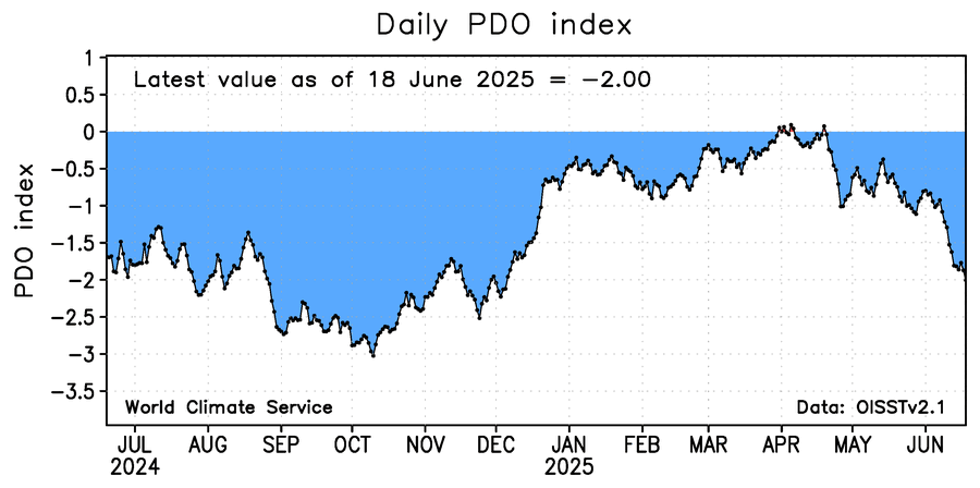
15 hours ago, Stormchaserchuck1 said:
Still an impressive -PDO.. and my N. Atlantic SST Winter NAO prediction method is now running positive

Interesting that both pac and atl have similar spatial patterns
-
Another 1” on top of 0.9” for a total of 1.9” this weekend. 2.5” MTD
-
3
-
Winter 2025-26
in Mid Atlantic
Posted
Yep, that’s pretty much what he is saying. And I’m thinking the same.