

Terpeast
-
Posts
5,371 -
Joined
-
Last visited
Content Type
Profiles
Blogs
Forums
American Weather
Media Demo
Store
Gallery
Posts posted by Terpeast
-
-
94/105, heat advisory verified
-
 1
1
-
-
92/75 at noon, HI 104
-
90 at noon
-
1 hour ago, Eskimo Joe said:
NWS point and click for 21136 has 89° for my afternoon high. It's not yet 10 am and I'm already at 81°.
Mine is 91 for the high, and I’m at 88 at 11 am
-
Lost power for an hour. Rain rate topped 3”/hr at one point. Winds were gnarly. Probably verified at low-end severe (60mph). Only 0.6” total, short but intense.
-
1
-
-
29 minutes ago, George BM said:
Oh okay...
This isn’t the first time. These neutral teases aren’t going to cut it. We need it to break through to sustained +1 at least
-
3
-
 2
2
-
-
14 hours ago, Bob Chill said:
No, not like that. Imho- record breakers are more likely than less likely. Something will line up just right and put down insane totals before long. Juice is real and prolific qpf makers in general are on the increase.
Bread butter frequency is what is worrisome. The punch of the northern jet seems to be retreating on avg and south of the M/D never had a lot of room to spare even in the better times of decades past. Lack of clippers is a good example of what I'm talking about among other things. 2014-15 was 10 years ago already. Seems nearly impossible to get a run of clippers and overrunners since. The 4 decades before that had plenty.
I second this.
-
3
-
1
-
-
With all the rain we’ve been getting, the humidity in this heat wave is gonna be stifling.
Yesterday the high on my pws was 90, but the HI was 104!
-
1
-
-
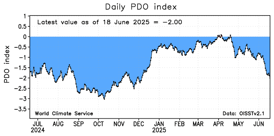
15 hours ago, Stormchaserchuck1 said:
Still an impressive -PDO.. and my N. Atlantic SST Winter NAO prediction method is now running positive

Interesting that both pac and atl have similar spatial patterns
-
Another 1” on top of 0.9” for a total of 1.9” this weekend. 2.5” MTD
-
3
-
-
Last night saved me from a total bust. 0.9”
-
Hoping I get another chance for significant rainfall today with the expanded flood watch
-
9 hours ago, WxUSAF said:
0.05”. Congrats NoVA on the 5-10”
Only 0.05” imby
-
1 hour ago, LibertyBell said:
Are they too cold because of trying to dampen down their overproduction of TCs? Why adjust global models for TCs anyway? That's not what global models are for! Use tropical models for TCs and use global models for temperate cyclones.
This wasn't about tropical cyclones...
-
No reason to think next winter will be much different than the last winter or the last several. Enso may not be a big player this year, so I’d lean more on the pdo and polar domain. Qbo going negative, but solar may have already maxed. No idea yet.
-
4 hours ago, bluewave said:
These models just can’t see the Southeast Ridge and strength of the Pacific Jet past 120 hrs. So the snowfall beyond 120 hrs has been shifting further north over time.
February was a prime example of this model bias. The 30”+ totals which were forecast around NYC wound up much further north. Places like Toronto got the record 30” snowfall with only 7.1” in NYC
One of the things we’re working on with AI models is using hindcast climatology where the 10-15+ day cold bias is much less or no longer there. This might help solve the problem of models being too cold in their medium range forecasts. It’ll also be interesting to see if that also solves the bias of weaker upper level wind flow predictions vs reality.
-
1
-
-
1 hour ago, bluewave said:
It’s all about the way model biases have been evolving over the years. We went many years near the I-95 corridor when the long range models weren’t snowy enough beyond a few days. Which is the complete opposite of the model error pattern since 2018-2019 with the record breaking Pacific Jet.
The January 1978 KU snowstorm was originally forecast to be a rainstorm the day before and we got a surprise 15” snowstorm on Long Island. Then in February 1983 the original forecast a few days out was for the heaviest snows to stay down near Philly. But instead the heaviest snows shifted north into NYC Metro as the models got under 60 hours.
The January 1987 KU event was forecast to be snow quickly changing to rain but instead we got a surprise 6-12”. The December 1988 surprise Norlun wasn't even forecast at all and we got a narrow 6-12” band.
The January 1996 blizzard was originally forecast to get suppressed to the south of NYC from 120 hrs out. But came north in the models only 24 hrs out. The late January 2000 snowstorm was forecast to be OTS and delivered record snows in the Carolinas and over 6” around NYC.
The record January 2016 snowstorm was only forecast to be 6-12” the day before around NYC and turned out to be 20-30”.
So model errors in good snowfall seasons tended to be underdone beyond 24 to 48 hours out.
What the models have been doing since 18-19 is showing heavy snows beyond 72 to 120 hrs only to correct further north with the heavy snowfall axis. So the error has been for the storm tracks to verify warmer and further north than originally forecast.
This model error pattern worked for us with colder storm tracks to our Southeast which dominated before 18-19. Since the long range forecasts could still afford to shift north changing suppression to a KU. These days the storm track is already too far north so any shift north under 60 hrs gives us to more rain.
So cutters, huggers, and suppressed Southern Stream storm tracks have lead to the record low snowfall from Philly to Boston last 7 years. The big snowstorm has always been beyond 120 hrs out. So this has become the dominant model forecast storm track bias.
The one good thing about repeating model biases is that I use them in real time to correct the long range model forecast biases leading to better forecasts than the models.
If you’re talking about the biggest KU storms, I tend to agree. But there have been instances in recent winters where sub-KU storms have actually trended south in the last 24-72 hours.
In the 2023-24 winter, my subforum (at least the central part) got 4-6” flush hits twice in the same week that trended to us the last minute after being modeled to go through PA/NY.
This past winter, we’ve had a few happen the same way. Including one in late Feb that missed us and hit SE VA with a foot of snow, leaving us high and dry.
So I guess it can cut both ways.
-
2
-
-
0.18” here this morning. May got me 8.77” for the month!
-
2
-
-
Got 1.6” this past event.
-
4
-
-
0.3” so far
-
Dry here. Just completely fringed. Glad this isn’t a snowstorm lol!
-
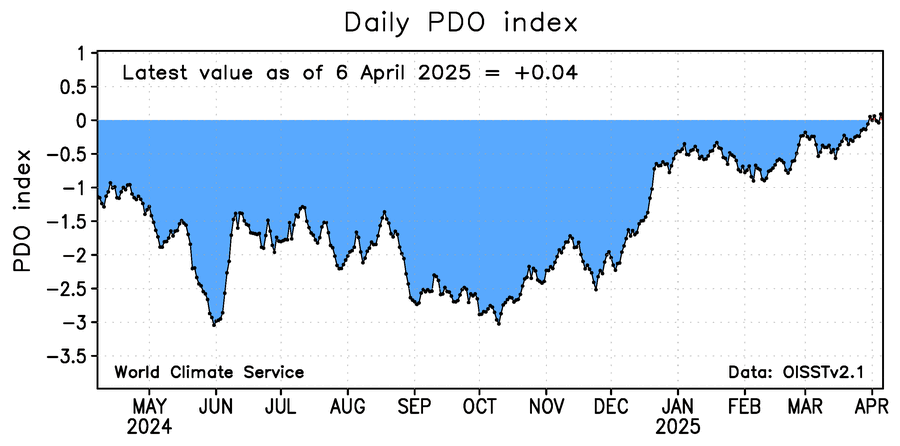
Don’t look now, but WCS daily PDO is no longer negative for the first time in many years
-
3
-
 1
1
-
-
Haven’t been following the forecasts lately. I got 0.76” last night. Was that within forecast range?
-
1
-
-
C+/B-
ended up with 17”, just a few inches short of climo but more days with snowcover during a cold january. Got lucky with the feb storm reaching warning criteria with a sharp cutoff just to the NW of me. Biggest storm of the season 7.5”
June Discobs 2025
in Mid Atlantic
Posted
97.5 for the high, max HI 115