

Terpeast
-
Posts
5,367 -
Joined
-
Last visited
Content Type
Profiles
Blogs
Forums
American Weather
Media Demo
Store
Gallery
Posts posted by Terpeast
-
-
1 minute ago, Scarlet Pimpernel said:
ICON is not only way far south, it's as if there's not much of a storm there at all...very dry looking overall. Even the max zone is pretty small compared to earlier.
Narrator: “Plot twist, there is no storm.”
-
 4
4
-
-
1 minute ago, SnowenOutThere said:
All I’m asking for is a dead cat bounce to a 2-4 snow to get me out of school
a 50 mile shift is not much at this range and while that is certainly possible even in this case, it’s doubtful given the strong trends the opposite way.
-
 1
1
-
-

NAM caved. It may still show 3-6” here but with the trend that amount will dwindle in the next several runs.
-
 1
1
-
1
-
-
Well. That was… exhausting. Need to rest and turn off all screens and devices. I’m out.
-
2
-
 1
1
-
 1
1
-
-
6 minutes ago, MN Transplant said:
The NAM gives us the route that we want, it is just unfortunate that it is the model that we least trust.
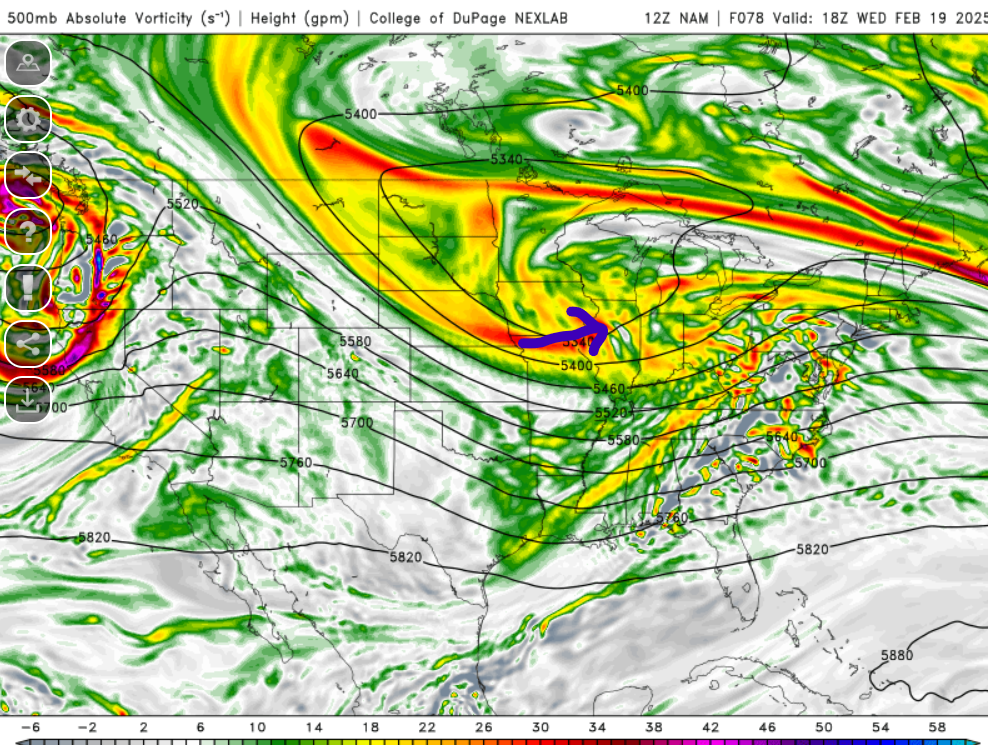
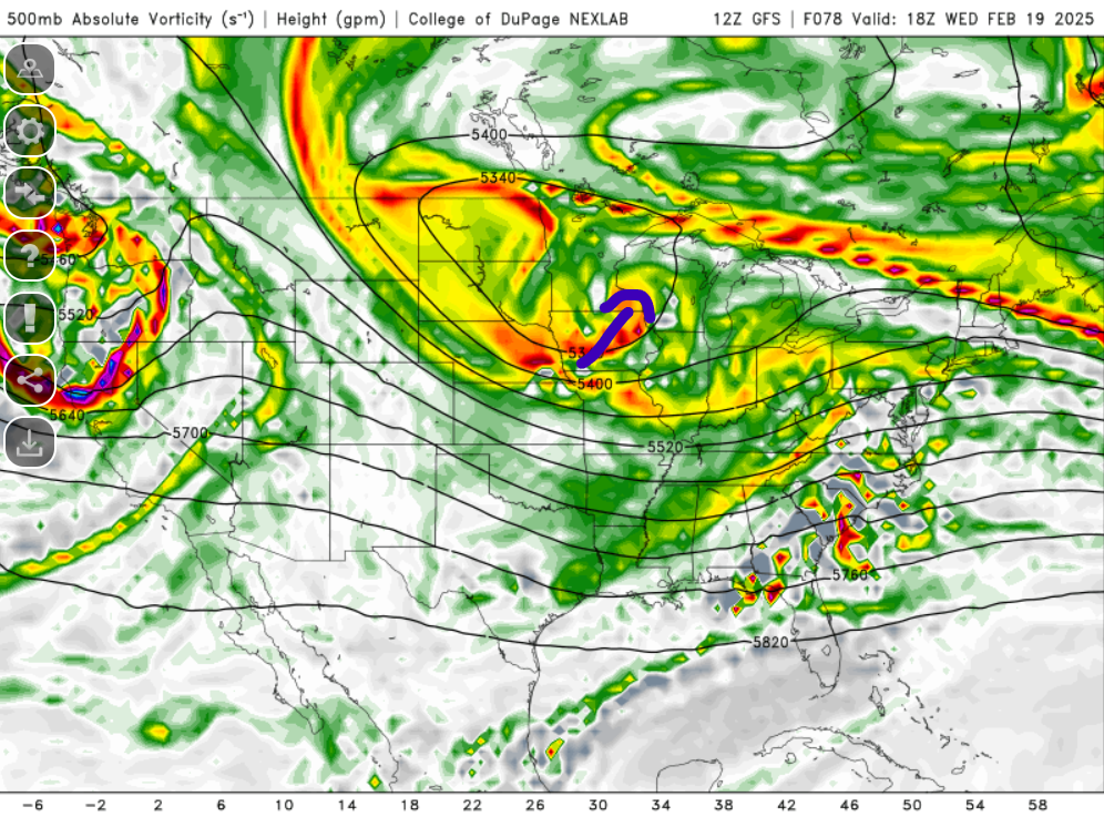
The top image is the NAM. The vort that swings through is helping to close off the 500 low near Chicago. The bottom is the GFS, where it is closing off the low over Minneapolis. We need the vort to help us bridge, not cut off.
Thanks, now we know what to watch for in the next runs
-
2 minutes ago, AlexD1990 said:
To say that's disappointing is a understatement. Seems like it's not just the progression of Wednesday's storm that fell apart on guidance.
Tbh I never really bought into the favorable pattern going all the way to mid march. I had it going to march 1 maybe 2, before it warmed up. Now the warm up is coming a week earlier, but it may be a brief warmup. It may get cold again after that, but I don’t know how favorable that pattern would be for snow.
-
1
-
-
Just now, AlexD1990 said:
So the "favorable period" that was supposed to last to 3/15 is dead?
Probably
-
1
-
-
4 minutes ago, psuhoffman said:
Now wouldn’t that be the ultimate kick in the nuts. If tomorrow all the models come back north and show us getting 20” and we throw a party. Then they keep going and it ends up a central PA jack and we get snow to rain!
Do you really believe that this may happen? Two differences between now and march 2001- modeling is better, and the block is so strong.
I mean, a 30-50 mile shift NW, sure. But 200-300 miles in this situation? I think that is less likely
-
2
-
1
-
-
We want it to trend more stream interaction. We may not see results at the sfc immediately
-
3
-
-
2 minutes ago, psuhoffman said:
Ok ya it’s the NAM. I wish it was annything else. But it’s doing what I said the mid and upper level pattern should look like at the surface. Focusing more on the wave among the arctic front which pulls everything north further east.
Images from my post last night about what changes I expected to see. Now if we can get everything else to come around maybe. Can’t believe I’m on a team with JB and the NAM. Shoot me now.


Since NAM is a mesoscale model, maybe it’s seeing something that globals aren’t seeing wrt gulf moisture and latent heating putting the slp track north. LWX alluded to this in the afternoon AFD.
-
7
-
-
If anything 18z nam is a bit faster
-
63, heights tick lower across the board but vort/energy is stronger and norther. Angle of attack still more NE
-
3
-
-
18z nam 54, h5 vort angle of attack a bit more NE
-
1
-
-
3 minutes ago, Terpeast said:
On both, go back 24 hr. You’ll see that the SS sw doesn’t dig as much as before
Otoh, NAM doesn’t dig that much either but is way more north. So there’s that…
-
2 minutes ago, mikem81 said:
If someone can look at h5 from yesterdays 12z euro and compare to todays and somehow explain why the surface is so Much worse today is really appreciate it.
On both, go back 24 hr. You’ll see that the SS sw doesn’t dig as much as before
-
1 minute ago, psuhoffman said:
It does but it’s unusual for a closed low that far northwest of that amplitude to produce a wave that escapes south of us. There is a feedback to this. With a closed upper level low they far NW the surface should amplify enough to feedback with some height rises in front. There is a reason there are no examples of a big SE VA snowstorm with this look. None. Zero zip.
on the other hand reliable upper level data only goes back so far. Maybe it’s a once a century type thing and we’re about to see the first instance of it.
One would think models would start correcting more NW for that reason, but they’ve been going the other way instead. Maybe it’s still too soon for a NW correction.
-
1
-
-
Looking ahead… there will be a warm up the last week of feb into first few days of march, but it may be brief as mjo is slow to get through 1-2-3 and epo ridge showing signs of rebuilding
-
3
-
-
1 minute ago, Ji said:
the NAM every once in a while is known to pick up things--so lets hope its seeing something that can be salvaged
Mike Thomas at fox is giving this until tomorrow to turn around
-
3
-
-
Just now, mitchnick said:
In case you were wondering how different the Nam looked to the Euro at 84hrs.

NAM seems to have better divergence across PA/NJ, guess thats why its track is north
-
1 minute ago, DDweatherman said:
Why waste our time sharing what looks better when the outcome keeps ending up worse. Such bullshit how it ends up looking at the frames leading in
Honestly thought it would turn out better based on h5 leading in, but the sfc fell apart at the last minute. So im feeling what psu is feeling. Something about this feels off.
-
2
-
 1
1
-
-
Not the reversal we wanted to see. Sorry guys
-
93, still light snow. Definitely slid off SE moreso than previous runs
-
Its more SE
-
3
-
-
84, its trying to tuen the corner
-
2
-


February Medium/Long Range Thread
in Mid Atlantic
Posted
I know we’re upset about the modeling fail, and I am too… but objectively, this has been a decent winter south of i-70 especially after going in with -enso/-pdo/+qbo and a high chance of a wall-to-wall torch.
I wouldn’t change my grade on this winter even if it ended today. C+/B- imby, B+/A- for the southeast zones who jacked twice in the biggest storms. My grade is based on how much cold we had, how much snow fell, how many “snow days” we had, and how long snow cover lasted.
Model performance gets a totally separate grade, and I’m not as generous on that end.