

Terpeast
-
Posts
5,371 -
Joined
-
Last visited
Content Type
Profiles
Blogs
Forums
American Weather
Media Demo
Store
Gallery
Posts posted by Terpeast
-
-
With the way the radar is looking, I think there will be lots of haves and have nots with snow. I’m sure radar will fill in as the sfc low forms and moves up the coast, but it won’t be an area wide accumulation event most likely.
-
11 minutes ago, psuhoffman said:
I assume you mean the WRF-FV3? I noticed it went the other way v the NAM. Guess we will know soon when the global come in if the NAM was just a hiccup. NAMs are jumpy as F and cause so many early panics because they come out first each suite, that’s kinda unfortunate. If they came out last we would ignore all their tangents.
No, I just meant the regular GFS. Was looking 12-18 hours ahead
-
Short range op GFS insistent on a more neg tilt while Euro has trended more neg the past 4 runs.
3K NAM trended more neutral tilt in recent run, but its a meso model so not sure how much we should weight it on synoptic trends (probably none)
-
 5
5
-
-
-
9 minutes ago, EastCoast NPZ said:
At the very least end this drought.
Yup. This is a loaded STJ trained on us with plenty of ammo
-
2
-
-
Models doubling down, getting interesting. Tomorrow we’ll be in nowcast mode. Feels good to be tracking something before mid-dec
-
13
-
 1
1
-
-
2 minutes ago, nj2va said:
Meh, too much time spent looking at uber LR models IMO. Look at Monday - sort of popped up out of nowhere when we were led to believe December is being written off. Yeah, it’s not a 6-8” storm, but early on in climo, I’m excited we have something to track. YMMV.
It would be a big win to get an inch on the board in the middle of a lousy pattern early on!
-
2
-
-
2 minutes ago, nj2va said:
Yeah, 100% agree. I don’t see any can kicking honestly.
The mjo entry into 7 got can kicked though, maybe that’s why the weeklies are showing what they’re showing now. But it’s still early and no need to get concerned unless we pass xmas and the models keep pushing the pattern change back
-
2 minutes ago, psuhoffman said:
I’m legit curious what NWS and NCEP prefer when making short range forecasts. But honestly given the inconsistency of all high res (especially the NAMs) I tend to still weight the GFS/Euro for giving me the general Synoptics then use common sense and the high res to get an idea what the meso scale features will look like. But I apply those meso features to the GFS/Euros larger synoptic representation. I don’t trust the high res models at all for picking up trends wrt the larger features.
Thats probably what the NWS offices do as well.
-
3
-
1
-
-
1 minute ago, MN Transplant said:
Yeah, that's probably closer to reality given the sfc temps. Not trying to be a downer, but I'm always reserved on anafronts
-
3
-
-
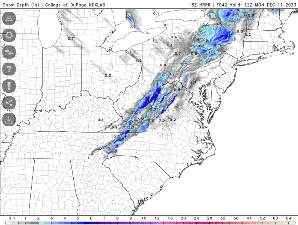
8 minutes ago, Stormchaserchuck1 said:
snow depth maps always verify the best
Looks like 1-2" imby with 4-6+ along the blue ridge
-
8 minutes ago, cbmclean said:
I'm honestly scared to even look at the ensembles today. Someone braver than me: has the can-kicking started, or has it held steady?
They look the same to me. No real can kick. But they don't look all that great either.
-
1
-
-
HRRR soundings suggest temps at 33-35 F west of I-95 towards route 15
-
2
-
-
Looks like the 6z nam 3k had a bit of a hiccup. 12z looks a lot like 0z, just less overdone. Many people west of 95 might see some flakes if up early enough, higher elevations (including Mt PSU) may see an inch or two, more west of the blue ridge
-
6
-
-
5 minutes ago, CAPE said:
I was referring to his 97-98 reference, implying the entire winter will be a disaster.
Yeah, I don’t think this is another 97-98 because the pac forcing is way different. It’s just the NA is too warm now, need to give it time to cool down
-
3
-
-
1 hour ago, CAPE said:
We are going to need some help in the NA. All signs still point in that direction in the coming weeks.
Track is an app runner. No cold high to hold it off the coast
-
I’m still not buying. BL temps too warm. I’m looking at TT and it appears most models took a step back with cold air progression
-
2
-
-
7 hours ago, stadiumwave said:
I've read more whining on social media than I can bare. I've seen nothing change for the worse. The thought has always been a typical warmer El Nino DEC that toward the end of the month begins improving & into JAN has good winter potential.
My analog package which consisted of 2 super El Ninos, 3 strong El Ninos, & 2 moderate had the typical Dec warmth.
A nice JAN with colder conditions in SE & with a strong Aleutian low.
Aleutian low weakens & retrograde in FEB & that month has the strongest high latitude blocking.

Winter ends late FEB & transitions to a warmer March.
Headed onto January the 0z long-range GFS looks great.


Recent mjo got can kicked a few days to a week, though. But December was always going to be warm anyway. Still expecting Jan-Feb to be colder (near normal give or take a couple degrees)
-
1
-
-
19 minutes ago, WEATHER53 said:
That front in 1995 kicked off epic 95-96
I remember, my cousin and I took a jebwalk out in that one. Will never forget it.
And then it didn’t snow at all through the entire december, and we were complaining “it never snows here anymore”. Then…
-
1
-
 1
1
-
-
31 minutes ago, jayyy said:
Exactly. Why are some folks pretending that places like buffalo didn’t see a 6 foot snowfall last December? Or that Caribou Maine didn’t just have a winter storm warning like 3 days ago? It still snows in early December in colder / northern areas. Patterns mean everything, as you said. Every year isn’t going to be the same. As it turns out, it can rain in Canada during winter months. Crazy concept, I know.
Let’s be real honest for a moment. We have been pretty spoiled for the better part of the past 20-30 years (minus the past dreadful 7 and a few other random downer years) We got pretty damn lucky over that 20-30 year span where we saw at least 1 big storm most years. Some years (01-02, 10-11, 14-15) were epic with multiple big storms, while other years were average to just above average.
This isn’t the first time the eastern half of North America has been in a prolonged snow drought, and it certainly won’t be the last. YES, this is the least snowy 7 yr period in our history and we can debate all day as to why that’s happening, but it doesn’t mean we are fucked forever.
Folks are obsessing way too much about things that aren’t relevant. Not everything is correlated. A December 16th nor’easter dumping rain on Maine doesn’t mean we’re screwed. Yes, it’s becoming harder to snow in marginal setups, especially early on in the season, but that doesn’t mean we’ll never see another blockbuster winter again. Maybe it’s harder to snow in early December, but juicier storms with more qpf in January - February could easily make up for that.
Let’s take this winter a week at a time and not get too far ahead of ourselves. We are in a MUCH better position going into this winter than we have been in several years. Let’s save the worrying for when it’s actually warranted.Well said man
-
3
-
-
I think the NAM is overdone, but it sure feels good to be tracking something while it’s only dec 8. And we’re not even in a good pattern right now.
Totally different vibe than last year
-
15
-
-
Latest LWX AFD acknowledged snow might fall at lower elevations, but unlikely to accumulate with temps at 35-36. Let’s see if we trend colder though.
-
9
-
-
2 minutes ago, Ralph Wiggum said:
Exactly. I'm pretty certain the PAC jet extension has some positive net results for us here. Even in that graphic you can see the epo ridge building and a split flow off the W Coast.
I was going to say that.
So yep, bring it on!
-
2
-
-
40 minutes ago, NorthArlington101 said:
3k is in. What was exciting to me was seeing better offshore development from the LP... I'm not dumb enough to think there is any chance this goes crazy, but I have to imagine a redeveloping low in our primo spot cannot hurt? I'd assume that helps to keep precip around after the cold pushes in. Also doesn't hurt that it flips to snow faster on the 3k

Not saying this is a credible threat, but in order for this to pan out, yes we’d need that secondary LP to develop while the h5 trough axis lags behind fropa
-
5
-
4
-


12/10-11 Disco / Obs - Rain/Snow/Wind Event
in Mid Atlantic
Posted
Is that HRRR 3k different from the HRRR on TT? Different outputs