tavwtby
-
Posts
2,814 -
Joined
-
Last visited
Content Type
Profiles
Blogs
Forums
American Weather
Media Demo
Store
Gallery
Everything posted by tavwtby
-
I'm curious what the streak is here for sub 50°, I don't think it's been over 45° here since mid November, and that is just a handful of days above 40°, quite impressive cold winter, at least my driveway isn't a skating rink like last year tho. edit: I just checked and appears 11/5 was 50.1°, last time it was 50+ here anyway.
-
 down to -5.7° here, but that wind is making it brutal... otherwise it's not that bad, to me anyway, my wife hates it, I've worked in shit like this and honestly prefer it over 95° with 70+ dews, but that's just me.
 -
high today was 22.7° at midnight, and 17.1° at 12, it's now 0, with 23 sustained and gusts 45+, only got an inch new but seems like more with the wind blowing it over everything old, nice little refresher hopefully more by the end of next weekend.
-
Friday February 6 FROPA / WINDEX small event
tavwtby replied to HoarfrostHubb's topic in New England
oof! wind is atrocious, got about an inch but the cold and winds are the business! deep winter out there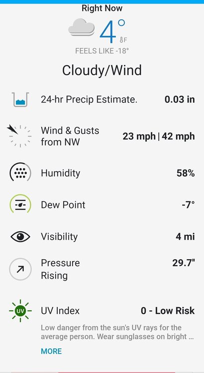
-
Friday February 6 FROPA / WINDEX small event
tavwtby replied to HoarfrostHubb's topic in New England
my poor ladies haven't come out of the coop since I fed em this morning, they want no part of this wind and cold -
Friday February 6 FROPA / WINDEX small event
tavwtby replied to HoarfrostHubb's topic in New England
just under an inch here, but man wind already howling, had a gust over 40 already, but is that a meso low of the coast of RI moving north? cyclonic behavior of the returns moving almost like a supercell with rotation -
Friday February 6 FROPA / WINDEX small event
tavwtby replied to HoarfrostHubb's topic in New England
tough call with this ivt setups, models could be off by 50-75mi and then it's a whole new ballgame, more of a nowcast type thing, like Jan 2011, iirc was modeled east of where it really sat and dumped... anyway, we coat here, anything would be nice to refresh things a bit. -
Friday February 6 FROPA / WINDEX small event
tavwtby replied to HoarfrostHubb's topic in New England
yeah this was a nice one when I was in Waterbury, lost my wedding ring in the snow that night and we'd just gotten married a few months before, but wound up with a good 10" I think, one of many that month. roofs collapsing everywhere -
right now the GFS is alone with anything significant that ain't a cut or whiff, but all have something in that time frame that can pop, we'll see and maybe a convergence comes about for something good, at least we track...
-
11-14° around me but down in the valley it's close to 0, crazy how they can radiate in auch a short distance.
-
I was mistaken earlier about the run of days below freezing, on 1/22 I hit 42... however avg for January is 30.1°, and ytd is 29.9°, all days, including the warm in Jan, never got above 44°, and 1/25 almost got out of the single digits while dumping snow, pretty impressive temp run here... I honestly don't know what the average monthly temperature is here, i never finished that, but I'd bet it's maybe top 10 coldest January here anyway... looks to continue for another week at least, hopefully ending with a big dog and then I'm about ready for warm, this weather is killing my vehicles.
-
Winsted Holabird Ave, if that helps...like a lot of "towns" Winsted is in Winchester, but it's like Waterbury and Torrington, areas that are low next to the river and areas over 1k', I'm just under that.
-
nah, 23.6° on the 21st here, I'm curious what the record is in this area for below freezing
-
30.9° for a high today that makes 18 straight days...
-
per my station it says the 15th was 35, and before that I think the 11th, of course I'm looking on a phone so I need to go back day by day for Jan still, haven't had time. but it's been a grip since it's been over 32, that's all I know and my wife can't stand the winter so it's all I hear...
-
29.5° today felt like 60 honestly, I don't think I've been above freezing here in a couple weeks, that mid Jan thaw was the last time I think...the cold I can handle it is the wind that kills me and drafty house ftl.
-
Possible coastal storm centered on Feb 1 2026.
tavwtby replied to Typhoon Tip's topic in New England
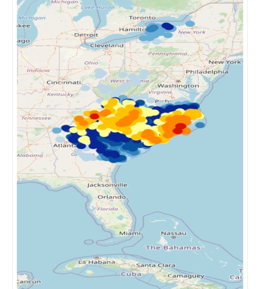
nice swath of 12-18+ down there and freeze warnings just about to the tip of FL, not sure I've seen that before, let alone snow and freezing temps in the deep south back to back years.
-
damn that's crazy
-
i figured last night was going to plummet, instead it pretty much flat lined after about 9 or so
-
lowest so far was 1/28 here at -7.6°, currently is 4.0 here, at least it's not windy, yesterday was brutal cold with the wind.
-
this works, did it in 2011 with 37" on the roof, worked great. sounds weird but works
-
that sucks, I used to lock in a price early, and had delivery once a month even if to top off, worst was digging out a path to the street in late jan 2011, it was over 6' by the time I got to the street, you can see layers of the storms avg depth was about 37/40"... took me all day, but I had oil, he wouldn't deliver otherwise.
-
Possible coastal storm centered on Feb 1 2026.
tavwtby replied to Typhoon Tip's topic in New England
yup I always know good runs happen by the amount of new posts -
Possible coastal storm centered on Feb 1 2026.
tavwtby replied to Typhoon Tip's topic in New England
not a bad look 72 hours or so out, but I hope this isn't like the 2015 storm where there was 24+ amounts eor, and I was stuck with heavy sand and maybe 8-10" of it, I don't remember what I got here in that one honestly, but still impressive for poor snow growth, also coldest day so far at -7.6° -
Possible coastal storm centered on Feb 1 2026.
tavwtby replied to Typhoon Tip's topic in New England
the chimney ridge can maybe be a little more west no? and a little truncated, seems very steep, don't we want that W and a little less sharp so the S/W has a bit less digging and tugs W more