tavwtby
-
Posts
2,814 -
Joined
-
Last visited
Content Type
Profiles
Blogs
Forums
American Weather
Media Demo
Store
Gallery
Everything posted by tavwtby
-

Rise of the Machines: January 18-19 Winter Storm Obs Thread
tavwtby replied to WxWatcher007's topic in New England
they cut back even more from the one you posted, now 2"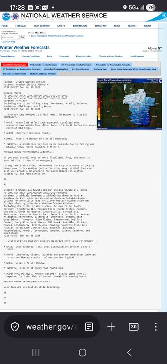
-
Rise of the Machines: January 18-19 Winter Storm Obs Thread
tavwtby replied to WxWatcher007's topic in New England
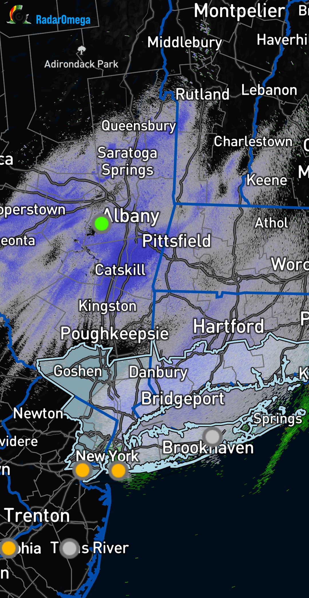
this is ALY weather map, to go along with their messages and alerts, I was countering Mikes claims that they cut back and they should on this one I just posted as well
-
Rise of the Machines: January 18-19 Winter Storm Obs Thread
tavwtby replied to WxWatcher007's topic in New England
yeah I posted the ALY snow map -
Rise of the Machines: January 18-19 Winter Storm Obs Thread
tavwtby replied to WxWatcher007's topic in New England
they came down a half inch from the last update, but 5.2 for Torrington is a stretch, was 5.7 not long ago.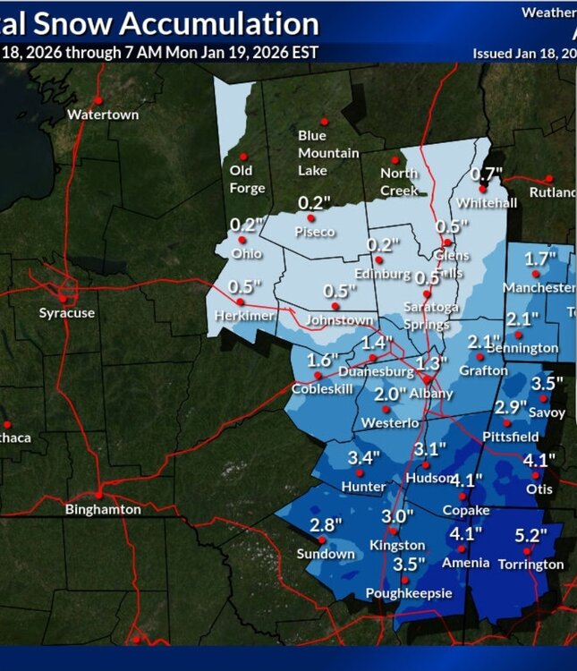
-
Rise of the Machines: January 18-19 Winter Storm Obs Thread
tavwtby replied to WxWatcher007's topic in New England
radar SW is blossoming nicely, need to keep that track, currently nothing happening, but I expect that to change within the next hour or two -
Rise of the Machines: January 18-19 Winter Storm Obs Thread
tavwtby replied to WxWatcher007's topic in New England
yeah ALY still showing almost 6 storm total to 7am tomorrow, highly doubt that, but yesterday surprised me and them, as they had 3, and we were double that when they updated, so... we'll see -
Rise of the Machines: January 18-19 Winter Storm Obs Thread
tavwtby replied to WxWatcher007's topic in New England
if that meat in NJ and SEPA stays together, and moves as modeled, all sne can get in on at least a couple inches -
Rise of the Machines: January 18-19 Winter Storm Obs Thread
tavwtby replied to WxWatcher007's topic in New England
also, seeing a nice H7 fronto right across CT about following 84, have to see if that pans out with the deep DGZ, and after the sun goes down. might be someone who pops 8" if it breaks right with both features -
Rise of the Machines: January 18-19 Winter Storm Obs Thread
tavwtby replied to WxWatcher007's topic in New England
somehow picked up an inch new from this morning to now with on and off snizzle, sometimes moderate sn, but was sucking exhaust from the band that stayed just NW of my area, every time it looked to crash SE it dried out, expect around 5 o'clock for second round, still not expecting more than a couple inches, nice norlun look on some short range for tomorrow morning, after around 2-3ish... some have it pretty beefy too -
Rise of the Machines: January 18-19 Winter Storm Obs Thread
tavwtby replied to WxWatcher007's topic in New England
i suspect around 4/5 we should start to see the meat of round 2, I'm not expecting more than a couple inches, you should be good for about 4 down there I think -
Rise of the Machines: January 18-19 Winter Storm Obs Thread
tavwtby replied to WxWatcher007's topic in New England
almost half inch new, light snow and dim sun, hoping later is better once the sun goes down and it gets closer, think it may shunt east for my area anyway for anything meaningful -
Rise of the Machines: January 18-19 Winter Storm Obs Thread
tavwtby replied to WxWatcher007's topic in New England
about 1/4" of light snow, but watching this batch that is slowly shifting SE towards NW CT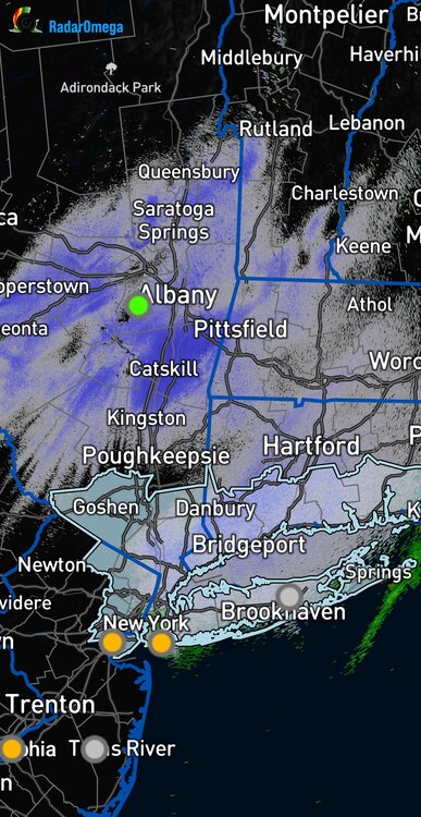
-
First Legit Storm Potential of the Season Upon Us
tavwtby replied to 40/70 Benchmark's topic in New England
yeah was it the bosa roughing the passer play? which also had a DPI that got them to the 8? -
Another Coating of Snow Saturday - "It's all we Got"
tavwtby replied to Sey-Mour Snow's topic in New England
just got done cleaning, trying to keep my 76 yo dad in the house but that dude has work ethic like the Amish...any 6.0" even, compaction ftl tho as there's under 5.5" now OTG, if we can get lucky with some NW meso band tomorrow, will be a nice weekend for winter, winter back on, gotta check but I believe I'm a few inches from 30", and Jan isn't over, so we have a shot of climo finally in almost a decade. -
Another Coating of Snow Saturday - "It's all we Got"
tavwtby replied to Sey-Mour Snow's topic in New England
terrible! have not seen a plow in hours, but they were throwing sparks the other day when it was wet... I'm at 6" even btw and going to start cleaning -
Another Coating of Snow Saturday - "It's all we Got"
tavwtby replied to Sey-Mour Snow's topic in New England
ALY still under the total from 7pm Fri to 10pm Sunday with 3.4" in Torrington... we're going to double that just today the way it's been going, just when I think it's winding down, it starts ripping again, nice winter snow weekend to pick up spirits, here at least, sorry for those missing out but you should get yours tomorrow -
Another Coating of Snow Saturday - "It's all we Got"
tavwtby replied to Sey-Mour Snow's topic in New England
still coming down nicely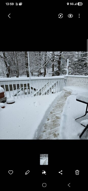
-
Another Coating of Snow Saturday - "It's all we Got"
tavwtby replied to Sey-Mour Snow's topic in New England
yup, I'm at about 6 here myself, friend sent a report from new Boston up the road at 7" -
Another Coating of Snow Saturday - "It's all we Got"
tavwtby replied to Sey-Mour Snow's topic in New England
looks like back edge approach, maybe another half hour or so under this little band, but damn, almost the best of the winter so far, but awesome that it was day time -
Another Coating of Snow Saturday - "It's all we Got"
tavwtby replied to Sey-Mour Snow's topic in New England
must be choking flakes in that -
Another Coating of Snow Saturday - "It's all we Got"
tavwtby replied to Sey-Mour Snow's topic in New England
yeah noticed that too, round 1 is being compacted by the paste that's been ripping for a while now, so OTG total is a little different than what has fallen total. -
Another Coating of Snow Saturday - "It's all we Got"
tavwtby replied to Sey-Mour Snow's topic in New England
I'm pushing 4.5 storm total here, gotta be areas in the Berks over 6 by now, it's paste too -
Another Coating of Snow Saturday - "It's all we Got"
tavwtby replied to Sey-Mour Snow's topic in New England
I don't think yesterday, but last week this was showing as a legit storm and then got pushed to the 18th/19th, so they had a clue at some point -
Another Coating of Snow Saturday - "It's all we Got"
tavwtby replied to Sey-Mour Snow's topic in New England
pounding and a nice band about to run through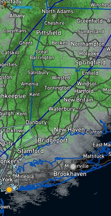
-
Another Coating of Snow Saturday - "It's all we Got"
tavwtby replied to Sey-Mour Snow's topic in New England
closing in on 4 here, nice over performing event, if I can squeeze a couple tomorrow, I'll take that as a win...