tavwtby
-
Posts
2,814 -
Joined
-
Last visited
Content Type
Profiles
Blogs
Forums
American Weather
Media Demo
Store
Gallery
Everything posted by tavwtby
-
haven't been in the panic room yet, but I gotta say this is getting old hat really fast, nice looking sig, and as we close in, there's one mechanic or another that skunks us (at least SNE) out of at the least a plowable event... I was never a snowpack person, I'd be happy if we get a good storm, and it warms and melts, but we can't seem to manage that, and with me possibly being gone for maybe a month from mid January on, I may not see anything until late Feb... hoping for the best, preparing for nothing... I will say the lack of artic cold has been good as far as utility bills go, so plus there...
-
been dying to use the new ariens since we got it, hopefully we can reign in next weekend, but I'm loosing faith, and after that I'll be staring at palm trees for weeks again
-
yeah last year was one of lower 5 of all the records I have going back before 1900, 37.5 i believe, not in front of my computer but I think that was it
-
had an interesting ride into work, basically at BDL... went from a little white on grass at home, to pretty sketchy slick roads top of 219 in barkhamsted, then by rt20 in Granby back to rain, top of that hill probably had an inch on all surfaces, maybe a bit more on grass etc, but definitely accumulation on roads, that was about an hour ago. here at bdl it's mixed mangled and rain
-
actually whitening up the ground here I'm shocked, decent dendrites falling
-
rained for the majority of this little event, no surprise, but paws are now flying as it's exiting right...
-
me too, especially when it was showing nearly the same before Christmas ha!
-
back to pike north thinking, thought this had a chance for a while but again, not enough amps, or too warm, etc .
-
goose egg
-
yeah I said the same, their temps hardly match what I record anyway so grain of salt
-
WU going hard at the totals for next week
-
ha, ALY snow maps show expected 1.2", but it's higher than the high end expected, of course the low end is nada...
-
a balmy 39/37 here ..and there was a time euro was king, kind of a dice roll these days, just look for trends on either, ensembles and short range once inside 36 hr I guess, or now cast it...and try to find analog for the setup and match
-
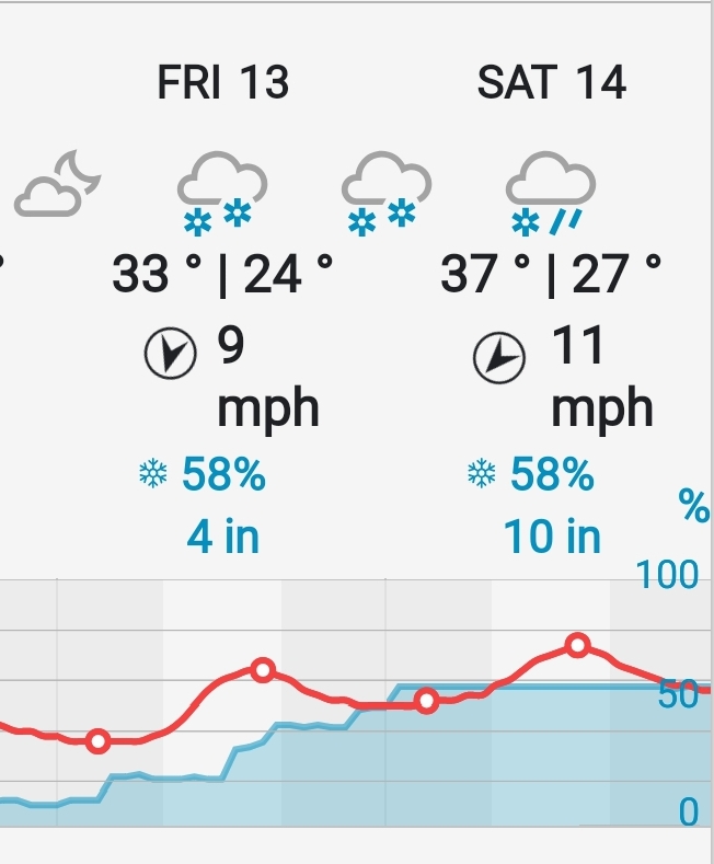
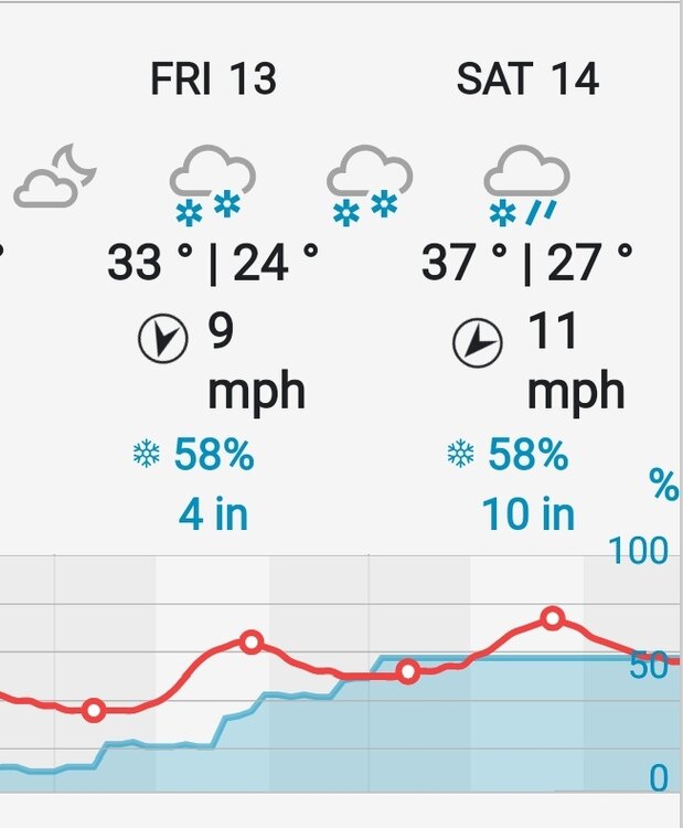
might be a bit too late for mby, but orh and adjacent areas could do nicely with this one...may whiten the ground here, ALY has about 1-2" expected, we'll see, temps and dews are iffy, but liking what I see next weekend. of course I won't be here most likely...
-
nam is a good advisory event for almost everyone away from the coast, trending better, a good coating of snow would lighten spirits in here
-
I'm telling you, I'm slated to head south on the 13th for Soflo for a couple weeks, it'll snow like crazy, seems like the theme for me this winter...in all seriousness, I've liked the look for Friday for a while, but feel it fading for anyone south of at least the pike and that's even sus... but next weekend looks very interesting with multiple waves to track and one that may be a region wide plowable event...of course I'll be looking at palm trees again. Maybe upon my return we'll get a nice stretch before I leave to head back again.
-
that would lighten spirits a lot it seems, just to at least be white and not crap brown, staying positive the snow gods deliver, especially for nne, ski country could use it
-
I've been watching this first one for a while, appear/disappear, and we still have a shot at a marginal event, but I think antecedent airmass will be the enemy until some CAD pushes in, there is a strong high to the north, too bad the low wasn't a bit stronger... still like the period mid month, and possibly a small event on between, but at least there are s/w's to track as we approach what's historically our best climo for big snows.
-
as fate would have it for me this season, I'm leaving for an extended period for work in Florida on the 14th, right around the time things look to be lining up nicely, I've missed nearly every flake this season, and still have yet to use the new blower...ugh, at least my dad has taken the skywarn class, so he's capable of accurate measurements if anything falls on the snow table...
-
Dec. was a D here, 7.5 ytd, 6.25 on Dec, well below normal for this locale
-
wouldn't give up on next week, the 6th timeframe has looked interesting for a bit now but the phantom off run disappearing sig is weird...then the 9th, and looks like a decent potential around the 13th, with some phase possible? interesting to say the least, we have things to track, and hope we ain't warm wet, cold dry again...
-
So some of you may do this ( if you're not actually mets for a vocation), gathering archive data from your local station and doing plots, avg, temps, snow etc... I just got done plotting the seasonal snowfall for my area from 1897 (farthest I could get), to present and noticed an interesting anomaly, all three top seasons occurred exactly 40 years apart, 35-36, 55-56, and 95-96, with 55-56 being the top at177+"... so I assume 2035-36 will be an interesting winter... that said I'm working now on temps both for calendar year and seasonal, as well as total precip, nice little hobby in spare time.
-
most of our seasonal snowfall is nickel and dime events, most of which are SWFE, maybe one or two region wide events, and rarely get a KU.. hopefully we can string together a few nickel and dimes and splash in a biggie and just might make climo...
-
that's a nice look... does the GFS still have a SE bias or was that fixed with the upgrade?
-
I'm currently going through a ton of archival data from my area anyway, and from what I've seen so far, early to mid March is much more of a snow producer than mid to late December, there are exception, but on average, March is a snowier month, at least for mby and generally SNE...