WNash
-
Posts
1,184 -
Joined
-
Last visited
Content Type
Profiles
Blogs
Forums
American Weather
Media Demo
Store
Gallery
Everything posted by WNash
-
That band is so narrow that we have bright sunshine and moderate snow at the same time.
-
I’ve seen the dual band structure but it’s usually much more transient. This is amazing.
-
Think about everything that needed to come together for this storm. There’s only a short window when the lake is freezing up for a major storm. And to get delta Ts like this, you need to have anomalously frigid air. Add to that the particular heading that goes over the two areas of open ice, and this becomes a very rare event.
-
There you go. It’s like we have two lakes.
-
I wonder if the consistent dual structure of the storm is being affected by the configuration of the open ice.
-
The north band is back. Unfortunately the transition zone is back too.
-
Had to make a quick drive to get lock de-icer for a padlocked gate. A surprising number of drunk UB students were on the streets near south campus, totally underdressed for the conditions - wind chills far below zero, occasional heavy snow, high winds, and ground blizzards. A lot of these kids are downstaters, and I don’t think they have any idea what they’re facing. Very concerned that tonight may see a tragedy.
-
Even my wife, a southtowns native, is impressed by this storm.
-
Yeah, it’s back up here. Not as heavy as earlier but still 1/2 in per hour stuff
-
Hard to tell, but with the snow since 7, we have to be over 18 inches. And that northern band is coming in pretty heavy now. Haven’t gone out yet to snowblow- I own a wimpy Toro single stage because we haven’t needed anything more heavy duty, and because I have narrow walkways to clear, but I’m regretting that now.
-
Going to bed. Winds are strong enough now that measuring is impossible. I’d say that we have had at least a foot or so since this morning. Dendrites are much smaller but coming down at a higher rate. Looking forward to clearing this out in the morning and admiring the snowpiles!
-
Squall is coming through NE Buffalo. Can’t even see the houses across the street.
-
So far this is the kind of Northtowns crusher I've been hoping for. Fingers crossed that the band has residence in the area through the night.
-
It's going to be unusually cold, so I wouldn't be surprised if we get 20:1 later on. But definitely not that 28:1 stuff that the Kuchura spits out. I don't think I've ever seen that verify.
-
Heavy snow with very limited visibility at UB North.
-
This is potentially the kind of northtowns crusher that we haven’t seen for a long time.
-
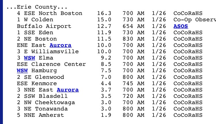
I drove out to Clarence Center and back. There's sublimation and compaction since yesterday - the 6.5" we had in NE Buffalo looks more like 5" this afternoon. But I went on Kensington to Main, then up to UB North, then out to Transit on North French, then down to Main. It was consistent 5” to 9” for basically all of that route. Down Transit, it was also about 8-9” until near Eastern Hills Mall, then it went to maybe 15”. The biggest cutoff was at ECC. On the ECC campus near Werle, I measured 18” - but on the north part of ECC near Main, I measured 8”. So it’s pretty clear the band set up from the airport along and above Werle and out to roughly Main and Transit.
-
Those reports capture it pretty well. Biggest snows were south and east of a line from just north of the galleria to just north of the airport to roughly Maple and Transit to Clarence Center. I have to drive out to Klein and Transit this afternoon so I can try to verify where the cutoff of that band is.
-
It was a good storm for the fraction of the northtowns that it affected, and that part of the northtowns hasn’t been in a long term LES drought. For the most populated parts of the northtowns, it was maybe half a foot over a day and a half, which is barely advisory criteria.
-
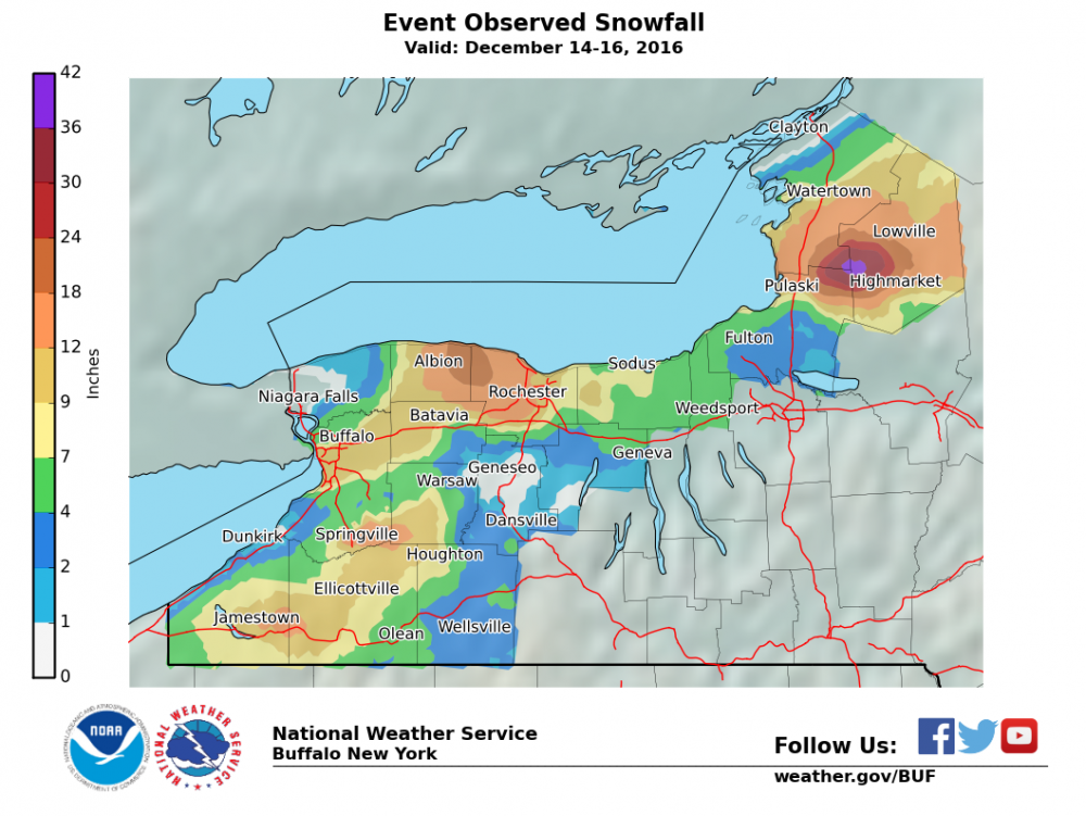
That’s definitely the best one in the last decade or so. I lived in Parkside then, and we had 12”. If I recall, that band moved north from downtown up to the Tonawandas and back, so there were two periods of 2” - 3” per hour snow of about 2-3 hours each. A pretty good storm, but that was over four years ago, and that one event, putting down about a foot, is as good as it has gotten for North Buffalo and the near northtowns in the last decade.
-
I’m not talking about Grand Island, or the Town of Tonawanda. I’m talking about near Northtowns - Kenmore, Amherst, Williamsville, Snyder. These are places that have have gotten LES events every couple of years in the past but now have seen a lake effect drought of 10+ years.
-
A storm that hits the airport and missed the northtowns isn’t even that infrequent. Here’s one from last year that demonstrates that very clearly. 10” at the airport and a dusting in Amherst.
-
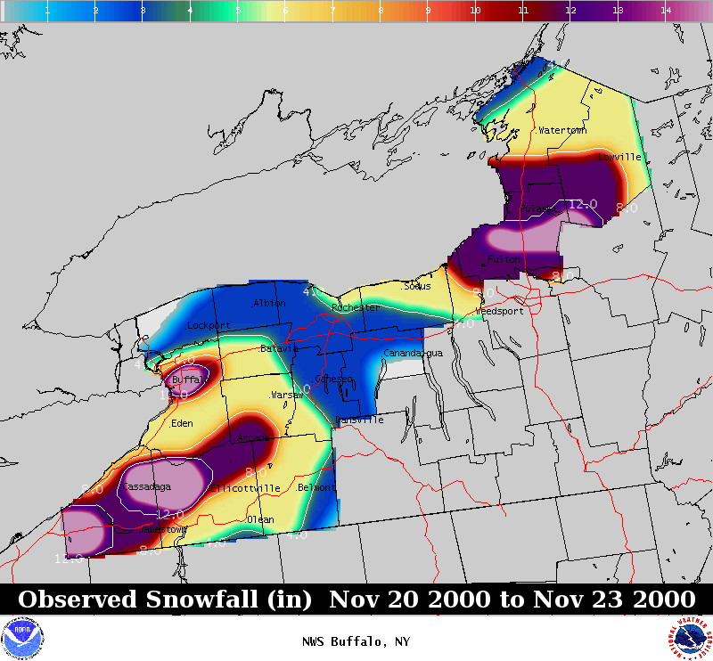
I’m not talking about very rare storms that bury North Tonawanda. The NWS Buffalo lake effect page and the lake effect storm book show storm that hit the near northtowns, including Kenmore, Tonawanda, Williamsville, and Amherst, very hard - not every year, but not as rarely as in recent years. The crippling November 2000 storm is another example, and it’s not hard to find storms that gave a solid hit to the northtowns more frequently than the decade plus drought we are currently in.
-
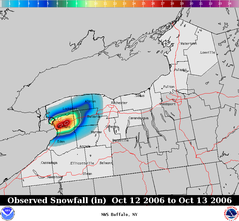
The airport is in Cheektowaga, not really the northtowns. The only part of the northtowns that really got hit was Clarence, which often gets storms that are southtowns oriented. A paradigmatic northtowns storm is the October surprise. While the amounts were extreme, we haven’t even had a lesser storm with a northtowns bullseye since then. That is the real drought.
-
Updated totals from yesterday. This was definitely not a Northtowns storm. Between the overnight snow on Thursday and the transient bands yesterday evening, the NE corner of Buffalo got a little more than six inches. Fingers crossed we get one or two more chances at breaking our LES drought up here before Lake Erie shuts down until next year.