WNash
-
Posts
1,184 -
Joined
-
Last visited
Content Type
Profiles
Blogs
Forums
American Weather
Media Demo
Store
Gallery
Everything posted by WNash
-
Upstate NY Banter and General Discussion..
WNash replied to wolfie09's topic in Upstate New York/Pennsylvania
OK - I have a friend in the 79th. -
Upstate NY Banter and General Discussion..
WNash replied to wolfie09's topic in Upstate New York/Pennsylvania
Possibly, but there are also considerable deflationary pressures right now. -
Upstate NY Banter and General Discussion..
WNash replied to wolfie09's topic in Upstate New York/Pennsylvania
My thoughts are with your coworkers. Sorry if you mentioned this before - what precinct are you? -
Upstate NY Banter and General Discussion..
WNash replied to wolfie09's topic in Upstate New York/Pennsylvania
This is a really big deal - the virus was freely circulating at least six weeks before things were shut down. On the bright side, it implies that there are many more cases that were non-fatal than previously thought, but that would need to be confirmed by a review of additional deaths. What's personally interesting is that this information may tend to confirm the experience of a number of people I know (including me) who had mysterious illnesses in February and later wondered if they had COVID-19. I missed a week of work with an illness in mid-February with cough but no congestion, fatigue, and a feeling of shortness of breath. -
Upstate NY Banter and General Discussion..
WNash replied to wolfie09's topic in Upstate New York/Pennsylvania
If you can avoid the hottest part of the summer, a including the Grand Canyon, Sedona, Zion, Arches, is a great driving vacation. -
Upstate NY Banter and General Discussion..
WNash replied to wolfie09's topic in Upstate New York/Pennsylvania
Lmao, he’s a clown. -
Upstate NY Banter and General Discussion..
WNash replied to wolfie09's topic in Upstate New York/Pennsylvania
I do accept your apology, thanks. We may think people who disagree with us are contemptible, but it’s another think entirely to throw around personal insults in this forum (except for “weenie”). -
Upstate NY Banter and General Discussion..
WNash replied to wolfie09's topic in Upstate New York/Pennsylvania
You must not have looked very hard. This tweet predated that Facebook page by a couple of hours. It includes a link to the Facebook account of the deceased, which has been taken down (you also can tell it actually once existed because his friends tagged him in their condolences and the tags are broken). https://mobile.twitter.com/JoeTall/status/1251990220007813120 It also doesn’t take much effort to find more MAGA chuds who were the echo chamber for their big dumb president’s lies about COVID19 and then died of it. I’d rather not link to their names because it’s actually very sad — I may think a few of my extended family members are a**holes and have the politics to prove it, but I’d still rather them not die after loudly shouting that COVID19 is no worse than the flu. I pray that they have the sense to let learning correct their bad judgement. -
Upstate NY Banter and General Discussion..
WNash replied to wolfie09's topic in Upstate New York/Pennsylvania
An economy that has seen income and wealth shifted to the top by deliberate changes to tax law, public policy, labor rights, etc. You’ve made it clear here that these decisions are fine by you because you claim you grew up incredibly poor and by sheer force of will you are thriving, while everyone not at successful as you is lazy and deserves nothing. But the consequence has been that a huge swath of society will be cut down and suffer, either by deprivation or by this disease, unless we do what we have been doing and use the vast wealth of society to provide sustenance for some people for a while. You disagree with that approach because of your political views, so in essence you’re saying: screw those lazy scumbags, they can go die. -
Upstate NY Banter and General Discussion..
WNash replied to wolfie09's topic in Upstate New York/Pennsylvania
I see, so you want to send other people off to die so some rich people can stay rich. -
Upstate NY Banter and General Discussion..
WNash replied to wolfie09's topic in Upstate New York/Pennsylvania
Do you have evidence of that? Are you saying that none of the Trump cult loudmouths who have been running their mouths and commenting online, repeating what their dear leader said about how COVID-19 just being like the flu or a cold, have gotten sick and died? -
Upstate NY Banter and General Discussion..
WNash replied to wolfie09's topic in Upstate New York/Pennsylvania
KENTUCKY REPORTS HIGHEST CORONAVIRUS INFECTION INCREASE AFTER A WEEK OF PROTESTS TO REOPEN STATE https://www.newsweek.com/kentucky-reports-highest-coronavirus-infection-increase-after-week-protests-reopen-state-1498835 -
Upstate NY Banter and General Discussion..
WNash replied to wolfie09's topic in Upstate New York/Pennsylvania
What percentage of people does it take to gain herd immunity? Are you proposing they all be volunteers? -
Upstate NY Banter and General Discussion..
WNash replied to wolfie09's topic in Upstate New York/Pennsylvania
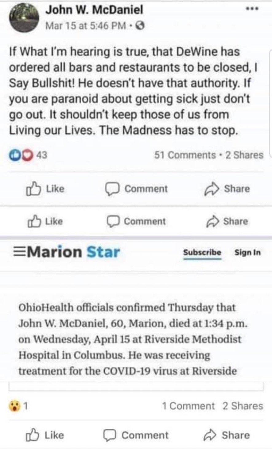
That satire account may have shared it, but they didn’t originate it. More and more people who don’t take this seriously are going to be dying, but that doesn’t matter to the fake “pro-life” Trump supporters. I’m sorry for this guy’s family, but there will be many more like him if the death cult nuts get their way. https://www.snyderfuneralhomes.com/obituary/john-w-mcdaniel/ -
Upstate NY Banter and General Discussion..
WNash replied to wolfie09's topic in Upstate New York/Pennsylvania
What’s in store for people who try to outsmart a deadly virus
-
Upstate NY Banter and General Discussion..
WNash replied to wolfie09's topic in Upstate New York/Pennsylvania
Part of this crew of professional protesters? https://www.washingtonpost.com/technology/2020/04/19/pro-gun-activists-using-facebook-groups-push-anti-quarantine-protests/ What’s the term for fake grassroots protesters who are really doing the bidding of the elites... AstroTurf? -
Upstate NY Banter and General Discussion..
WNash replied to wolfie09's topic in Upstate New York/Pennsylvania
I usually have you on ignore, but I figured you were responding to my comment, so I am briefly unhiding your post. You are conflating the principle of supply and demand, which is *an* input — not the only input— on pricing of objects of commerce with the effect of nominal wage change on real prices. Your claim is a political one, not an economic one. EDIT: I didn’t say anything about scarcity here, but I think the choice to base an economy on conditions of scarcity is a pretty stupid model to use, even if it does allow a relatively small and powerful elite to enrich themselves. -
Upstate NY Banter and General Discussion..
WNash replied to wolfie09's topic in Upstate New York/Pennsylvania
I’ve seen here that some people claim we can’t stabilize wages for the unemployed because of inflation, but a causal relationship between nominal wages and consumer prices is being proven false. We are seeing a significant decline in nominal wages, yet there is no *deflation*, which makes it pretty clear that *inflation* is caused by something other than an increase in nominal wages. I know that won’t make the “higher nominal median wage causes inflation” canard disappear, but at least we can now recognize that when someone brings it up, they’re not basing it on macroeconomics but on their political preferences. -
Upstate NY Banter and General Discussion..
WNash replied to wolfie09's topic in Upstate New York/Pennsylvania
I wonder if this is related to blood type. Some viruses have an affinity to given blood types. Malaria, for instance, affects people with Type A more than other blood types. The COVID-19 causing virus seems to attack the capacity of red cells to carry O2, so it may well hit people one blood types harder than others. -
Upstate NY Banter and General Discussion..
WNash replied to wolfie09's topic in Upstate New York/Pennsylvania
Just-in-time inventory doesn't work for outlier events, it's true. We have to accept that part of our productive capacity must be sacrificed as an insurance policy, which shouldn't affect most people because only a small percentage of people have been able to accumulate surplus wealth during the time that we have save money by destroying our capacity to respond to society-wide contingencies. It's also very clear that medical insurance needs to be separated from employment -- a different but related point. Are hospitals going to recoup all of the revenue they've lost by becoming exclusively COVID-19 field clinics? Some people think that insurance should be part of employment to punish people for being unproductive, and as our health care system is undermined, you can blame them. -
Upstate NY Banter and General Discussion..
WNash replied to wolfie09's topic in Upstate New York/Pennsylvania
I have a 39 year old coworker with zero underlying conditions, great cardio fitness from long distance biking. He and his family got sick. It hospitalized him and almost killed him. He told me "stay inside -- you don't want this". We need to do widespread antibody testing to rebuild a workforce, carrying everyone else with direct payments right now. Then, when we can partially re-open the economy in perhaps a few months, we need a serious regime of contact tracing. I don't like the privacy implications, but it's that or just sacrificing a significant part of the population so a comparative few can recapitalize. The fact that some Fox hosts and even some presidential advisors have been implying that these people would die anyway and many are unproductive retirees sounds like it came from the Final Solution, which is not surprising to anyone who has been paying attention for the last few years. -
Upstate NY Banter and General Discussion..
WNash replied to wolfie09's topic in Upstate New York/Pennsylvania
I don’t have this experience where nearly everyone appears to be a lazy POS. UE guys I know want the hours and are piling them on. My neighbor who works at GM Tonawanda was hoping to go to the project in Indiana to help with ventilator production, rather than sit at home and collect a check to watch the grass grow, but they have all the hourly employees they need to run a projected three shift/seven day production line. Even at UB everyone I know is working harder because there’s a big administrative workload to move instructional support and student services entirely online. I’m pitching in and helping departments who are short staffed and who have bigger tech hurdles. -
Upstate NY Banter and General Discussion..
WNash replied to wolfie09's topic in Upstate New York/Pennsylvania
They actually have a robust public health system that has kept epidemics to a minimum (no small feat for a country with hundreds of millions of people living in genuine grinding subsistence poverty), but this is no match for them. Social distancing will be very difficult for the vast majority. I agree with you, this is almost certain to be very bad. -
Upstate NY Banter and General Discussion..
WNash replied to wolfie09's topic in Upstate New York/Pennsylvania
My coworker has a moderate case, but she’s getting through it. In her late 50s, relatively healthy. Her husband isn’t showing any symptoms so far. -
Upstate NY Banter and General Discussion..
WNash replied to wolfie09's topic in Upstate New York/Pennsylvania
My wife just found out that a friend is in a local ICU on a ventilator. Public school teacher, 40 years old, healthy and with no pre-existing conditions. Two kids.