WNash
-
Posts
1,184 -
Joined
-
Last visited
Content Type
Profiles
Blogs
Forums
American Weather
Media Demo
Store
Gallery
Everything posted by WNash
-
There is a 1970s 2nd floor addition on our house that is supported by four 6x6 posts. We had one of the posts which was rotted almost entirely through replaced over the summer - glad we did because the addition was shaking in the wind last night.
-
PM sent. Good luck.
-
Rough, sorry to hear that. We found a great fence guy on Angie's List. Rock solid construction, didn't move in the wind.
-
The best amounts seem to be northwest of the city, but that should come close to the official reporting station for Chicago (at O'Hare). My friends on the north side are forecast at T-1" but they're a few blocks from the lake and are used to busting.
-
5 miles due west from the KBUF ASOS. My long time neighbors tell me that Nov 2000 and Oct 2006 were the kind of storms that hit this area the hardest. Storms that veer up to a downtown to airport to Clarence Center heading don’t hit us very hard. I’m told that we used to get storms like that every 5 years or so, but we haven’t had an epic storm since the October storm.
-
I think only one of the two 20” storms hit the Northtowns hard. Those two weeks were probably as good as the Northtowns have seen in almost 15 years, but it’s a different order of magnitude from the crippling LES storms of legend. Unfortunately the return interval on massive events in the Northtowns is on the scale of decades, instead of the several year interval in the near Southtowns. We probably can’t expect much better than a 20” storm every five years or so.
-
KBUF is running way above normal on rainfall this month, but at least at my house, almost all the precipitation has come in three brief but extremely heavy downpours. Our garden and lawn actually looks pretty well baked because most of the water turned into run off and didn't soak the soil.
-
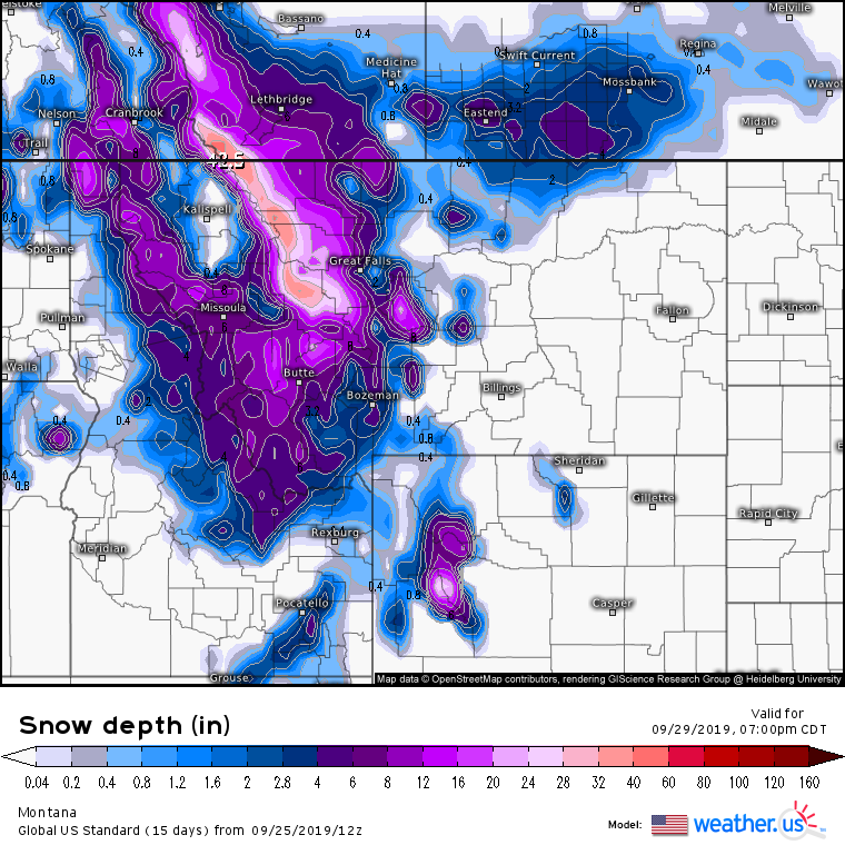
This really gives you a feel for the orography of western Montana. Looks like a foot for Butte, a half foot for Missoula, and 0.0 for the residents of the Flathead Valley/Kalispell. Not a great weekend to plan a drive on the Going-to-the-Sun Road in Glacier.
-
The really impressive winter storm looks limited to the northern Rocky Mountain Front, and the 2 foot + amounts will be driven by orographic lift, but I imagine the livestock loss and power outages will be severe. Fortunately, most of the relatively populated locations won't be getting the worst of it.
-
Joe, like a lot of public figures, has decided to be a publicity hound and hustler, rather than a scientist. I get that the reality of climate change is an extremely difficult thing to confront. Some people have made a lot of money off of hydrocarbon fuels, and that money has bought them a lot of power. Unfortunately, the negative externalities of their line of business affect a lot of people who have a lot less money and a lot less power, but who are told that they should be more scared of technological changes than climate change. If technological change is done right, the costs will be borne by the people who have made the most money -- and that isn't the "west" but the wealth hoarders who would sacrifice the lives and well-being of lesser people as long as they can continue to profit. I'm a middle aged, middle class guy, but I have a daughter who is two years old. I'll gladly make sacrifices now if it ensures that my daughter will live her life in a world with a climate that somewhat resembles the one in which my parents grew up and where I grew up. Thinking in a time frame longer than my own life has changed my outlook 180 degrees.
-
GFS has kept all of WNY above normal temps and very little precipitation all the way through Oct 4. End of September/ beginning of October shows downsloping sending the Niagara Frontier well into the 80s. Lake Erie is running +2 above average but by October 4 may be at a record temp for the date, so this year may be another data point to test the claim that a warm autumn results in more lake snow.
-
I live on a street lined with mature, healthy maples (mostly sycamore and Norway), and every one of them has had at least some color for about a week.
-
What an incredible trip. I have a friend who grew up in Cusco, that part of the world sounds like an amazing place.
-
How embarrassing for you to contort logic and language into an attempt to justify actions that are both authoritarian and unhinged. What hilarious is that you frame anticipated objections to your utter nonsense as an issue of “popularity,” as if you’re a brave truth teller instead of a coward who is willing to bend reality to the fantasies of a very powerful and very unstable man.
-
Sorry about your brain worms, get well soon
-
If someone posted a map like that on this website, they would get a weenie tag
-
There are a lot of weather hobbyists, and the hobby takes many forms, but some forms seem weird to me. Interest in chaser personalities is not my thing, but he has really cultivated an image and brand. I'm a little grossed out by referring to cyclones as "sexy" and "hawt" but clearly I'm not his audience. That said, you make a great point about how legitimately terrifying some hurricane videos are. Being trapped in an attic as the storm surge rises seems like a particularly awful way to spend your last few minutes on earth. But I was already convinced by the famous Katrina warning issued by the WFO in New Orleans that I would not want to be anywhere near a major hurricane.
-
He's a videographer, not a livestream chaser, so it's a little ridiculous to see all these prayers for him on Twitter. Getting online wouldn't be his first priority. To his credit, he hasn't tried to finagle a quick trip out of devastated areas in the past, when authorities are left counting the numbers of the living and seeing if civilization can ever be restored. Besides, he is enough of a showman to appreciate the drama of his re-emergence after a couple of days incommunicado.
-
No rain gauge, but I wouldn't be surprised at 2.5" or so in NE Buffalo. It was a Gulf Coast style torrent.
-
Colder than normal winters definitely are related to lake snow, but temperature variance at the beginning of October and November saw no relationship. I used the KBUF lake temp page charts for means and daily values. I'll look through old hard drives to see if I can find my analysis, but it's not difficult -- only requires about 200 data points.
-
I ran these numbers a few years ago, and IIRC there was no correlation between Lake Erie surface temp deviation from mean on October 1 and November 1, and seasonal snowfall deviation from mean. Lake Erie cools down and heats up efficiently because it's so shallow, so a "warm lake" in October might be a "cold lake" by late November or early December and vice versa. Even the October 2006 storm wasn't so much the result of a warm lake. It was +2F on the morning of the storm, but the lake temps have been warmer the last three years with no snow. The huge delta-t was due far more to the anomalous cold air aloft than a warm lake, which suggests that a cold October is something snow lovers would want. (I didn't do the same analysis on Lake Ontario because of the effect of upwelling on surface temps, but I suspect that there would be a stronger correlation.)
-
We’re lucky enough to have a stiff breeze off mid-70s Lake Erie. Not many other places without altitude are getting though this without some suffering.
-
Not much lightning, and only a 15 minute downpour, but the wind gusts as it came in were impressive.
-
Fri-Sun look awesome, sunny and warm with dews in the low 50s. Perfect weather. Warm temps here on Monday, but a chance of rain. Looks at or just below normal longer term, but it's still June.
-
July daily mean temp was +3F, August daily mean temp was +3F, September daily mean temp was +5F. Summer was warm, and persistent, which would have been great except for the grueling humidity that took the fun out of spending time outside. I'm hoping for a repeat of last year's temps, but with much more tolerable dew points.