tamarack
-
Posts
16,290 -
Joined
-
Last visited
Content Type
Profiles
Blogs
Forums
American Weather
Media Demo
Store
Gallery
Everything posted by tamarack
-
Only 25-26 years here, and the most recent 10 are almost exactly on the full-period average, though month-to-month varies: Jan avg +1.20 to March -1.17. The much longer POR at CAR is probably more characteristic, with only March BN (-0.43) and 5 months at least +3. Though a decade is just a blink of time when evaluating climate, that points toward warming. However, that says little about the next few months. Wind never fully quit last night, and the temp stopped at 12°, tied with last Tuesday for the month's coldest.
-
You had to bring up that one again. Most frustrating winter in my memory, for many reasons, but worse up north - the idea that BWI could have 7" more snow than CAR was mind-blowing. Also, CAR's temp for Jan-April must be at least one SD beyond that for any other year. That period in 2010 was 8.7° AN while 2nd mildest (2021) was 5.3° AN. This map perfectly conveys the snowfall distribution that I had in mind doing my outlook. The Farmington co-op averaged 104% of average for those 6 winters, but 4 of the 6 were BN with 3 at the edge of ratter territory. The 173% of 1968-69 (their snowiest of 130) skews the average.
-
Worked perfectly, thanks.
-
3.7" here that day, but the real events were the EF-0 and EF-1 tornados in the Georgetown area. Cold air and not a strong system, either - weird. Neither 95 nor 96 did we have measurable snow at our (then) Gardiner, Maine home. Biggest T-Day snowfall in our 13 years there was 3.7" in 1987. Biggest anywhere was 5.5" here in 2014, finishing a 13" dump, our only double-digit snowstorm in 70+ Novembers.
-
We had 2 days on Iceland as part of our Norway excursion in 2017 - no extra landing/takeoff cost from Icelandic Air, stayed at an AirBNB which was reasonable. Exchange rate was about 100 Icelandic kroner to the dollar and a good lunch (all the food there was good) ran 3000/4000 kroner. A year later it was about 140/$1, but we weren't counting kroner on that trip, just loving it.
-
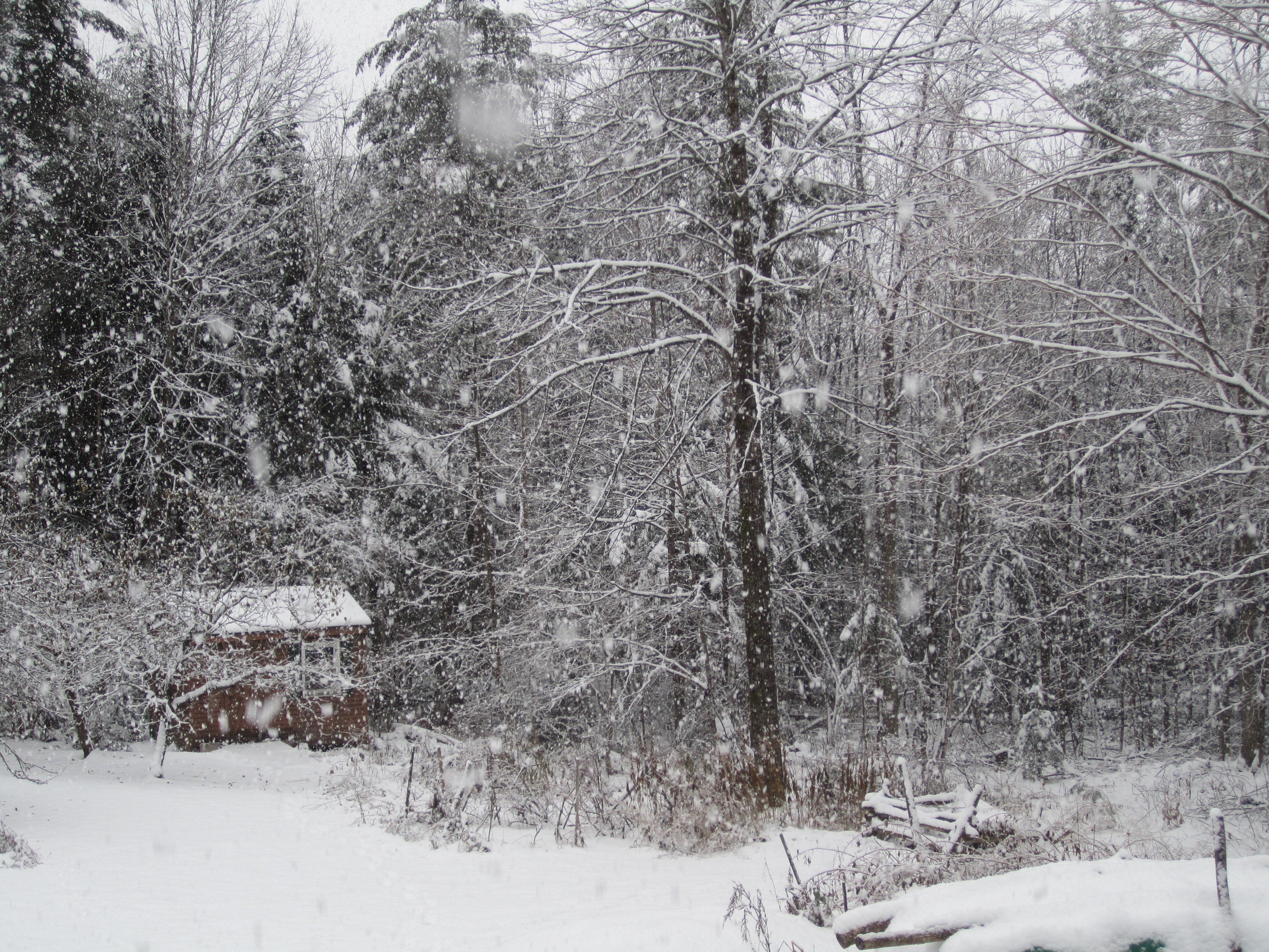
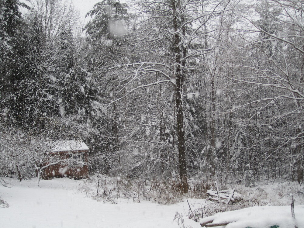
Other than rain, finished with 4.6" from 0.62" LE. The 2.6" by 7 AM was 12:1 and the 2.0" ending about 1:20 was 5:1 with much settling as it fell. Precip became white rain about 11:30 and I thought the fun was over, but then another inch of silver dollars fell in about 40 minutes shortly after noon. Pic was taken about 12:30.
-
Quite pretty at 8 this morning.
-
Had 2.6" with 0.22" with S- at 7 this morning. After 2 hours of very light snow particles, we had 1/2 hour of nice flakes (which just stopped) that brought the total to 3". The overnight stuff was broom snow; the later snow is quite wet.
-
Only got down to 12-13 here - we're usually within 4-5° of BML on good rad nights, instead of nearly 10° less cold. Latest clown maps put our area on the edge; 10 miles either way makes the difference between 1" and 6". With poor CAD, we'll probably be closer to the first number, but still end up with the ground being white.
-
3-4" would be nice, though the RA portion might turn our driveway into an ice palace. We're in the zone where 10 miles west or east would make a big difference in the GYX forecast percentages: Farmington's for 4"/6" are 59%/27% while at Skowhegan they're 27%/3%. Our place is about 6 miles from the former and 15 from the latter. Could go either way.
-
Single digits Tuesday morning at Estcourt Sta?
-
T-Day 2018 had a max of 11° here, and that was the temp at my 9 PM obs time the night before. Afternoon max was 9, following the -3 min. That might've been the coldest Thanksgiving in the past hundred years.
-
The Apps Gale vies with 12/31/1962 (backside NW gales from the blizzard than ate BGR) for the strongest winds I've experienced. That later date had temps 5/-8, pretty hefty WCI for New Jersey.
-
Cutter. Pittsburgh INT AP: 1950-11-24 41 11 26.0 -13.7 39 0 1.54 14.0 10 1950-11-25 23 7 15.0 -24.4 50 0 1.10 10.1 20 1950-11-26 23 9 16.0 -23.1 49 0 0.33 3.3 22 1950-11-27 29 16 22.5 -16.3 42 0 0.16 1.7 17 NYC: 11/24/1950 53 38 45.5 0.1 19 0 0 0 0 11/25/1950 59 36 47.5 2.5 17 0 1.59 0 0 11/26/1950 41 28 34.5 -10.2 30 0 T 0 0 11/27/1950 40 32 29 -8.4 29 0 0 0 0
-
My earliest weather memory. Dad, older brother and I stood on our back porch at our NNJ home, watching the trees thrashing in the wind. A couple tops broke off as we watched, and dad said it was time to go inside.
-
3.6 AN here, 3.2 at BOX and 4.7 at NYC. Some folks have short memories.
-
We had 30" of interior snows in 12/13, though no double-digit storms. Though we had last-minute dodges of several storms in 14-15, the pre-Thanksgiving event dropped 13" here, by far the biggest November snowfall I've seen. (2nd place is 8.5" in 1974 at BGR, 3rd is 8" in 1968 while in NNJ, surprisingly no top-3s in Fort Kent. A year after moving south from Fort Kent, they had 21" a few days before T-Day.)
-
Crazy man! (If I were 30 years younger, I would've been equally crazy.)
-
2020 was worse here, 2.5" rain and temp 28° AN, tallest AN day we've had here, 1° more than 3/22/12. Meh, get the front through and have a nice cold T-Day. As long as it's not T-Day 2018 cold, afternoon max near 10° with 40 mph gusts.
-
Not within the last decade, but 06-07 fits that description. The period Nov 8 thru Jan 13 (67 days) had only 11.0" snow and temps 8.0° AN. Jan 14 thru April 17 (94 days) brought another 84.3" with temps 5.3° BN. Result was a slightly AN snow season, and the only time I expect to see a storm (Patriot's Day) produce 5" snow and 5" rain. 03-04 was just the opposite, with the storms of Dec 6-7 and 14-15 totaling 37.2", which was 51% of the winter's snowfall. Yesterday's 34/14 was the first double-digit BN day since the nasty cold rain of June 4. Cloudy today but whatever might be falling is getting eaten by the dry air.
-
Very true, and the beginning of the end of agony came with Bill Parcells. Though SB-20 ranks only as the 5th worst beatdown according to advanced stats, IMO no other participant in SB history was so utterly overmatched. Also, Tony Eason must own the worst QB line in SB records, 9 dropbacks, 6 INC, 3 sacks, one a strip sack, about -25 net yards before Steve Grogan replaced him late in Q2. First day here with 40 HDDs this season, low of 14 and high 34 or 35. Ice 1.25" on the washtub, which is now emptied and under the porch, the snow scoop brought out to make room.
-
It works here, for our short (25 years) POR. Percent of average snow: OCT AN 105% OCT BN 95% NOV AN 89% NOV BN 114% Both AN 91% Both BN 105% O AN, N BN 125% O BN, N AN 87%
-
3.1° BN here thru yesterday and today will push that down a bit, but only 0.24" precip - month averages 4.27".
-
Reached 14 this morning with lots of frost, even on the branch tips 30 feet up on the fir I transplanted in 1998. (2 feet tall back then, now ~40 feet tall with branches spreading 20 feet wide.) Pure blue skies, a rare November treat.
-
Excellent news. Thanks for all the time you put in, so that we can enjoy watching folks' snow totals climb (we hope).