

tamarack
-
Posts
16,409 -
Joined
-
Last visited
Content Type
Profiles
Blogs
Forums
American Weather
Media Demo
Store
Gallery
Everything posted by tamarack
-
Nudging 20. Yesterday's max was 23 and we should top out in that vicinity. It was the first day with 50+ HDDs, my threshold for "winter cold".
-
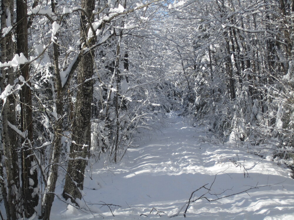
Takes lots of wind to topple bare-limbed hardwoods. I've seen it happen only twice - the Nov 1950 Apps gale and the frigid NW blasts of 12/31/1962. That latter event, the backside winds from the blizzard that ate BGR, probably gusted 70+. It smashed plate glass windows, uprooted 2-ft diameter oaks from semi-frozen ground (temps that day were 5/-8 at our NNJ place), and created 5-ft deep drifts from the 2" of paste that fell late on 12/29. We could see the gusts coming by the clouds of snow obscuring the upwind trees. Reached -8 this morning and might approach that again tomorrow. This is the 3rd straight day with essentially no wind. I can't remember having the trees remain this snow-loaded this long. Some high clouds drifting in but most of the morning was pure blue seen between the snowy branches. Spectacular.
-
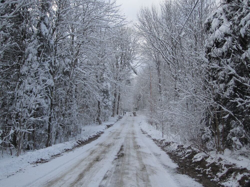
Hoping for big CAD Sunday night - won't turn rain to snow but would tone down the furnace Pic is looking down the unmaintained road just past the house. Note the pulley for our clothesline. No sled tracks since the storm, though one went by on much less snow after the Nov. 22 event.
-
First single-digit low this morning, down to 1°. I think our pack will take a hit Sun/Mon but will survive, especially as that snow -eater storm's appetite seems to be lessening, per recent models. Trees remain loaded though a decent wind would make it look like a blizzard. Looking down our road yesterday afternoon, the house is beyond this view.
-
That works fine for Special Agent Gibbs. Had 1.7" of 25:1 fluff from the IVT, much more than usual for those things here, for an event total of 12.4". Some Franklin County sites had upwards of 15".
-
BGR milder than any place outside of FL, HI, TX and SoCal. Of course. (But the Grinch won't waste his efforts 2 weeks too soon.)
-
I've used the ubiquitous 6-lb maul since installing a little Jotul in our first house, in 1977, though only for about 1/4 of our wood the past 4 years, with the rest purchased cut-and-split. That 1st maul had a hickory handle in a sledge eye and it lasted 3 years. I whittled a sugar maple replacement, which lasted one year, and the same in the following year, before making one from hophornbeam, aka ironwood. used that one for 2 years before my wife - noting the deformed maul head due to pounding on wedges - bought me a new maul, this one with an axe eye in 1984. I wrecked the original handle about 10 years later and handle #2 is still in use about 120 cords later. The old maul, with that ironwood handle, is used for pounding stakes and such. Trees are totally loaded with 10" new snow, which fortunately is about 11:1 ratio so no siggy tree damage.
-
So far, Franklin County is the winner, just like the mid-Dec dump last year. I don't mind a bit being the county's last place. 12/4/2023 7:00 AM ME-FR-23 Farmington 4.2 NW NA 11.0 NA NA NA NA NA ME Franklin Active | Static 12/4/2023 7:00 AM ME-FR-2 Temple 1.8 W 1.15 10.5 1.02 10.3 : 1 12.0 NA NA ME Franklin Active | Static 12/4/2023 8:00 AM ME-FR-26 Farmington 3.9 N 0.92 10.5 0.92 11.4 : 1 10.5 0.92 9 % ME Franklin Active | Static 12/4/2023 7:00 AM ME-FR-4 New Sharon 2.0 NW 0.84 9.2 0.84 11 : 1 9.0 0.84 9 % ME Franklin Active | Static 12/4/2023 7:00 AM ME-SM-4 Solon 3.9 ESE 0.54 9.0 0.54 16.7 : 1 NA NA NA ME Somerset Active | Static 12/4/2023 7:00 AM ME-KB-53 Readfield 2.0 NNE 0.62 8.0 NA NA 8.0 NA NA ME Kennebec Active | Static 12/4/2023 7:00 AM ME-KB-55 Manchester 0.5 NE 0.95 8.0 0.95 8.4 : 1 8.0 NA NA ME Kennebec Active | Static
-
If not, he was about the only one. PVD had only 7.9" but BDL/BOX/ORH had 11.5 to 12.5.
-
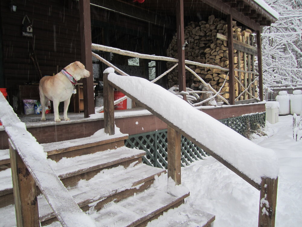
Our 55 lb Lab mix wondering when I will clear the driveway. Still some light snow after 9.2" from 0.84" LE. After a trace of rain about 12:15 PM yesterday, it's been light/moderate since then.
-
Late in Q2 a graphic noted that NE was 1-2 when holding opponents to <10 points, while the rest of the NFL was 50-0. Now 1-3, having scored 19 points in their last 3 games. I'd say their play was offensive but they don't really have one. First inch down, light snow currently.
-
Last December's big dump here was 9:1 and came at temps 30-31. Don't need 10:1 to have fun. Current forecast for here is 7-12.
-
That 1960 event dumped 18" at our place and the heavy snow was tapering off as we ventured out on the opener of the 6-day firearm deer season. After my friend and I waded thru the powder for 90 minutes, we came back to find my dad standing over a nice little buck, maybe 250 yards from our home. That storm was also remarkable for the cold, as much of the snow fell while the temp was low teens. The January blizzard was even a bit colder, so the biggest dog of all (Feb 3-4) felt mild as temps were upper 20s. March 1956 thru Feb 1961 had the best run of big storms I'll ever see. Even our years in Fort Kent couldn't match that NNJ run. Edit: Averaging the low end/expected/high end for Farmington and Skowhegan, our forecast is currently 4"8"/11". Would be decent.
-
My memory for the 1950s, especially the first 5 years, was different so I "had" to check (using Oak Ridge Reservoir as my old records are long gone). They had first-week storms of 8.0" in 1952 and 1957, and nothing else in the 1st or 2nd week bigger than 3.5". The '60s were better, with 4 events from 5.0" to 14.0", but only that 5" was 1st week. (Nov 1968 had a 7.0" event on the 12th, well remembered as we were nailing felt to an under-construction house well past sunset the night before. The windows hadn't yet been installed, and next morning the howling wind had covered the entire floor with white, even the interior hallways. NYC had to close the Whitestone Bridge for a while as the 60+ gusts were causing too much sway.) GYX had us getting WSW criteria Sunday night into Monday; should be able to see their new AFD soon. Edit: They've just posted a WS Watch for possible 8"+.
-
Last winter was awful for temps but just fine for snow here, and thanks to the big dump in mid-December, was AN for SDDs as well. Could've done without the 2nd mega-Grinch in 3 years, however. A nice thump in early December and no Grinch would be an excellent start.
-
November numbers: Mean: 31.0 -2.4 Avg max: 39.8 -2.5 Mildest, 52 on the 7th Avg min: 22.2 -2.3 Coldest, 11 on the 30th Precip: 2.63" -1.58" Highest day, 1.03" on the 27th Snowfall: 4.9" +0.3" 4.6" fell on the 22nd. Some pleasant (but small-sample-size) November temp/snow trends: 2023 was the 12th with BN temps. The previous 11 had 114% of avg snow, 9 had AN snow and 7 of our 10 with triple-digit totals came with November having BN temps. October 2023 had well above average temps. The 5 years with Oct AN and Nov BN had 125% of avg snow and all 5 were AN, though 12-13 by less than 2". I certainly hope the trends continue.
-
Another 2017-18 for those dates? Would be tasty - 2 big snowstorms and cold worthy of Fort Kent. Even a modest resemblance would be nice.
-
Some sites are far from the named town. An example is NH-GR-47, Littleton 7.3 W, probably in the next town. The lack of elevation can be confusing. I wondered why the Temple observer always had much more snow in marginal events than next-town Farmington or at my place - until I found its elevation was 1,224', about 800' higher than its neighbor's site.
-
That's true for "chronic" back puffs. However, certain wx can cause them even with the proper height. At our first house in Fort Kent, a small (18'x20') 2-story with 12/12 roof, we had a Jotul 602 - their smallest stove at the time - hooked to the center chimney. It furnished for temps down to about -20F, below which we fired up the leaky* old $20 parlor stove in the basement. The Jotul's thimble was about 25' below the chimney's top and back puffs were uncommon but always came from the same conditions, a windy CF following a mild day. I think the 70' tall balsam poplars just NW from the house would create turbulence, downdrafts in their lee that were strong enough to reverse the smoke for a second or 2. * I referred to it as being as tight as a lobster trap.
-
Can't argue about how bad last winter was for most of SNE, but your response to Ray, below, infers the same for this winter, with no evidence offered. Too early to throw in the towel. Posted 3 hours ago and the last 2 weeks and Jan and so on
-
Elmwood produces more warmth when one tries to split it than when it's in the stove. About the only wood worse is balsam poplar. In a lunchtime discussion about burning green wood among loggers long ago, one comment was, "You couldn't afford the oil it would take to burn Balm o' Gilead!" Two couplets from a poem about firewood: Elmwood reeks of muck and mold, Even the very coals are cold. Ash wood green or ash wood dry, A king shall warm his slippers by.
-
Gray birch, no strength at all. Mediocre firewood, too. The original "birch-bender" species - in the Jan 1953 ice storm in NNJ, my dad cut all the birch* tops from our road on the 8th, then had to do it again the next day as some additional trees had bent onto the road. Six days w/o power. * The "white birch" of NNJ were gray birch, except for the occasional planted paper birch.
-
We had close to 15" and mostly on the 24th. I'd gone partridge/squirrel hunting mid-morning in light snow, and when I got to the 345kv towers a mile south of the house, I could hear the flakes being vaporized by the lines. On the way home, game-less, the snow became heavy, and I heard a booming sound. While trying to guess what had caused it (because, of course, it can't thunder in a snowstorm), a second boom of obvious thunder corrected my assumption. That winter added up to about 100", the final 3 on April 27.
-
I don't recall that early Dec storm in 1957, though we must've gotten 8-10". It's the cold blizzard on Feb 15-16 and the paste bomb on March 20-21 that stick in my memory. The Dec storms I remember came in 1960 (of course), and the near-Christmas events in 61, 63, 66(!) and 69.
-
Had a sun-flurry for a few minutes before the clouds caught up to the windblown flakes. Dusted the leaves but no accum.


