tamarack
-
Posts
16,409 -
Joined
-
Last visited
Content Type
Profiles
Blogs
Forums
American Weather
Media Demo
Store
Gallery
Everything posted by tamarack
-
Octorcher or Roctober 2023 Discussion Thread
tamarack replied to Damage In Tolland's topic in New England
Birds love them - maybe a partridge in a dogwood tree? -
Octorcher or Roctober 2023 Discussion Thread
tamarack replied to Damage In Tolland's topic in New England
Not quite as extreme here - instead of BTV's +13 on Oct 1-7 then +2 Oct 8th on, it was +10 then -1 here. Looks like the next week here will continue dry and seasonable. -
Octorcher or Roctober 2023 Discussion Thread
tamarack replied to Damage In Tolland's topic in New England
Those yellow dots in southern franklin County really stand out, and they're the result of one relatively brief event. On the evening of Sept 13, Temple and 2 Farmington sites had between 3.25" and 3.35" in less than 3 hours, causing some localized washouts, while my gauge 5-10 miles east had only 0.30". Heading into town about 6:15, I wished for a 3rd gear in the wipers and had to slow to 15 mph, and the oft-seen puddle in front of Giffords and McD was quite deep as I slowly drove thru about 8 PM that night. -
Octorcher or Roctober 2023 Discussion Thread
tamarack replied to Damage In Tolland's topic in New England
Surprisingly little specific experience, though it's likely a significant factor in butt rot throughout the forest. I can't recall seeing the fruiting bodies as shown in the pic. Apparently, vigorous trees can often limit spread of the fungus and are thus tolerant, while stressed trees are quite vulnerable. -
Octorcher or Roctober 2023 Discussion Thread
tamarack replied to Damage In Tolland's topic in New England
Location, of course. Last winter's snowfall here was almost twice that of 20-21. A couple of sites in NW New Jersey had more snow in Feb 2021 than we had in that entire winter. Last winter's base was the big dense dump in mid December - even the 3.25" Grinch deluge a week later couldn't take all the snow away, just left us with 12" of glacier that withstood the mildest of 25 January's here. -
Octorcher or Roctober 2023 Discussion Thread
tamarack replied to Damage In Tolland's topic in New England
As a weather nerd and gardener, I track growing seasons and probably many others here do likewise. Tuesday morning was forecast for possible frost, and it never got below 37. This morning was forecast to be near 40 and it dropped to 32, with frozen dew all over the pickup except for the "cabbage leaves" frost on the hood. Frost free period was 139 days, 3rd longest of 26 here and 21 above average. All the frost-sensitive veggies had run out of gas so no real effect on the garden. 90%+ leaf drop, though the big (2' by 90') oak is still mostly green with minimal drop. -
Octorcher or Roctober 2023 Discussion Thread
tamarack replied to Damage In Tolland's topic in New England
Oct-Nov temps, correlation with snowfall here. Only 25 years but same trends in the much longer (130 yr) POR at Farmington: Temp Snow (% of avg) Oct AN 105% Oct BN 95% Nov AN 89% NOV BN 114% Both AN 91% Both BN 105% Oct A/Nov B 125% Oct B/Nov A 87% -
Octorcher or Roctober 2023 Discussion Thread
tamarack replied to Damage In Tolland's topic in New England
4 KUs: whiff whiff whiff 3.81" precip, 10" 4:1 mashed potatoes that splattered on landing plus 1.14" RA at 33-35, final result 8" with nearly 3" LE, harder to move than the 24" dump a year earlier. (While reading of NYC's "snowicane", 20.9" on the same NE wind that was blowing up here.) Maybe not the worst winter here, but definitely the most frustrating. -
Octorcher or Roctober 2023 Discussion Thread
tamarack replied to Damage In Tolland's topic in New England
In 1992 we lived in Gardiner, 35 miles SSE from our current home, and all we got from that storm was lots of wind and nary a flake. Also a plethora of white ash seedlings the following spring, as the bumper seed crop had been thoroughly distributed by the gales. Was down to 40 by 8 last evening but then the clouds began to filter in, so the temp only reached 37. Next week for 1st frost? -
The OL turned to crap in BB's 1st year here, and the resultant 5-11 finish brought in Richard Seymour. IMO, the OL issues are at work again and Mac has lost confidence in it, such that he hears footsteps even when they're not coming.
-
Octorcher or Roctober 2023 Discussion Thread
tamarack replied to Damage In Tolland's topic in New England
Is that the 1991-2020 average, or long-term. The median here is Sept 19 but for the last 5 years it's Sept 30. Temp was headed toward 32 under starry skies at 10 last evening, but clouds stopped it at 37. Probably frosts tomorrow morning. -
It seems strange, as they played close against 2 excellent teams in weeks 1-2 and were easily handling the Jets until late in the game. In that one, the failed tush-push followed by a 4th-and-1 fraidy-cat punt from the Jets' 45 seemed to take the air out of the offense and it's never come back. Then the D lost its 2 best players. Murphy is alive and well in Foxboro.
-
Octorcher or Roctober 2023 Discussion Thread
tamarack replied to Damage In Tolland's topic in New England
1.86" total, with about 2/3 falling 8-11 last evening. Jack was Penobscot Bay, especially the west side with some 5"+ totals. End of the 17-day dry spell. Other than the wind-shielded understory, 90% of the leaves are on the ground here. -
Can't get too interested until we get a frost. Today we passed 2011 for 2nd latest of 26 autumns, but I'm confident we won't approach 2021 when first frost came on October 24. Maybe if the wind quits Monday night?
-
Octorcher or Roctober 2023 Discussion Thread
tamarack replied to Damage In Tolland's topic in New England
If any car attempts to perform an Axel, it's likely to be more than axle deep. (Could not resist . . .) Only 0.05" here so far. The other 3 reports from Franklin County ranked 1,2,3 for Maine's wettest (though all were modest): Temple (2 towns west) 0.33", Farmington (next door) 0.28" and 0.22". My 0.05" tied for 41st most. -
Octorcher or Roctober 2023 Discussion Thread
tamarack replied to Damage In Tolland's topic in New England
Raking leaves today. Contributor trees are 80-90% bare and the leaves are extra crispy. 1-2" RA would make the job 10X harder. from Coastalwx: Lots of color on the maples all around. Norway's just turning brown and dropping. Oaks starting to turn orange, brown, and yellow, but lots of green on them still. My parents retired to Woodsville, NH and had a large (20" diam.) one of those European invaders next to their driveway. Its leaves would stubbornly stay green as the native trees peaked, then it would drop nearly all its leaves in a single day, still green. -
Octorcher or Roctober 2023 Discussion Thread
tamarack replied to Damage In Tolland's topic in New England
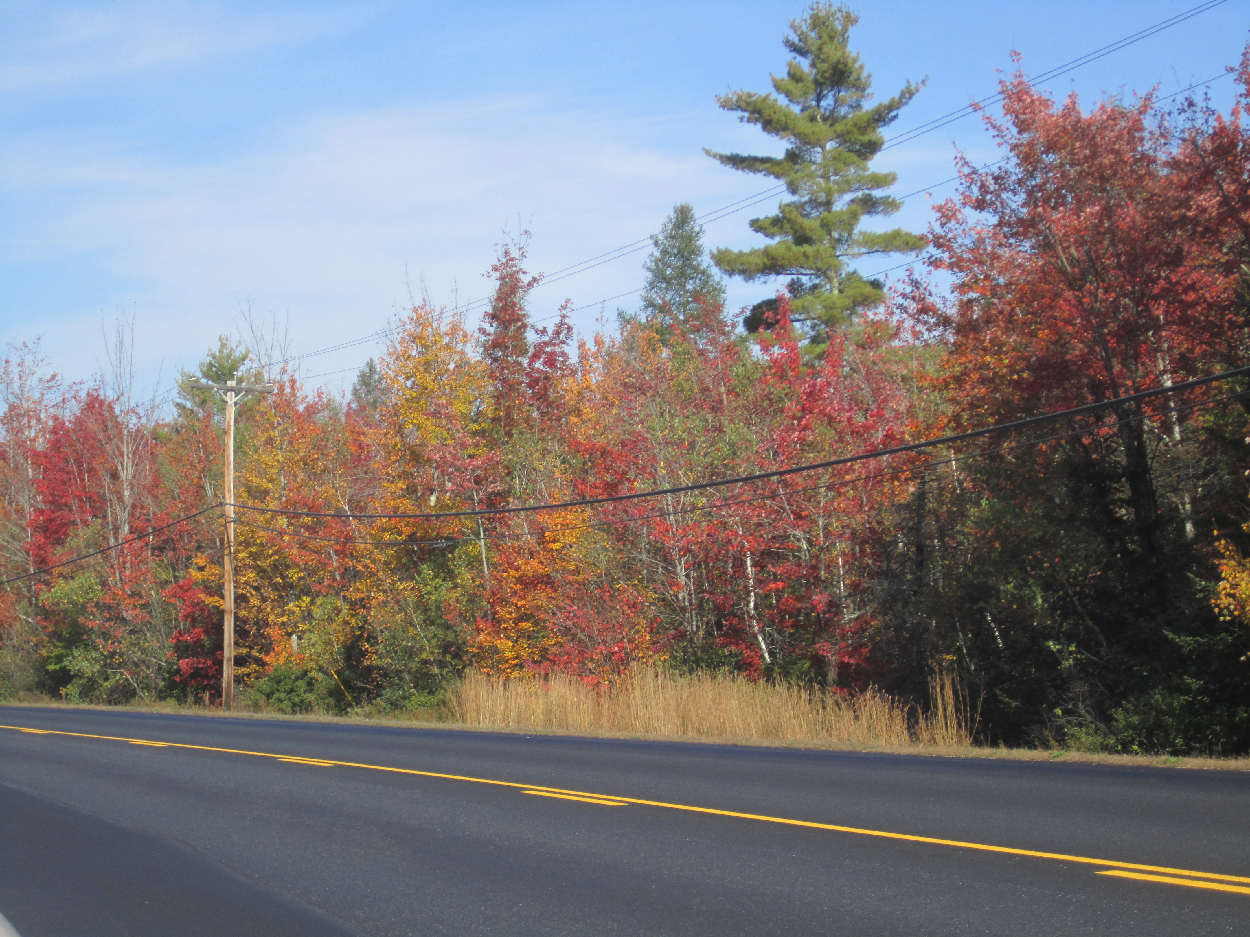
Yesterday was the 16th straight totally dry day, probably the longest such run I've had here, though I'm too lazy to look very hard for a longer one. I did look up September 2020, which had only 0.15" thru the 29th (and 1.14" in a howling NE storm on the 30th - ran the genny 10 hours, longest since installation). That month had a 14-day dry spell. Jan-Feb 2010 had a 25-day run with no measurable but with 5 trace days, one of which was a 0.1" dusting. In the 3 days since I posted the "Early Corner" pic at peak, we've had major leaf drop, now at 70% and near total where that pic was taken. All this with very little wind. I guess when it's time, it's time, weather or not. -
Octorcher or Roctober 2023 Discussion Thread
tamarack replied to Damage In Tolland's topic in New England
Many thanks. And because I enjoy deep-diving into wx history, it is especially sad when good long-term co-ops die. In addition to Farmington with its near-complete record (missing just 7 months in 130 yr and only 1 since 1909), 3 other century-plus sites have been lost since 2011 - Lewiston, Bridgton and Gardiner. This last is the only Maine co-op I've found with 3/1888 data. (They had 8" of paste with the day's temp 38/32.) -
Octorcher or Roctober 2023 Discussion Thread
tamarack replied to Damage In Tolland's topic in New England
At the local long-term co-op there's essentially no signal. Nov-May snow after an October with measurable snow is nearly identical to Nov-May snow following a snowless Oct. Octobomb was forecast to dump 12-16" here, verified at 4.5 and the rest of the winter usually did the same sort of thing. (Though Farmington's 8" is their biggest October snowfall, 1893 thru last Oct, when it went off-line. ) -
Octorcher or Roctober 2023 Discussion Thread
tamarack replied to Damage In Tolland's topic in New England
Yup. It's the "back-branch" needles yellowing (normally), not the branch tips. -
Octorcher or Roctober 2023 Discussion Thread
tamarack replied to Damage In Tolland's topic in New England
Newer - the ones that grew this past spring and summer. 2nd-year, the ones that grew last year and are falling off as I type. (There's also usually a few 3rd-year needles on the main stem.) -
Octorcher or Roctober 2023 Discussion Thread
tamarack replied to Damage In Tolland's topic in New England
That's a sick tree. The first-year needles are yellow, while this time of year the 2nd-year needles would be falling off and the 1st years' needles are retained. I see green 1st-year needles in the upper right and right edge - different tree? -
Octorcher or Roctober 2023 Discussion Thread
tamarack replied to Damage In Tolland's topic in New England
At my place, 12/23/22 began with an inch of mush followed by a deluge, total precip 3.25", unseating the super-Grinch of 12/25/20 for December's greatest precip. Last 3 Decembers have been seriously AN for temps. -
Octorcher or Roctober 2023 Discussion Thread
tamarack replied to Damage In Tolland's topic in New England
1 PM temps: PWM, 78 with S wind. Probably not today (unless the wind switches to SW soon) CON, 80 Outside chance AUG, 79 Tied, will break -
Octorcher or Roctober 2023 Discussion Thread
tamarack replied to Damage In Tolland's topic in New England
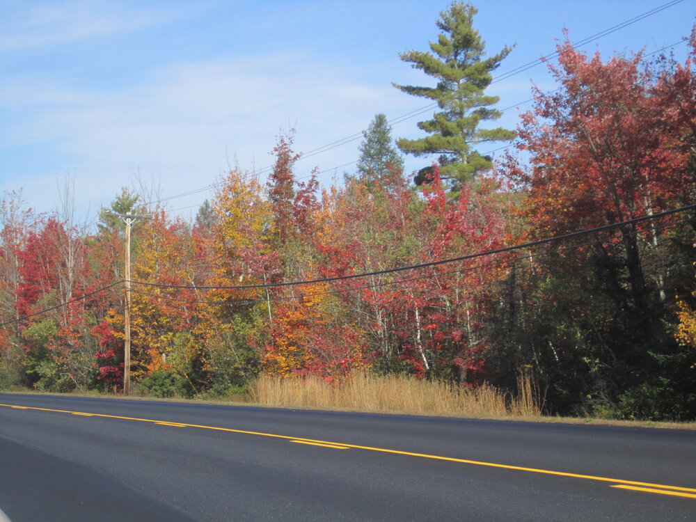
"Early Corner" along Route 2 in New Sharon. Poor drainage = early change.