Baroclinic Zone
-
Posts
47,702 -
Joined
-
Last visited
Content Type
Profiles
Blogs
Forums
American Weather
Media Demo
Store
Gallery
Everything posted by Baroclinic Zone
-

“Cory’s in NYC! Let’s HECS!” Feb. 22-24 Disco
Baroclinic Zone replied to TheSnowman's topic in New England
Still some lighter snows to go over eastern areas but ho-Lee-shit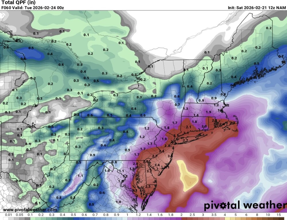
-
“Cory’s in NYC! Let’s HECS!” Feb. 22-24 Disco
Baroclinic Zone replied to TheSnowman's topic in New England
When your excited, we know it’s real deal. -
“Cory’s in NYC! Let’s HECS!” Feb. 22-24 Disco
Baroclinic Zone replied to TheSnowman's topic in New England
Seriously. 965Mb is yuge -
“Cory’s in NYC! Let’s HECS!” Feb. 22-24 Disco
Baroclinic Zone replied to TheSnowman's topic in New England
7mb stronger than 06z run. -
“Cory’s in NYC! Let’s HECS!” Feb. 22-24 Disco
Baroclinic Zone replied to TheSnowman's topic in New England
Hold me -
Maybe 1” here.
-
“Cory’s in NYC! Let’s HECS!” Feb. 22-24 Disco
Baroclinic Zone replied to TheSnowman's topic in New England
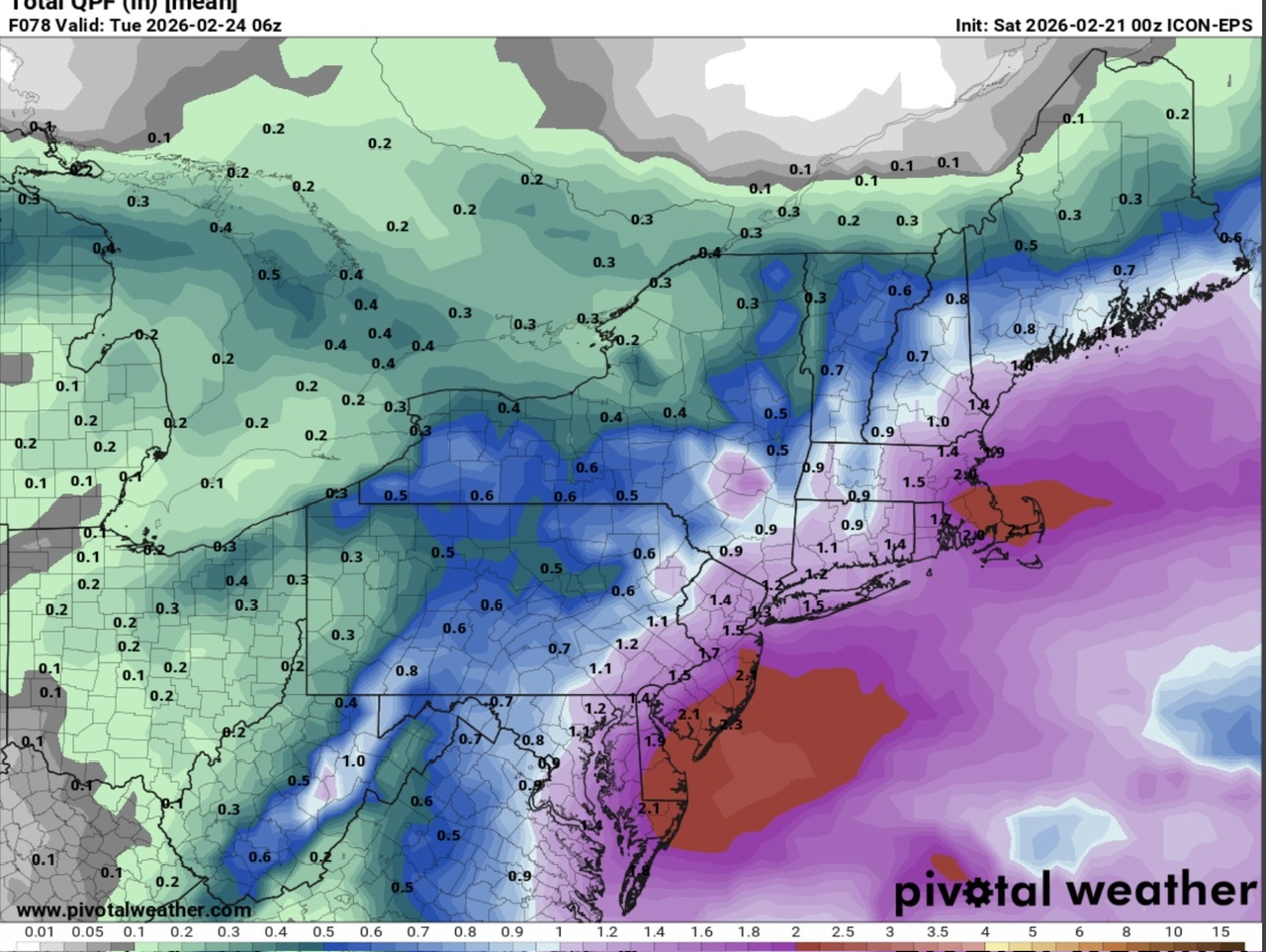
One thing to note is the 06z EPS mean SLP is coming in stronger than 00z by about 4mb. It’s also stronger than the 06z GEFS by about 6mb. Some EPS members are sub 970. -
“Cory’s in NYC! Let’s HECS!” Feb. 22-24 Disco
Baroclinic Zone replied to TheSnowman's topic in New England
AM all. Nothing more to add. Sitting pretty here in ASEMATT. 20” coming like it’s no big deal in the tropics. -
“Cory’s in NYC! Let’s HECS!” Feb. 22-24 Disco
Baroclinic Zone replied to TheSnowman's topic in New England
Keep in mind places north and west of BOS-BDL line are seeing precip. Down SE MA way we’re pretty much done -
“Cory’s in NYC! Let’s HECS!” Feb. 22-24 Disco
Baroclinic Zone replied to TheSnowman's topic in New England
Agreed. 00z GEFS are actually more robust than 18z GEFS.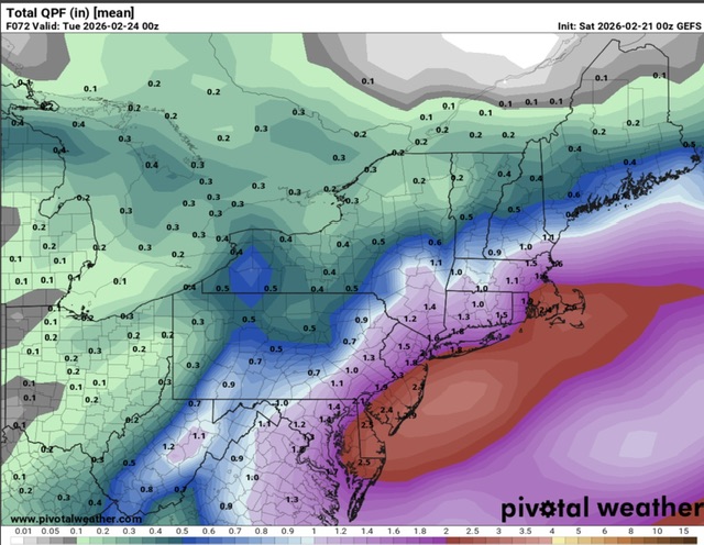
-
“Cory’s in NYC! Let’s HECS!” Feb. 22-24 Disco
Baroclinic Zone replied to TheSnowman's topic in New England
Still crushing ASEMATT -
“Cory’s in NYC! Let’s HECS!” Feb. 22-24 Disco
Baroclinic Zone replied to TheSnowman's topic in New England
AIGFS holding serve. No discernible difference from 18z. -
“Cory’s in NYC! Let’s HECS!” Feb. 22-24 Disco
Baroclinic Zone replied to TheSnowman's topic in New England

-
“Cory’s in NYC! Let’s HECS!” Feb. 22-24 Disco
Baroclinic Zone replied to TheSnowman's topic in New England
Reggie is gonna take its time to get there. -
“Cory’s in NYC! Let’s HECS!” Feb. 22-24 Disco
Baroclinic Zone replied to TheSnowman's topic in New England
I got the Jack! -
“Cory’s in NYC! Let’s HECS!” Feb. 22-24 Disco
Baroclinic Zone replied to TheSnowman's topic in New England
I’m sure you some home mange 12-18” of upslope as the storm shifts away. -
“Cory’s in NYC! Let’s HECS!” Feb. 22-24 Disco
Baroclinic Zone replied to TheSnowman's topic in New England
HRW-FV3. DAMN… check out the little spinner just off south coastline, north of min circulation.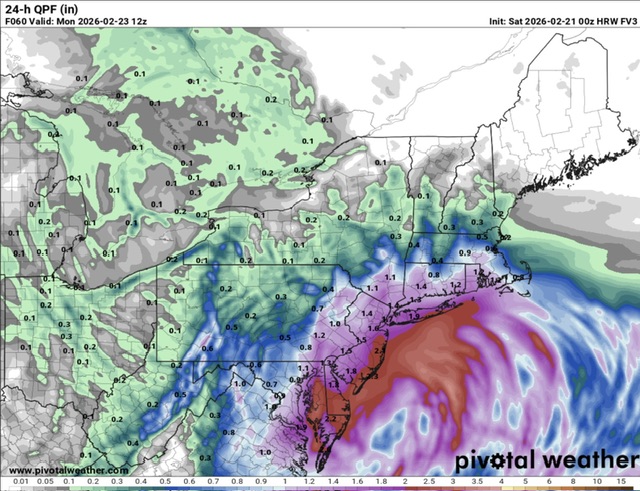
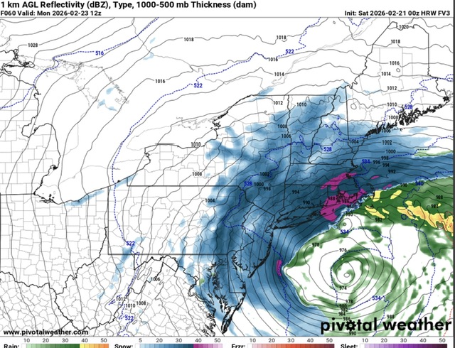
-
“Cory’s in NYC! Let’s HECS!” Feb. 22-24 Disco
Baroclinic Zone replied to TheSnowman's topic in New England
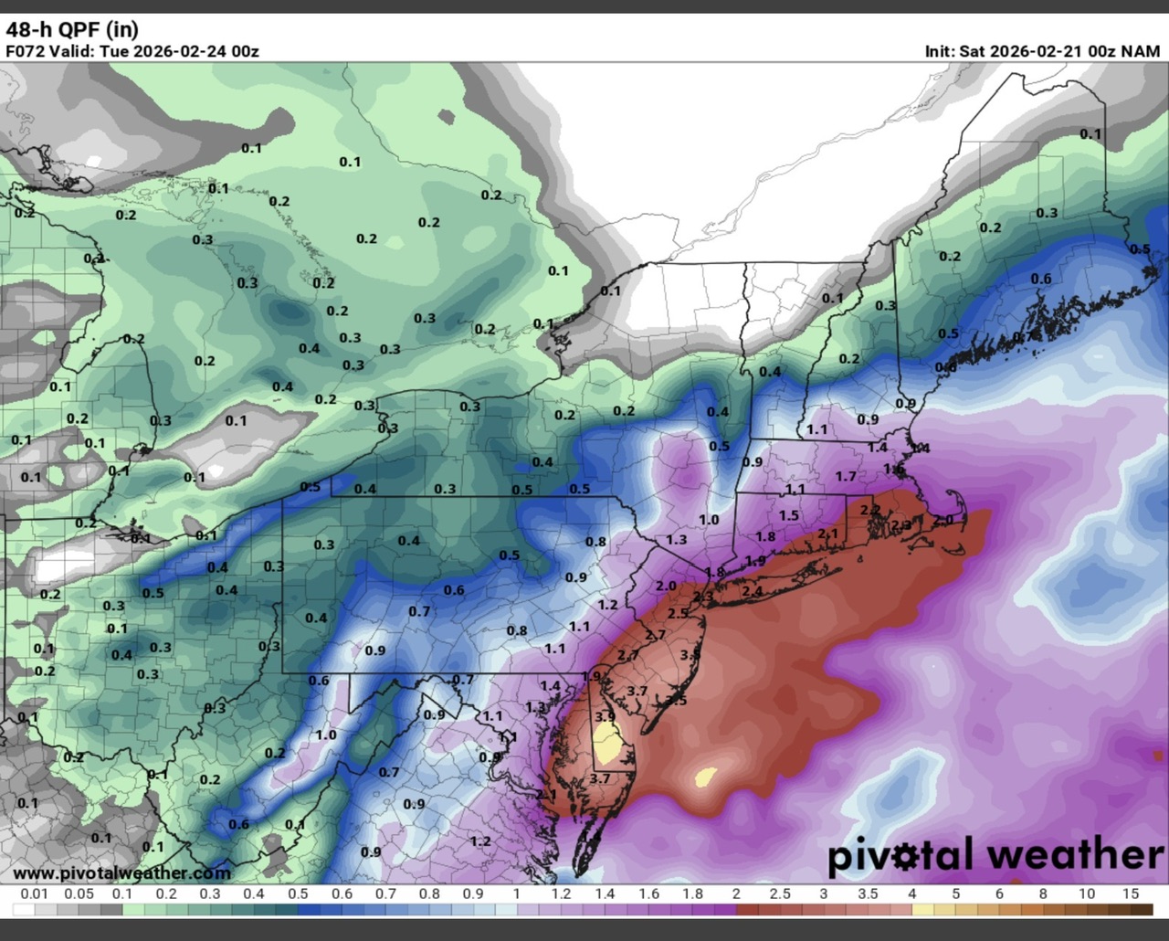
3km NAM thru end of run and plenty more storm to go.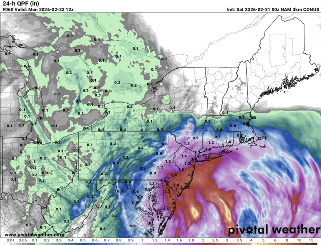
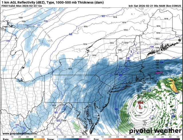
-
“Cory’s in NYC! Let’s HECS!” Feb. 22-24 Disco
Baroclinic Zone replied to TheSnowman's topic in New England
Been the trend today which bodes well. -
“Cory’s in NYC! Let’s HECS!” Feb. 22-24 Disco
Baroclinic Zone replied to TheSnowman's topic in New England
-
“Cory’s in NYC! Let’s HECS!” Feb. 22-24 Disco
Baroclinic Zone replied to TheSnowman's topic in New England
Yep. Top tier event looks to be unfolding -
“Cory’s in NYC! Let’s HECS!” Feb. 22-24 Disco
Baroclinic Zone replied to TheSnowman's topic in New England
Just a thing of beauty to watch unfold. -
“Cory’s in NYC! Let’s HECS!” Feb. 22-24 Disco
Baroclinic Zone replied to TheSnowman's topic in New England
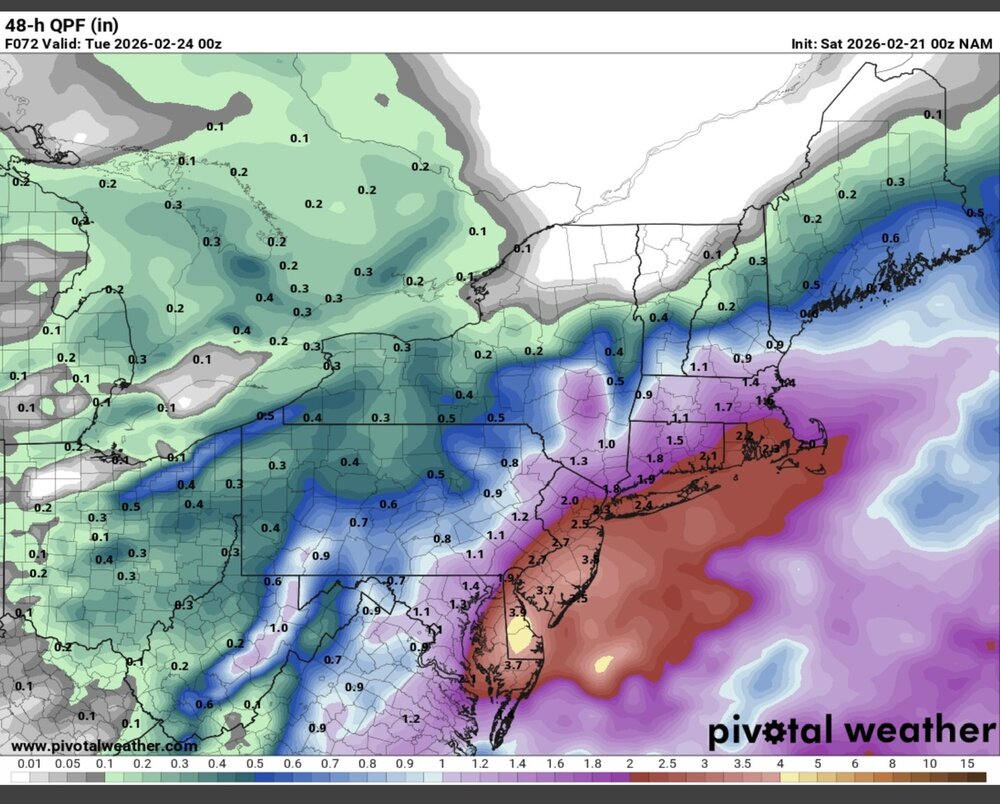
NAM gonna go off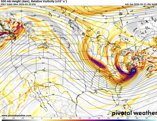
-
“Cory’s in NYC! Let’s HECS!” Feb. 22-24 Disco
Baroclinic Zone replied to TheSnowman's topic in New England
CBS Boston already going big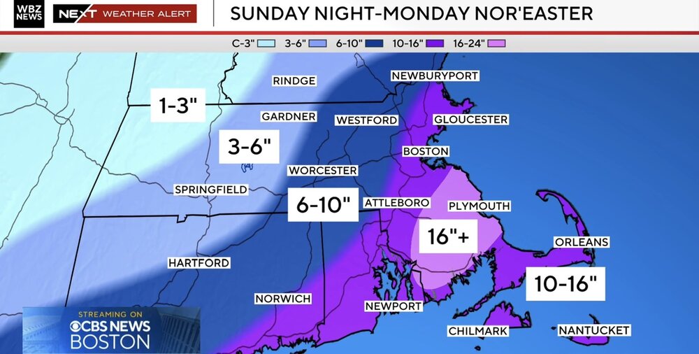
-
“Cory’s in NYC! Let’s HECS!” Feb. 22-24 Disco
Baroclinic Zone replied to TheSnowman's topic in New England
Gotta go big. I’m feeling 18-24”+ down this way.