

Dark Star
-
Posts
1,391 -
Joined
-
Last visited
Content Type
Profiles
Blogs
Forums
American Weather
Media Demo
Store
Gallery
Posts posted by Dark Star
-
-
48 minutes ago, TWCCraig said:
AI can only be so good as the data and observations that go into it. Less input data, more inaccuracy.
Clouds are holding back temps a bit here. Need them to thin out to get into the 70's here and 80's inland.
Media will always hire meteorologists to report the weather. The field, as I found out, is VERY small, so I don't think people go into it necessarily think they can land a decent job (at least they shouldn't). My one professor, Dr. Brotak even told us that back circa 1980. By that time, it was too late to declare a minor in something else. Dr. Brotak was let go a short time later. We thought it was for being brutally honest, that there weren't many jobs in the field.
-
 3
3
-
-
Too late in case Mount Spur erupts to cool things down for this coming winter?
-
11 hours ago, LibertyBell said:
This was not any kind of advisory event. We had like 2 hours of occasionally gusty winds and they died down before sunset.
I think the winds gusted like once every 10 minutes for 2 hours. Not even 50 mph here, maybe 40, but even that's pushing it.
Very unique, at least from my observation. The wind seemed stronger along the tree tops, but did not translate the same way down to the surface?
-
1
-
-
On 4/14/2025 at 7:39 AM, donsutherland1 said:
Since 4/13 18z, Caribou picked up 2.6" of snow. The next event of the two systems will bring very little snow and mainly rain/mixed precipitation. In contrast, the 4/13 18z GFS had shown the following amounts for snowfall during the period during which 2.6" fell: 10:1 ratio: 10.9"; Kuchera: 8.4"; and Snow Depth Change: 3.1".
I have finally thrown in the towel for any more chances of snow this season. It did look promising through February...
-
1
-
-
1 hour ago, LibertyBell said:
I just remember a lot more 90s in April occurring back in the late 70s (as you've shown with your data) and then of course we had 1991, 2002 and 2010. I think a few years ago we had back to back days in the 90s in April? Wasn't there some data posted showing that -NAO is becoming more common in April and May while +NAO is becoming more common during the winter?
One of the theories is that global warming took a recession, as some of the greenhouse gases were being absorbed by the oceans, which was used to explain some colder temperatures in the 80s?
-
1
-
-
1 minute ago, LibertyBell said:
They want to move south until they realize how crappy the summers in Florida are lol.
The 30 year norms also seem to give a perception that it's not warming as quickly as it actually is. I wonder how different the 1951-80 April norms are vs the 1991-2020 April norms.
We NEED to go back to use the complete historical temperature averages, not just the most recent averages.
-
5
-
-
On 3/28/2025 at 7:45 AM, MJO812 said:
AI

Was this the "stuff" that some areas got today (4/12/2025), just a little slower?
-
Some sleet mixed in, Garwood NJ, central Union County, NJ. Never precipitated heavy enough for snow. At 5 AM, nothing was coming down...
-
3
-
-
1 hour ago, LibertyBell said:
dry heat does not produce *swamp ass*
Feel free to conduct an inspection...
-
 1
1
-
 1
1
-
 1
1
-
 1
1
-
-
11 hours ago, LibertyBell said:
Unless they play opening day in a removable dome.
But this year opening day was March 27th, this is ridiculous!
Opening Day should be in the second week of April at the earliest. After April 10th!
Look, it's often warmer in November than it is in March or early April, why are they so opposed to having the playoffs cover the first half of November at least?
The season is too long. Opening in March is silly. At least this year, the Mets were on the road for the first two series. Extended playoffs pushing the World Series to November is not good either.
-
2
-
2
-
-
3 hours ago, Stormlover74 said:
Snowing at the Tigers Yankees game
Last year, the Mets were in jeopardy of having to make up a game missed early in the season due to weather. Unbalanced schedules and trying to pack too many games in, especially early in the season, is risky. They got away with it this year, so far. Opening Day series used to have an off day, just in case there was a weather cancellation. Too much money involved now to go back to a 154 game schedule.
-
1
-
-
2 hours ago, bluewave said:
+7 for the highs are still going to feel chilly in the early spring with the stronger winds, clouds, and rain.


So despite the alleged perception, the daytime maximum temperatures are more above average than the night time minimums.
-
13 minutes ago, Stormlover74 said:
Highs have been closer to average but lows have been warm with all the clouds
Closer, but most highs have also been above average.
-
1 hour ago, jm1220 said:
What an atrocious raw day. Other than the 4 hours last Saturday and some breaks of sun here and there where temps can spike, horrible last couple weeks. And it looks to continue.
Temperatures are way above normal...
-
5 hours ago, SACRUS said:
NYC
April 6, 1982 : 9.6 inches of snow
Must have been a steep gradient. Here in Union township of Union county, you can see much more of 10" here. I think it was around 16" here?
-
2
-
-
13 hours ago, lee59 said:
The strongest wind recorded in NYC was from hurricane Hazel as it passed hundreds of miles to the west, 113mph.
I think I heard two hurricanes in the early to mid 1900s (one might have been Hazel?) each cut a new inlet through the barrier Islands in New Jersey?
-
1
-
-
13 minutes ago, MJO812 said:
Way earlier
I have a poor memory. What was the last Categorical Hurricane to hit NYC? I'm thinking it had to be before Sandy? Sandy was devastating. Sandy was weakening as it was approaching New Jersey. I'm not sure how bad it would have been if it didn't run into that front. While ocean levels were elevated, and surely would have caused damage from the surge, that front caused it to strengthen, and the winds sucked everything violently inland. Some say it was a once in a 1000 year storm. I'm hoping so...
-
1 hour ago, forkyfork said:
at some point a hurricane is going to get pushed here
Every 50 years or so...
-
18 hours ago, snowman19 said:
I’ll take “Things that definitely aren’t going to happen” for $1,000 Alex
Like Friday night's rain?
-
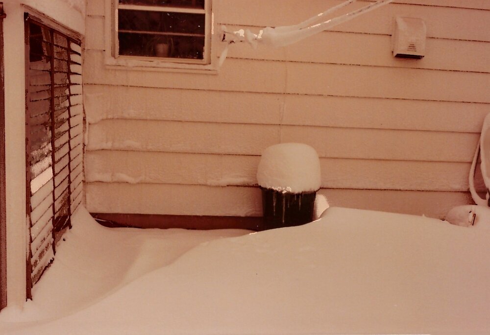
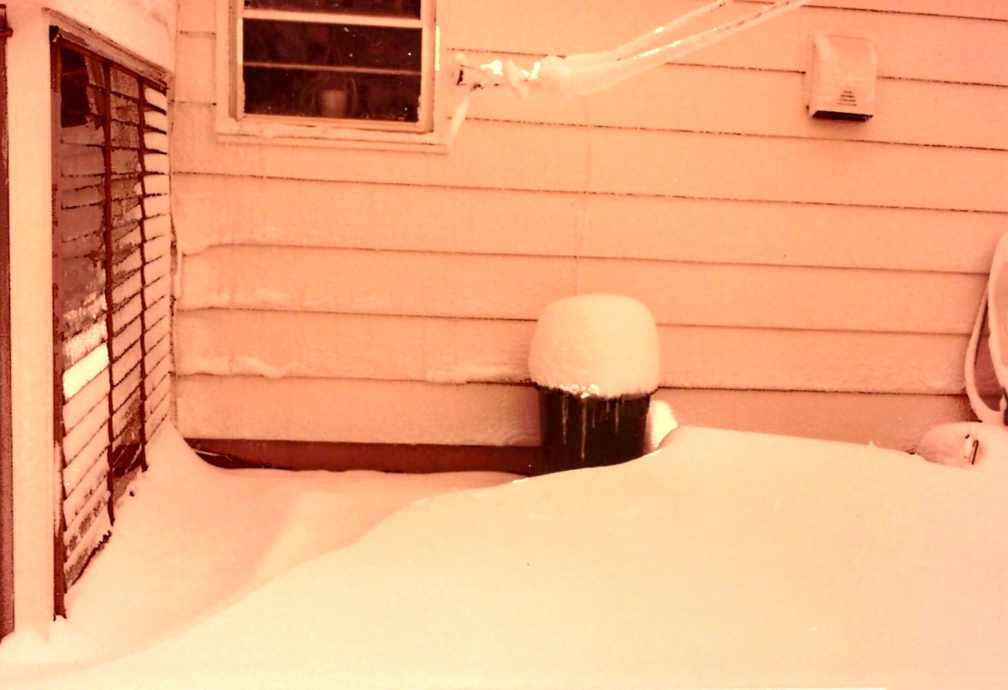
22 hours ago, SACRUS said:
NYC Easter Snow
April, 3 1915 : 10 inches of snow - largest of the season
I found an article where it said New York City received about 10" of snow in Central Park on April 07, 1982, nearby suburbs up to 20". These photos were from April 07, 1982 in my backyard in Union Township. Judging by the top of the garbage can, we had at least 12", probably more. Easter was on April 11, 1982.

-
3
-
 2
2
-
-
4 hours ago, LibertyBell said:
It's raining so hard here it could be a damn monsoon!!
Whomever said it wasn't going to rain were very obviously wrong.
I trust the forecasts put out by our local news stations much more than any individual model, because the news station forecasts tend to be right. Rain for the next 4 days, not all the time, but for a good percentage of the time.
Experiencing a deluge right now!
I just heard thunder too!
These short term precipitation models are sometimes as unreliable as the long term models...
-
1
-
-
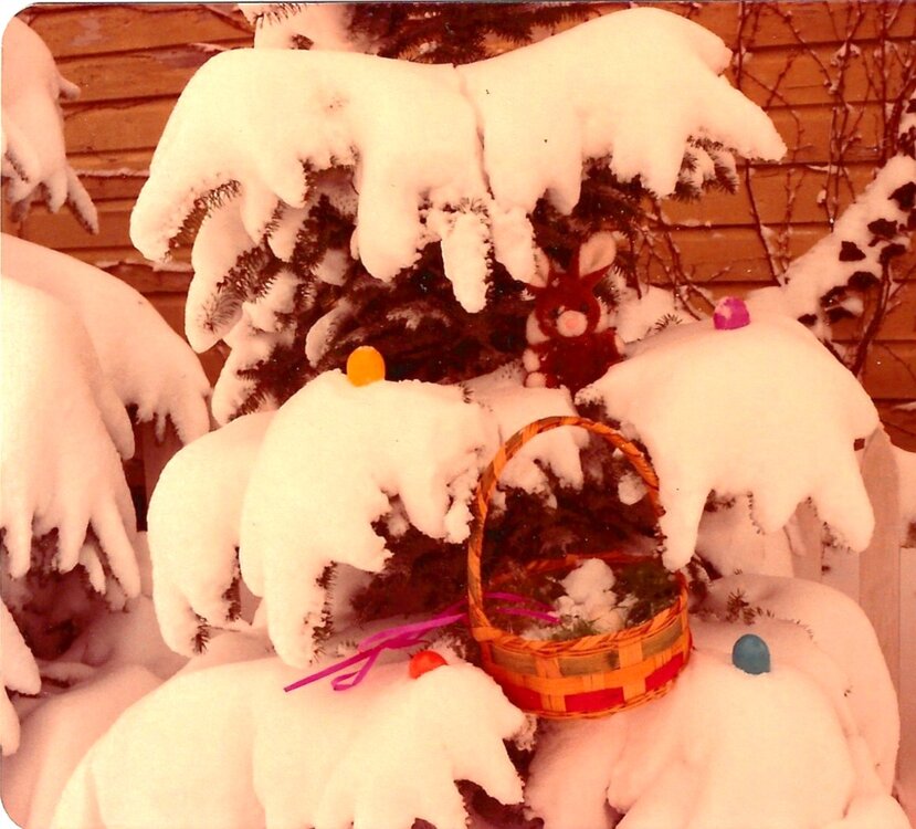
4 hours ago, SACRUS said:
NYC Easter Snow
April, 3 1915 : 10 inches of snow - largest of the season
Do you mean Easter proper? I do remember having at least a foot of snow on one or two Easters (Union County NJ). I even have a picture of at least one of them with Easter baskets in the snow. (Of course some Easter's do occur earlier).
-
1
-
-
4 hours ago, LibertyBell said:
I'd worry a lot more about historic flooding. No one deserves what the midwest and south are going to get over the next few days.
I could think of a few areas that might "deserve it". I think we would need a hydrologist to chime in on this. NYC proper has their water source in reservoirs about 125 north of the City. I would suspect that these "reservoirs" are fed from a massive drainage system, perhaps reaching as far as the Great Lakes and the Adirondacks? I have seen some reservoir levels in Jersey get mighty low, but many of these are "connected", meaning some are drawn down to feed other ones in times of drought. I do hate when we do reach actual drought conditions, that only people who hire landscapers are allowed to water their lawn.
-
1
-
-
43 minutes ago, gravitylover said:
I guess you don't live somewhere with lots of tinder dry brush and trees... Things were bone dry up here and now with everything leafing out and greening up, if we don't sustain at least average precip for the next month or so we'll go right back to dangerously dry with high fire danger. But, you can go on thinking that way and we'll listen to you tell us how terrible it is for allergies while we are concerned with the next brush fire that might be in our neighborhoods.
You are both correct.
-
1
-


April 2025 Discussion/Obs
in New York City Metro
Posted