

Dark Star
-
Posts
786 -
Joined
-
Last visited
Content Type
Profiles
Blogs
Forums
American Weather
Media Demo
Store
Gallery
Posts posted by Dark Star
-
-
2 hours ago, brooklynwx99 said:
we don't need Arctic air to snow... you just need near normal, and ensembles have us near or below normal by the end of the month. Canada can be +10 and it doesn't really matter for our intents and purposes down here
>95% you won't get snow with Pacific air...
-
22 minutes ago, binbisso said:
Yeah I don't get it. By January 1st were starting to get to peak climo. Who wants 15° for a high temperature and 0 for a low? We don't need that. We need a favorable 500 mb Pattern with storm sliding on south of us, which is exactly What guidance is showing. Otherwise it's congrats Richmond.
Except you don't want Pacific air to our north either...
-
 1
1
-
-
27 minutes ago, winterwx21 said:
3.58 here so far. Moderate rain right now. Back edge moving into western NJ, so it's almost over. Haven't had any significant wind.
Usually the "back end" of storms don't produce much, if anything. This one is an exception.
-
10 hours ago, wdrag said:
Just want to pass this on: There is no doubt in my mind about moderate to major impact for virtually all our area Monday, with power outages and moderate to major flooding of some streams lingering into Wednesday. 90-100 knots of 850MB wind over NYC-LI se New England for 3-6 hours tomorrow morning has to cause a fair amount of power outages (80 knots at 850MB in WAA is my trigger). Additionally, if your sump needs electric, better think about safe options.
Safely: your gutters that might be leaf clogged, might be good to clear the dgutters-downspout ingest area now... again you are your own best safety. Can't risk a falling off a ladder or roof.
The Passaic and Ct River are ensemble based (NAEFS and GEFS) qpf forecast to go into moderate or major flood stage Tue-Wed at couple of locations and many streams seem destined to go at least minor, providing the reality of 3" is realized. That is going to mean problems for those of you near these, detours etc. Again: this only occurs if 3+" falls in the basin. I continue to think spotty 5" in 18 hours by Noonish tomorrow. Follow hydro briefings from the various NWS offices and post here if you wish. My main concern is the SPC HREF has been lagging on this 3+" amount... I'd like to see this 12z run beef up to at least 3" basin.
Now is the time to getable preparations done, before nightfall and before rain-drizzle becomes widespread with the damage developing toward dawn Monday. I'll be up monitoring wind reports early tomorrow and as best I can rainfall reports.
Finally: the snow for Tuesday... in and out on the various models but don't count it out and early in the day. 12z/17 NAM and HRRR still have it. The 00z EC did, but lost it at 06z.
Interim, especially 18z GFS cycle are not recently deemed as reliable compared to other cycles.
I guess it depends on exactly where the systems merge. At first glance, it looks over NYC, but, it may be further east, depending on the speed?
32 minutes ago, PuraVida said:Go to bed now, wake up 4am
.Possible Dry Slotting around 4 AM?
-
1 hour ago, MJO812 said:
There hasn't been one yet lol
I thought you need a freeze to go into a thaw. Normal -0.5 degrees to +0.5 degrees is not a freeze to come out of to go into a thaw?
-
1 hour ago, 40/70 Benchmark said:
I feel like there will be another thaw in mid January as the energy flux makes its way from the troposphere to the stratosphere...then the most favorable stretch is in February.
Another thaw?
-
1
-
-
30 minutes ago, coastalplainsnowman said:
Thanks as always Don.
While the general point being made here and elsewhere about the rarity of snowfall immediately following a 60 degree December day makes sense, I was struck in a different way by this data: I was surprised to see that there's such a population of 60 degree December days going back to the late 1880s that we actually have a subset of five such days followed by snow to even talk about. Prior to the crazy run of 60 degree days popping up in mid December for most of the past 12-15 years, I'd only remembered one such warm day in the 80s, and always assumed 60 degrees in December to be exceedingly rare prior to that point, but that doesn't seem to be the case.
Actually I seem to recall numerous 60 degree days followed by snow. However, in those cases, there was cold air behind the warm air to pull down for saccumulating snow to occur. Gotta love the "sun angle" though...
-
1
-
-
3 hours ago, gravitylover said:
There used to be a ski area with rope tow in the park.
The NYC metro area has become too litigious. Seems (almost) nowhere allows skiing, skating, sledding...
-
1
-
 1
1
-
-
1 hour ago, MJO812 said:
No we aren't
Yes, we am...
-
 1
1
-
-
37 minutes ago, 40/70 Benchmark said:
I think what I did poorly with is identifying the Pacific jet as primary cause of the warmth...instead opting to articulate it as "western troughing" and "cool ENSO atmospheric momentum".
I could have done a better job conveying that. My understanding of the Pacific jet isn't great...I need work there.
I would tend to agree that the Pacific Jet IS the cause of our warmer weather here in the Northeast. As long as that is persistent, it will result in warmth in our area, and probably lack of cold air into Canada. I guess we could argue the ancient Chicken and Egg controversy? We will continue to see "colder signals" constantly postponed, until it is March, with perhaps an occasional ebb where some cold air will reach the NYC area.
-
1
-
-
1 hour ago, nycwinter said:
underachieved in manhattan from the rain and wind..
Agreed. Same here in Union County NJ. Most of NJ "spared" as a rational forecaster might have expected. Winds near and around the ocean is almost always another story. Windspeeds, at least for a storm, are almost always "over blown" for NYC and western suburbs. Mixing usually inhibited by friction. Over the immediate coastal areas, the winds could be realized. Just another rain event. Heavy lines were east of most of NJ.
-
1 hour ago, vegan_edible said:
looking through ensembles and im not necessarily seeing some sort of blowtorch scenario unfolding, just 40's and seasonable air through the holidays. i dont know the extent of which this will hold but the big 3 (GEFS, EPS, CMC) all seem to have us locked in on that look. 12z OP GFS seems to allow some cooler air to flood in after the storm on the 18th, obvious take that with a *big* grain of salt but i feel as though this winter is not gonna be all doom and gloom and we do have the have chances to score with january climo
We're wasting "sun angle"
-
2
-
5
-
-
1 hour ago, lee59 said:
As far as snow goes, an over performer in the DC and Baltimore areas. Many places getting about an inch. Would be nice to see it happen here.
Almost never, but the models love to tease us...
-
3 hours ago, the_other_guy said:
I wonder how many people canceled plans today based on the storm hysteria. Most of this will come while we are asleep.
Looking like NJ misses the most intense lines?
-
1
-
-
Looking like NJ dodges the heaviest lines...
-
2 hours ago, wilsonvoid1 said:
7am we snow in the city Monday morning?
.Always a possibility, but if I had a dollar for everytime models showed snow on the backside of a system, well, I would have money...
-
2
-
-
20 hours ago, LongBeachSurfFreak said:
That’s the thing, your going past Calc 3, and into the world of differential equations and discrete
math. My roommate in college was a math wiz and couldn’t handle discrete math. It’s when the formulas fill the blackboard. That’s really what it takes for a meteo degree. Personally I think it’s super archaic. Understanding the bigger picture should be what it takes, not doing equations with a slide rule.
I was horrible at math and had to take remedial math in college, but made it through Calc 4. I think the multiple blackboard equations were not necessary. If you wanted to advance the science, then yes, or if you wanted to program for the models. My head spun for sure, but luckily, many of my professors could notice that glazed look and call on me to bring me back in. I didn't stay in the field long because I didn't want to work nights for minimal pay or have to work for free for over a year as an intern. One of my professors suggested to the class to minor in meteorology, as the field was pretty small and not well paying for the effort in education. He did not last too long after that, but was a heckuva synoptic meteorologist!
-
56 minutes ago, LongBeachSurfFreak said:
I’d take March 1888 over that in a heartbeat. Hands down the greatest blizzard in our region in the last 200 years. Based on what I have read the snow in the park was way under measured. It was likely our largest total of all time using modern measuring. The pics of tunnels cut through drifts in Brooklyn are on a level we have never seen. Hurricane force gusts and 30”+ totals.
I was too young to remember, I guess...
-
2 hours ago, JustinRP37 said:
Also when did it become necessary for us to have extreme arctic cold for snow? Usually when we are putting up significant cold anomalies here it is very dry air.
Except you CAN'T have snow without cold air. Oxymoron? Contradiction? Would rather have cold and take my chances that the timing is right?
-
1
-
-
3 hours ago, LongBeachSurfFreak said:
Not sure why you you’re not grasping what I’m saying. Pre 1980s there was significantly more sea ice in the fall then there is now. As the summer melt out now exposes more area to solar insulation. Thus warmer fall/early winter temps in the Arctic our obvious cold air source. The Arctic Ocean still freezes over each winter though, and the darkness allows to cold to reload later in the winter. Thus exposing us to better source airmass’s later in the winter.
Yes you are correct, a frozen arctic would make things colder. My bad, I thought you had some inside information that the ice caps would be returning to more normal coverage.
-
3 hours ago, LongBeachSurfFreak said:
I think it’s a feedback do to lack of sea ice. Once the Arctic freezes back over, cold air is able to build. I think it’s at least part of why we have been seeing winters become increasingly backloaded.
I'm confused. Is the Arctic supposed to re-freeze anytime soon? Did I miss something? I hope to see it.
-
2
-
-
13 hours ago, Allsnow said:
Deja vu?
-
1
-
-
Happy First and last day of Meteorological Winter. Just kidding. I'm sure there will be a 2-4 day period where the mercury stays below 32 F.
-
9
-
 1
1
-
-
On 11/27/2023 at 3:52 PM, Volcanic Winter said:
2-4 per millenium. 2x per thousand years is the most commonly cited figure, but IMHO it’s a poorly constrained figure with a very low absolute sample size.
If you expand the field to ‘borderline VEI 7’ events, or eruptions with total eruptive volume around 75-90 cubic kilometers (ten shy of a VEI 7 and functionally indistinguishable), it’s closer to at least 4 per thousand years. Do be mindful of if literature speaks in terms of DRE (dense rock equivalent) or tephra volume, sometimes it’s not clear which figure a paper is referencing. It varies but generally tephra volume is 2.5x the DRE, and for purposes of VEI ratings you normally look at the bulk tephra volume.
1000CE to present you had Samalas / Rinjani in 1257 (a bit larger than Tambora even), Tambora in 1815, and possibly the poorly constrained and still debatable Kuwae eruption in the 1450’s, which was possibly very, very large.
Going back into the 10th century you have the Millenium eruption of Changbaishan / Paekdu Mountain which was a borderline 6-7.
Very tricky to answer. Different sources will offer different opinions.
Takeaway: they’re really not that rare. The next could be right around the corner…
Don’t forget in 1808/9 we had an unknown massive eruption (or series of clustered very large eruptions) just before Tambora, with its own massive sulfur spike showing up in the ice cores. All part of why the 1810’s were one of the coldest decades in human history. Talk about improbable, but speaks to how potentially frequent large eruptions can be (frequent on a century to century basis).
I wonder if there are graphs or charts showing the world wide temperature effects based on volcanic actiivty over the last 200 years?
-
1
-

December 2023
in New York City Metro
Posted
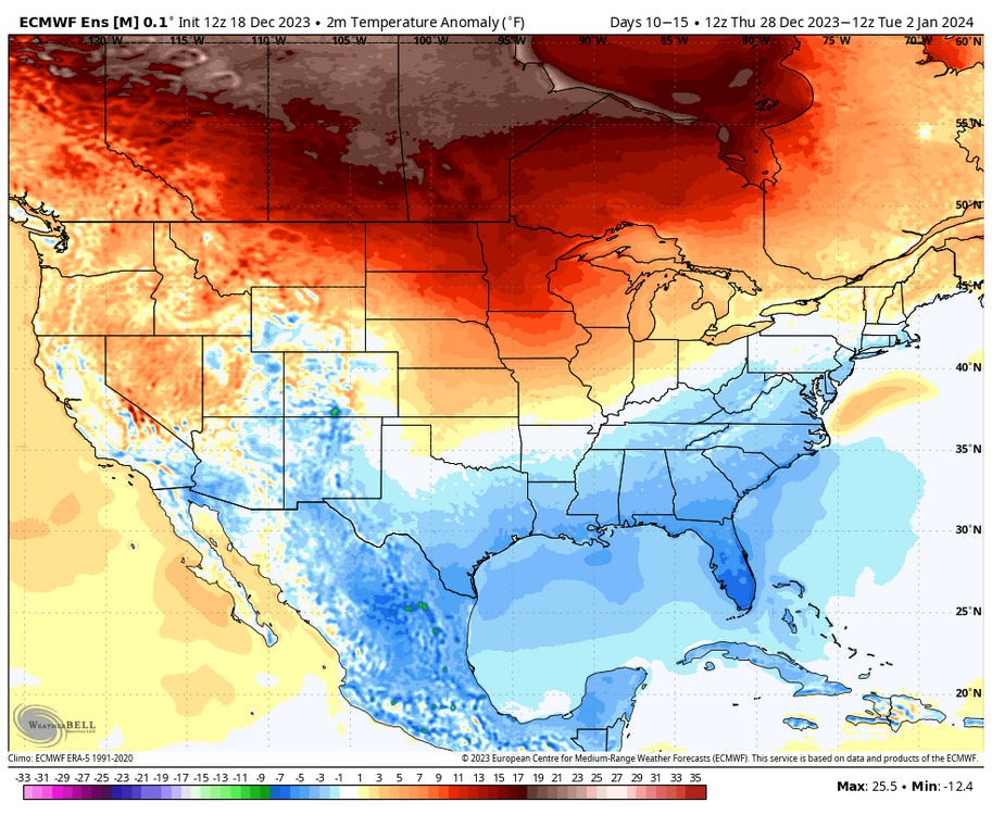
Sadly, this is not true arctic air, as the Pacific jet is pumping warm air all the way into Canada.