

Dark Star
-
Posts
1,386 -
Joined
-
Last visited
Content Type
Profiles
Blogs
Forums
American Weather
Media Demo
Store
Gallery
Posts posted by Dark Star
-
-
On 2/13/2024 at 5:28 AM, nycsnow said:

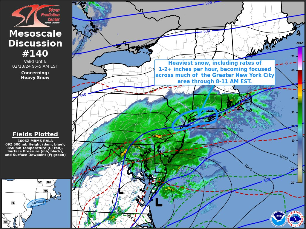
Wrong. Snow hole. By the time this was published, the heaviest snow was already over (for the area highlighted).
-
 1
1
-
-
34 minutes ago, MJO812 said:
17 years ago today , we had the big storm. I got 5 inches of sleet with temps in the teens .
February 14, 2007 I have listed as a mix of light snow, sleet and freezing rain (maybe 1.5" total sleet snow accumulation)? My notes show that a low was forecast to move into the Great Lakes, but rather slid across southen PA. A secondary formed off the Carolinas and moved north. Heavy snow warnings posted, but warmer air worked its way into mid levels, resulting in a mixed bag. Is this correct? I think the 5.5" sleet storm occurred March 17, 2007?
-
51 minutes ago, Stormlover74 said:
Nyc snow hole aside it shows how hard it is to get 2 awful winters in a row. At least this one is just bad so far and I'd imagine places like Sussex and orange are at their seasonal average to date. Allentown is close
Sounds like the NYC snow hole was worse than mine. Even with a perfect setup, and radar showing the heaviest yet to come, it cut off anyways. That's why I say, snow is a miracle in NYC metro area.

-
1
-
-
6 minutes ago, EastonSN+ said:
We can't complain this year, we performed far better than 97/98 even if we have seen out last snow!!
Avoided first back to back sub 10 inch seasons in my lifetime. Sitting at 12.5.
More than I expected with what looked like a relentless Pacific jet throwing heat into Canada...
-
2
-
-
11 hours ago, SBUWX23 said:
If we had been in the 20s that would not have happened. It's impressive enough that we had the cooling we did without the nice high to our north.
The region was cooler than what was originally thought. When it was first progged, the storm was going to start on Monday. The slight delay allowed more colder air to reach the northeast. Not enough for an ideal setup, but enough to hold off any mixing issues, even with lighter rates over the subsidence (or whatever) over Union County in New Jersey (although I don't know if anybody noticed, the last 10 minutes of precip appeared to end as a light drizzle)?
-
1
-
-
11 hours ago, Kaner587 said:
The biggest issue I noticed was when rates slipped below 1.5/hr then compaction starting eating away at totals. In the period from 8am-10am and then again 1115-1pm totals rapidly increased but between 6-8am and 10-11;15 despite decent rates it barely kept up with compaction
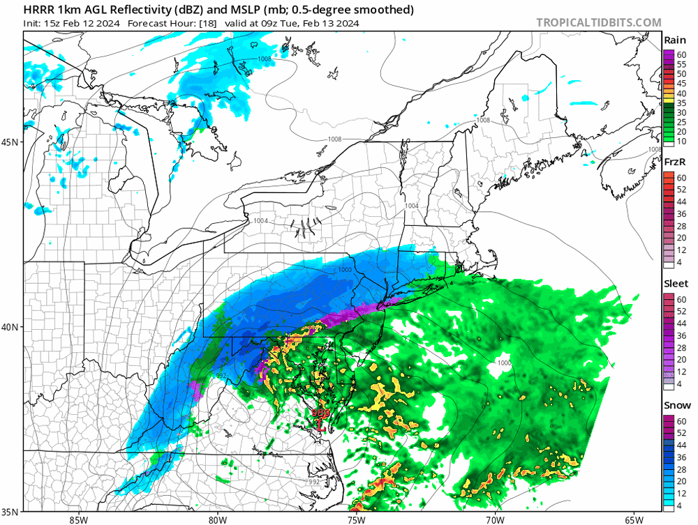
Compaction was not the issue in Union County, NJ. Based on modeling, predictions and the actual storm setup, Union County was going to be in the bullseye. Up until 8 AM, we had about 3" on the ground with the "heaviest" rates yet to come. Instead, during the 8:00 AM hour, the "Subsidence/Snow Hole/Screw Zone" set up over this area, reducing the snow rates. Snow never compacted (appreciably) during the storm here. At the very end, the last 10 minutes of precipitation, it appeared to be falling as a drizzle. Immediately after, the snow became wetter, began melting and true compaction begun.
-
2
-
-
19 minutes ago, NorthShoreWx said:
744 days was a pretty good run.
I think all the storms and misses have been challenging over the last several years...
-
1
-
-
1 hour ago, RU848789 said:
Yeah, just saw that too; wasn't mine as I had 6.0" and didn't report it yet (I usually do post them on the NWS FB page - sometimes they get used, sometimes not). Surprised that Metuchen seems to have gotten the most in Middlesex County, although I've seen reports not too far N of us in Union County (Westfield, Roselle, etc.) of 7-8", so maybe not a surprise. Maybe that subsidence death band hurt folks south of us more than it hurt us and we did get a hellaciously good band, getting 1.75" in one hour through 8:30 am.
The snow hole held us down to 6" in Garwood, central Union County. The skies started to brighten around 9Am, and I knew the heavy snow was over, even though I was assured "more" was headed my way as the storm began to wrap around...
-
1
-
-
1 hour ago, SACRUS said:
Up to 34 with 4" snowfall off .78 in the bucket. Snow ended about 5 mins ago and skies brightening
There goes my snow hole...
-
35 minutes ago, EastonSN+ said:
Thats sad. Wish they took it more seriously.
They'z full of crap.
-
 1
1
-
-
39 minutes ago, CPcantmeasuresnow said:
Yes but most of us up here got 10"-15"
Sort of surprising at this went farther south and somewhat east? Of course, Union County in NJ got into a "snow hole" and never really recovered. Sun started trying to come out by about 8:45 AM.
-
6 minutes ago, Rjay said:
Luck is luck brother
Jeff Beradelli used to have great reviews of what went right and what went wrong with the different modeling and forecasts, after a snowstorm. That would be much easier than reading through all the clutter (including mine).
-
2
-
-
5 3/4" in Garwood. We wound up in a screw zone, just as intensity became heavy around 7:30 this morning, it began to taper off. Snow just became moderate again about 20 minutes ago. However, if we end up with 6", I can't complain; would have liked to have seen/heard some thundersnow...
-
2
-
-
3 minutes ago, ag3 said:
What are you saying? Radar looks great and is pivoting.
4 minutes ago, ag3 said:What are you saying? Radar looks great and is pivoting.
Let the event play out.
Play out? This thing is OVER here. I thing I got hosed...
-
Switched to light snow and occasional bright spots. Looks like this is winding down for central Union County NJ.
-
Getting much brighter at times here in Garwood NJ...
-
1 minute ago, Bxstormwatcher360 said:
The back edge is slowing down too,as it cranks and pivots. Any slower movement and amounts increase for all of us.
Hope your right, storm seems to be pulling away even faster? 3.5" here in Garwwod NJ, central Union County. It was snowing heavily, but has backed off to just moderate...
-
1
-
-
5 hours ago, TJW014 said:
HRRR ever so slightly cooler, and inching south
Wow, any further trends south could be hardly anything for NYC?
-
1
-
-
19 minutes ago, USCG RS said:
My 2 Cents: Those in the fringe areas, treat this as if it will be a hit and take precautions, especially NYC, LI, NW and CNJ and SE CT on up through SE MA. This snowfall will be incredibly heavy where the axis sets up and you do not want to be caught off guard. This is the type of snow which creates traffic havoc and can lead to some of these horror stories you hear of when people are stuck for extended periods of times. Not saying it will be apocalyptic, but something to keep in mind and prepare for.
Dunno, I don't think any MAJOR roadway in NYC (proper) will be terribly affected?
-
2
-
-
1 hour ago, Evie3 said:
I am unqualified to comment here, so please excuse my lack of education, but I seem to vaguely remember that happening here in Somerset County NJ during the big snowstorm in January 1996 - the storm that shut down the state for a few days. Granted that was an usual storm and I'm sure the temperature profile preceding it was more favorable.
As I eluded, there are exceptions. January 1996 was a huge snowstorm with no temperature issues. Tomorrow is a marginal storm, where it all has to go right...
-
39 minutes ago, NJwx85 said:
To be fair, the dry slotting would be temporary following by several hours of backend snow as the system moves East.
You can kind of see the possible dry slot here on the 12K NAM.
For areas along I-80 and points North this is going to be a very big snow storm.

Just my 2 cents, I have never seen "signifcant" accumulating snow in a marginal temperature situation where dry slotting has occurred at some point during the storm. I don't think it is very common to have a dry slot, followed by heavy accumulating snow under any conditions in the immediate NYC metro area?
-
1
-
-
19 minutes ago, SBUWX23 said:
Im pretty sure nws forecast accumulation that is not on road surfaces
I would assume that to be true for most major highways. Local streets would be another story, if rates actually occur?
-
15 minutes ago, LongBeachSurfFreak said:
What eventually happens in the city will come down to banding. As this is a dynamic rapidly deepening system with plenty of moisture, 2” hour type bands should set up during the hight of the storm. If they end up over the city, it will accumulate even on pavement. I think the November rush our crusher attests to what rates can do. If we end up with .5” hour rates, it’s a grass storm. (City)
Banding? What exactly will be the causes? Won't rates be fairly uniform, depending upon your location in relation to the center of the low?
-
24 minutes ago, NJwx85 said:
This isn’t a late season storm. We have a long history of getting big snows in mid February. We have about another month. After March 10th it’s pretty much over for I95 unless we end up with a very anomalous pattern.
Given recent model trends and a significant shift southwards, closed 700mb low South of LI favors a band of heavy snow tomorrow for a few hours near I-80/287. Wouldn’t be surprised to see a few 12”+ reports especially in the higher elevation areas of NW NJ into Orange County, NY.
I like 4-8” for the Bronx and Southern Westchester. 6-12” North of HPN. 3-6” for Central Park and 2-4” for South facing Brooklyn and Queens. There will be a Southerly flow to start which will cause mixing issues and the 700mb low close proximity could cause dry slotting in Central NJ and South shore of LI.
Could be one of those storms where SI sees 3-5” and Sandy Hook gets nothing.
Any type of dry slotting with marginal temperatures spells no accumulation for coastal areas...
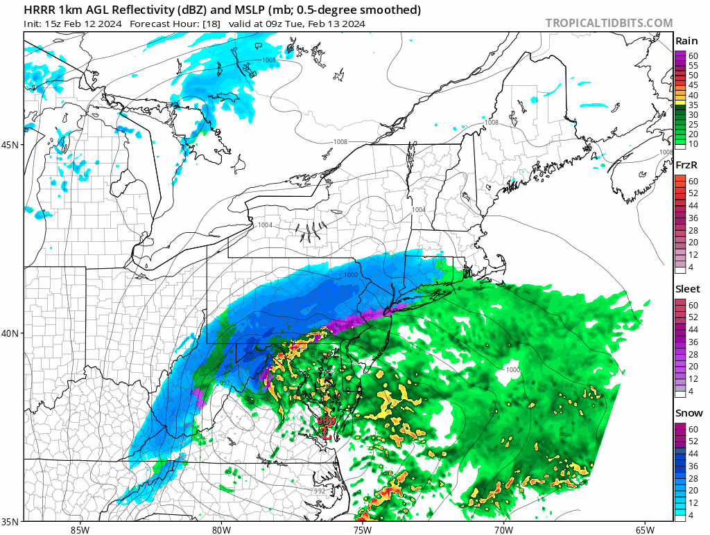
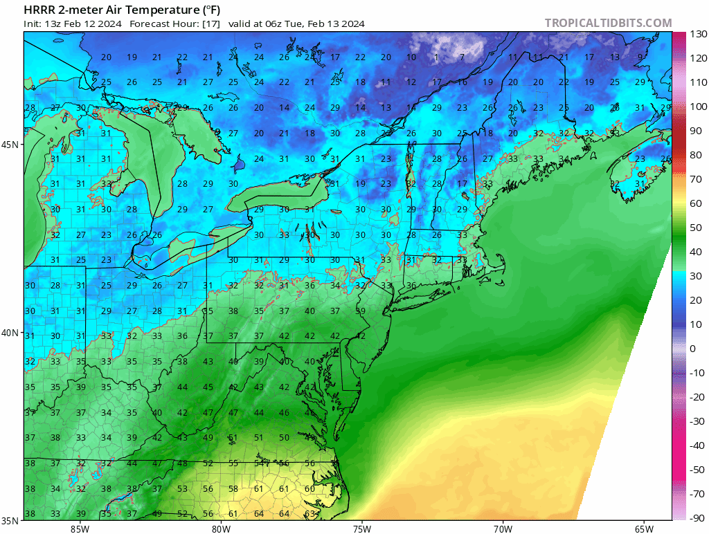
2/13 Significant/Major Winter Storm Discussion & Observations
in New York City Metro
Posted
The "walking to school uphill in 3 feet of snow" probably evolved over many decades, AND not necessarily occuring in the immediate NYC metro area. Also, no doubt, people from eastern PA and other outlying areas, moved into the area during the 50's and 60s, and brought tales of heavy snow with them.