

Dark Star
-
Posts
1,386 -
Joined
-
Last visited
Content Type
Profiles
Blogs
Forums
American Weather
Media Demo
Store
Gallery
Posts posted by Dark Star
-
-
15 minutes ago, qg_omega said:
No reason to not think every summer will be warmer than the summer before it going forward
That would be hard not to argue...
-
 1
1
-
-
10 hours ago, Rtd208 said:
Picked up 1.36” of rain for the day here.
0.84" here in the Tremley Point section of Linden, NJ.
-
9 hours ago, Allsnow said:
This will be the way it plays out
I wonder who is going to be right, StormWeather74 & All Snow or the Wx Channel Future Radar?
-
 1
1
-
-
1 hour ago, LibertyBell said:
The 90s were amazingly hot and we saw more 90s temps in that decade than any other before or since. I would extend this period from 1991-2002. 1991, 1993, 1995, 1999 and 2002 were all record setting hot summers with very high numbers of 90 degree days and several 100 degree days right to the coast.
The period 2010-2013 was similar but except for 2010, the heat wasn't as prolonged as it was in those earlier super hot summers.
Dunno, I know the ocean can be dangerous, but there is something to be said for self reliance. You have to be aware and respect the power. It would be a shame to close the beaches because there were not enough lifeguards. However, we live in a very litigious area...
-
1 hour ago, ForestHillWx said:
71/70…gross, wet blanket of an air mass. Hopefully we get some good storms later.
75/71 and the heat index is only 76? I cry Shenanigans!
-
10 hours ago, Dan76 said:
Willie Mays Passed
Another piece of me just died...
-
 2
2
-
-
15 hours ago, lee59 said:
Just add Newark and Central Park, divide by two and this can be the average summer high temperature.
")
Newark is usually the hot spot, but not usually too far off from where I live in central Union County NJ, maybe 1-2 degrees warmer, but the Central Park temps are not representative of anything.

-
3 minutes ago, bluewave said:
It’s not about cutting down trees or paving over everything. NYC is the only major station in a park or rural setting that placed the ASOS under trees in 1995. The New Brunswick station is a great example of how to place a weather station in a more suburban or rural setting. Notice how the trees are away from the thermometer and the equipment isn’t in the shade. NYC fundamentally changed how they measure temperature back in the 90s so it created a discontinuity in the long term climate record. I guarantee you if they placed the equipment on the great lawn instead the highs wouldn’t be that much different from Newark. Going by what NYC and Newark recorded with 90°days before the 90s, NYC would probably have 29 days reaching 90° each year vs 33 at Newark instead of the 17 of recent years. So the tree growth over the last 30 years has resulted in a reduction of around 12 days reaching 90° a year. You will also notice that the New Brunswick station even though there are trees and grass around have seen a steady increase in 90° days over the years.


So this proves that the NWS Central Park temperature measurements are not representing what was intended? Obvioulsy you can't "move" the location, but they better modify it soon. Why are they so stubborn?
-
1 hour ago, psv88 said:
Did you look at the max temp column? High daily temperatures mean the max temp, not the hourly average temp.
I did notice that, after I tripled checked the page. Thanks. I don't think I ever notice that column before. Maybe because I was never looking?
-
57 minutes ago, psv88 said:
NWS website showed a high of 92 in the hourly history chart. Not sure where you are looking.
The NWS hourly history chart.
-
1 hour ago, Rtd208 said:
The high temp yesterday at EWR was 92
My mistake. I know Weather Underground was reporting temps in the low 90's in Jersey, but the NWS hourly temps only indicated 90 degreess at Newark. I guess it didn't average out to 92 for the hour?
-
2 hours ago, JetsPens87 said:
Central Parks temp sensor is in the middle of a forest and should never be used for gauging a heat wave.
I have seen the endless threads about the Central Park weather station, placed under a canopy, as well as the pathetic snow measurements...
-
6 hours ago, Wxoutlooksblog said:
Looking at the GFS tonight I think there's a developing possibility that Central Park may not hit 90 degrees all week into the weekend. Yes it still may be a long shot, but on the latest GFS maps the high pressure is too far north and it does not really move south, it moves east and what replaces by the weekend is a backdoor cold front, a weak one at that, but enough to trigger showers thunderstorms and lots of clouds to keep temperatures down. We shall see about this.
WX/PT

I must rally be losing all the rest of my memory. I know Newark's temperatues are a "few" degrees warmer than NYC, but they are generally close. Yes, NYC is closer to the ocean, but if Newark is in a heatwave, NYC is almost always in a heat wave. Has something changed, or is it just that June can be an "unusual" month because the ocean temperatures are still cool, that this is an extremely specific sea breeze effect? Again, if NYC gets ocean cooling, it normally reaches Newark?
-
3
-
-
18 hours ago, SnoSki14 said:
As hot as it'll get here, the real record heat is further north.
It's crazy that this will be the last comfortable day until who knows when.
When nuclear winter begins...
-
1
-
-
4 minutes ago, Stormlover74 said:
And double rainbow

-
2
-
-
It almost seems that the 2-4 week forecasts are becoming more accurate lately? Then again, our below normal pattern still generated slightly above normal temperatures, and the average is based on the previous 20 years which is above normal?
-
13 hours ago, FPizz said:

Average, that seems pretty safe?
-
1
-
-
21 hours ago, Stormlover74 said:
Yeah barely an inch the next 2 weeks. Of course depending on storms could end up higher or lower than that by a good amount
Been watering for only 10 minutes in the morning for about 2 weeks. "Conventional Wisdom" would say to water less often but to make sure to water at least 1" every few days. Based on observations of lawns with sprinkler systems watering everyday for short periods, these seem to do the best. Grass always seems to like rain water vs. potable water. I'm assuming the chlorine is not appreciated by the grass.
-
1
-
-
1 hour ago, bluewave said:
There have been a few scenarios that we have been experiencing in recent years with these over the top warm ups. The first one is that heat builds from Mexico to the Western US and moves into Canada and the Northern Tier but never really gets here. This happens when the ridge is so strong to the north that it leaves a weakness underneath. This is where we get onshore flow here keeping the highs lower. Then the other is when this pattern is accompanied with enough height rises here that the warmth starts out in the West and travels into Canada and then southeast down to our area. Our traditional heatwaves from the past would start out in the Southern Plains and move across Chicago and the Great Lakes into our area a few days later.
In the winter, we had the Pacific Jet pumping warmer air almost directly into Canada, so at times, western and central Canada was not a source for cold air?
-
13 hours ago, 495weatherguy said:
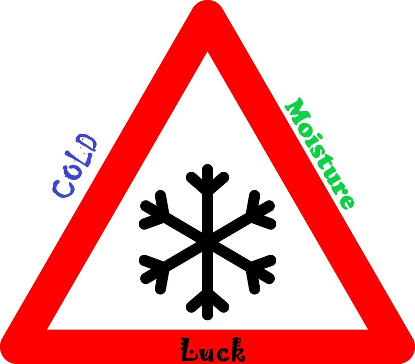
I agree. But one thought I always come back to is that it is really difficult to get real, prolonged winter weather around here. As someone who grew up in the largely snowless winters of the late 70’s and 80’s(save for a few storms)I am reminded of an explanation I heard from a meteorologist regarding cold and snow around here. Plainly put, it’s really difficult due to the maritime influence on our weather. I’m sure there are technical reasons which I do not know about or understand, but that’s it in a nutshell. Lots of factors have to fall into place. But we seem to have gotten away from the mindset after the very snowy early 2000’s. Seems to me that we had an incredible streak that was just not sustainable from a climate perspective. My .02 I know now is not the time to be discussing winter, but the mindset is the important thing to remember here. We have to be realistic in our expectations
Which is why I came up with the snow triangle for the NYC metro area...
-
1
-
-
14 minutes ago, Stormlover74 said:
There certainly are some who do that
Seems to be even more difficult today, despite all the technology.
-
1 hour ago, Stormlover74 said:
Looks that way
I stand corrected, already...
-
24 minutes ago, Stormlover74 said:
Upton went 90% pops this afternoon. We'll see. Added a slight chance of a shower tomorrow as well
Interesting, but I wonder for where. Looks like NYC and points south may miss most of the shower activity?
-
On 6/3/2024 at 10:05 PM, donsutherland1 said:
Speaking of flamingos, one has reached Cape Cod.
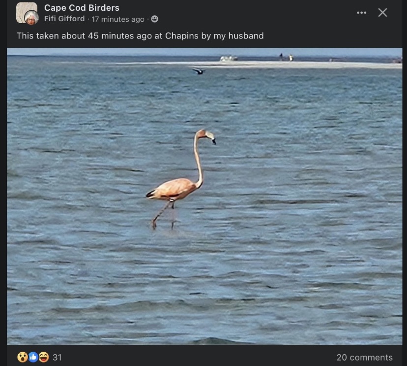
I guess it won't be pink for very long? I think their color is based on their diet?
-
 1
1
-


July 2024
in New York City Metro
Posted
Maybe because the heat index (real feel) is talked about too much? I would prefer less emphasis be put on "real feel" temps, even though there might be actual health risks involved. Too many people hear wind chill of 10 degrees, and think that is the actual temperature.