HKY_WX
-
Posts
3,237 -
Joined
-
Last visited
Content Type
Profiles
Blogs
Forums
American Weather
Media Demo
Store
Gallery
Everything posted by HKY_WX
-

The “I bring the mojo” Jan 30-Feb 1 potential winter storm
HKY_WX replied to lilj4425's topic in Southeastern States
Significant jump west at 5H. Let's hope we start to see some alignment among the ensembles.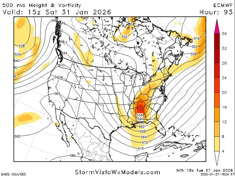
-
The “I bring the mojo” Jan 30-Feb 1 potential winter storm
HKY_WX replied to lilj4425's topic in Southeastern States
That's what she said. -
The “I bring the mojo” Jan 30-Feb 1 potential winter storm
HKY_WX replied to lilj4425's topic in Southeastern States
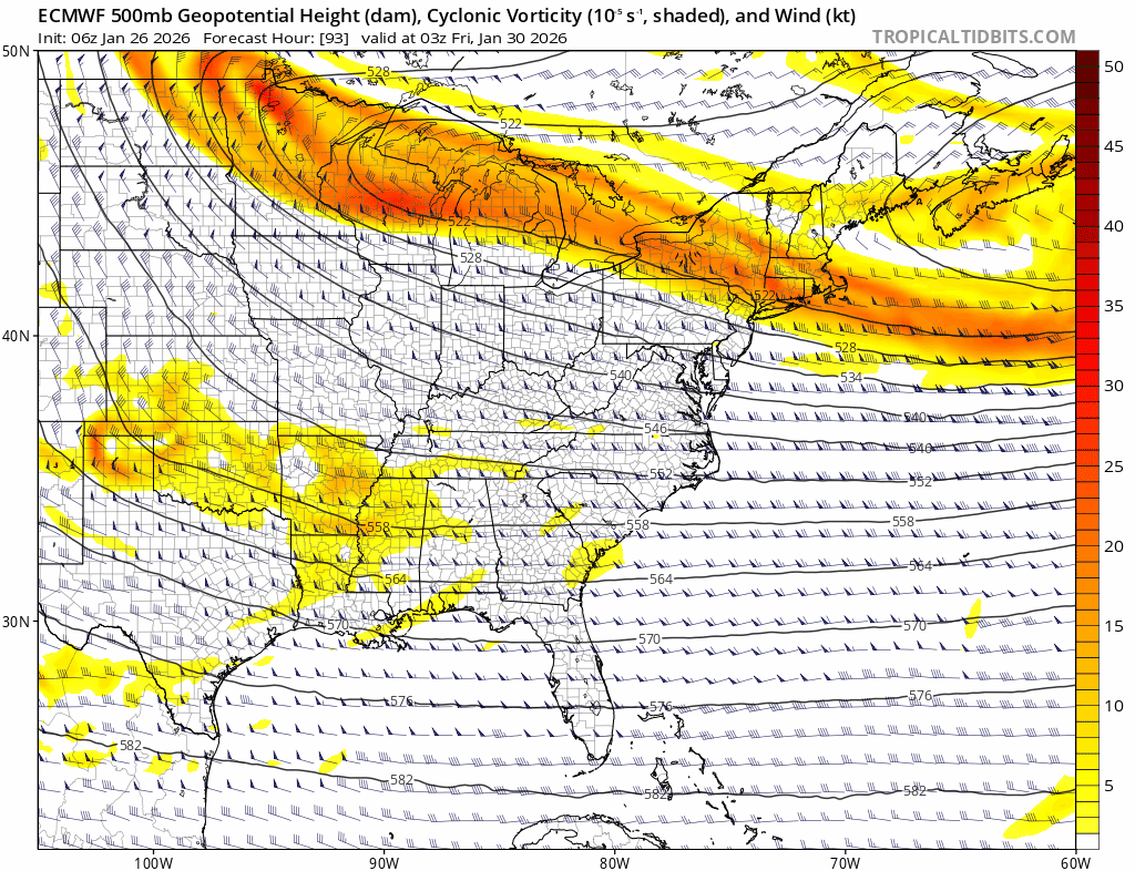
For those wanting to understand the synoptics of the pattern and why the GFS trended better, it's mainly related to the upper low over the northern Atlantic. In the older days, this feature was/is referred to as the New Foundland low or "50/50" low, which forms near the 50/50 lat/lon area. It's a prevalent feature during -AO patterns which features lower heights over the CONUS and northern Atlantic, while higher heights build into the northern latitudes. This upper low acts as a way to slow down the pattern and induce additional cutoff lows upstream (in this case it would be our storm). The problem is if it's too strong it will suppress or shear out any attempts at this feature. This is a common model fault especially during these types of extreme -AO patterns. It's also a reason why commonly see these SECS systems trend NW/more amped as we draw closer. It has screwed us many times in the south. It could benefit us in this case. We want to see this 50/50 low continue to trend quicker and exit faster into the Atlantic. This allows the heights over the east coast to rise and give us a better chance at a cutoff with at least a netural tilt, which will throw back Atlantic moisture.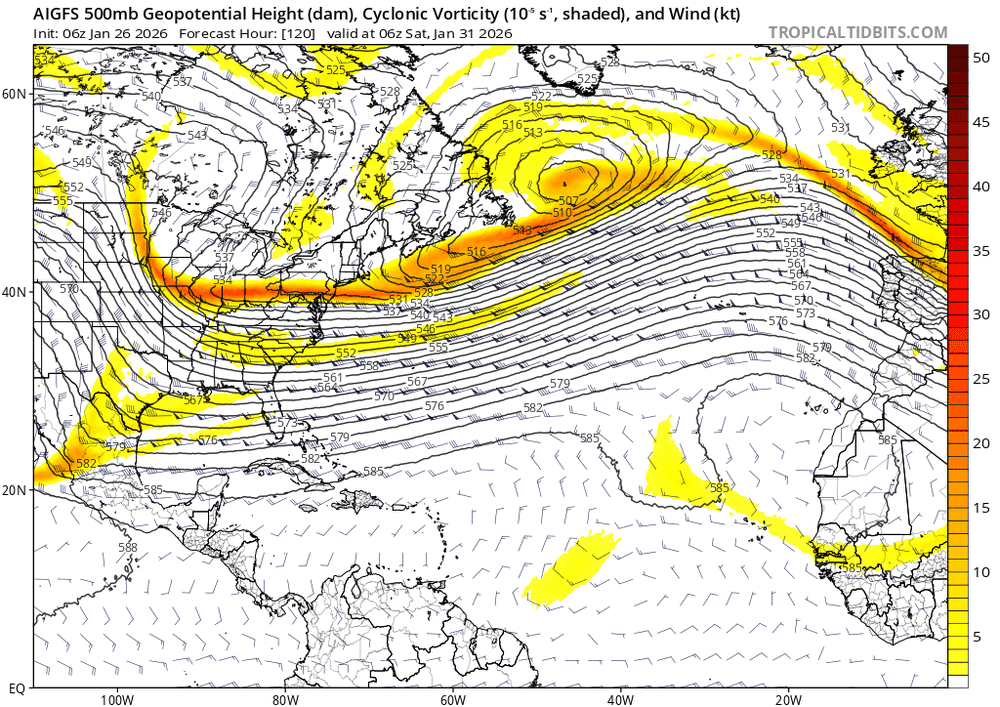
-
The “I bring the mojo” Jan 30-Feb 1 potential winter storm
HKY_WX replied to lilj4425's topic in Southeastern States
6z Euro AI is west, OP is east. -
The “I bring the mojo” Jan 30-Feb 1 potential winter storm
HKY_WX replied to lilj4425's topic in Southeastern States
I wouldn't crown it yet. The sample size is not very large. -
The “I bring the mojo” Jan 30-Feb 1 potential winter storm
HKY_WX replied to lilj4425's topic in Southeastern States
This solution is pretty incredible. Its literally a piece of the PV lobe breaking off and phasing with a piece of energy in the STJ. The heights would be anomalously low for our area if it were to actually occur. Its extremely rare and also why we should understand the high bust potential of this. Let's hope it works out for a change. -
The “I bring the mojo” Jan 30-Feb 1 potential winter storm
HKY_WX replied to lilj4425's topic in Southeastern States
Best case scenario weenie run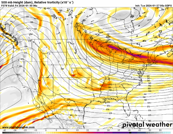
-
The “I bring the mojo” Jan 30-Feb 1 potential winter storm
HKY_WX replied to lilj4425's topic in Southeastern States

-
The “I bring the mojo” Jan 30-Feb 1 potential winter storm
HKY_WX replied to lilj4425's topic in Southeastern States
ICON EPS . Love the location of the HP. Generally a very good spot for SECS Miller A's. -
The “I bring the mojo” Jan 30-Feb 1 potential winter storm
HKY_WX replied to lilj4425's topic in Southeastern States
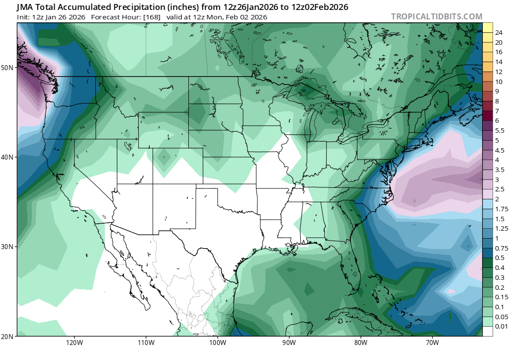
The JMA is in our corner (aka the standard bearer).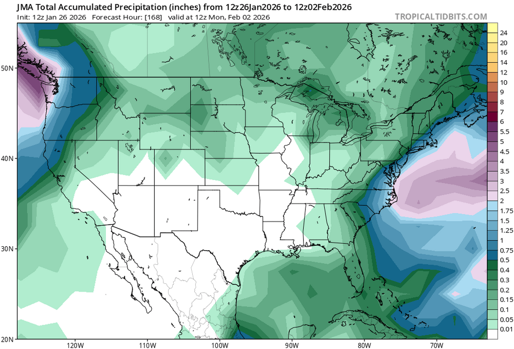
-
The “I bring the mojo” Jan 30-Feb 1 potential winter storm
HKY_WX replied to lilj4425's topic in Southeastern States
Dec 24-26 2010 is very similar but again nothing is perfect as we learned last week. Each setup is unique in its own way. The timing on this one has to be very good. Definitely a boom/bust scenario. https://www.meteo.psu.edu/ewall/NARR/2010/us1225.php -
The “I bring the mojo” Jan 30-Feb 1 potential winter storm
HKY_WX replied to lilj4425's topic in Southeastern States
Still really close aloft. -
The “I bring the mojo” Jan 30-Feb 1 potential winter storm
HKY_WX replied to lilj4425's topic in Southeastern States
None of the models were great 5 days out. The Euro AI was always further north and had a dry slot in eastern NC once we got inside of 48 hours.. It was way better than the GFS or ICON. The reason I know this is I looked at waaay too many model runs the last 3 days. -
The “I bring the mojo” Jan 30-Feb 1 potential winter storm
HKY_WX replied to lilj4425's topic in Southeastern States
I only care what the Euro and Euro AI say. They led the charge with this previous one. Euro AI did especially well. -
The “I bring the mojo” Jan 30-Feb 1 potential winter storm
HKY_WX replied to lilj4425's topic in Southeastern States
Players on the field here are much simpler. Polar jet wave diving south and phasing with STJ wave coming into the west coast this week. The icestorm pretty much locked in IMO about 48 hours out once all the waves were close to the US. So I would wait until Wednesday before getting too excited. In the meantime, enjoy your hits of model crack 4 times per day. Scenarios: BOOM: This setup works out like the Christmas storm 2009 and we have a perfect phase BUST: Nothing nada zilch. Cloudy day on Saturday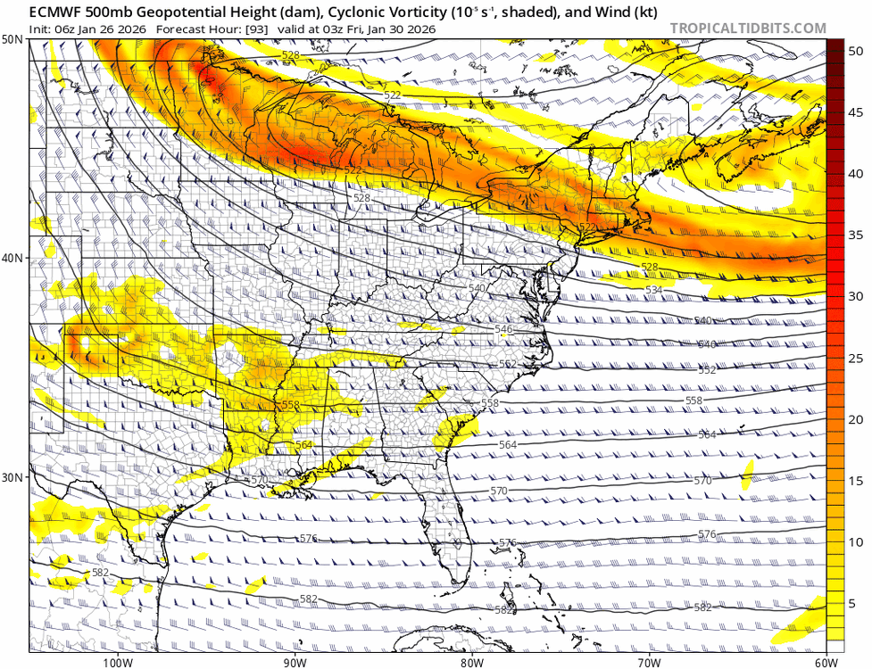
-
The “I bring the mojo” Jan 30-Feb 1 potential winter storm
HKY_WX replied to lilj4425's topic in Southeastern States
Trend gif below for the euro. Good trends but again, let's hope it doesnt go too much in this direction or it will trend too warm for eastern NC. Will have to watch it. Classic polar jet wave diving down in behind the departing cutoff over new England. Great setup for a snowstorm (especially over the mid atlantic/new england). This is more of a snow or rain setup.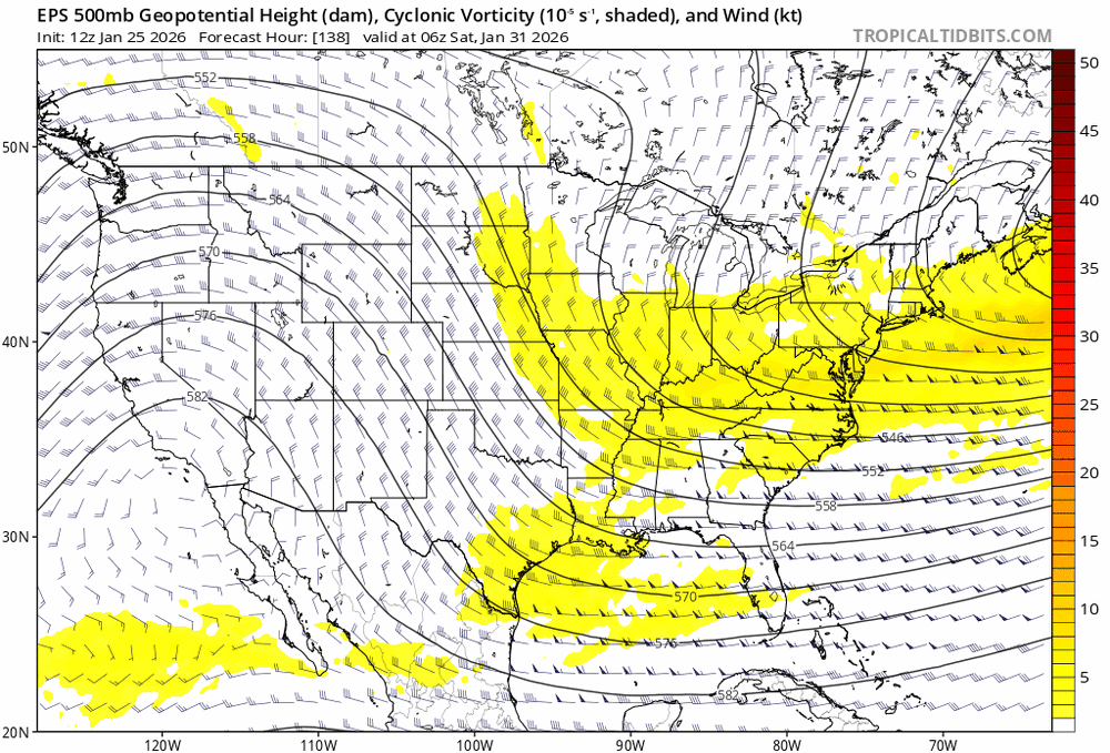
-
This hobby is comparable to a Crack addict
-
Southern Crippler - Get well soon Jimbo Storm Obs
HKY_WX replied to BooneWX's topic in Southeastern States
Heavy sleet here. Still 21 in Franklinton. Def a model bust on the cold eroding today which is pretty normal these mega CAD situations. The mega cold/low dewpoints really screwed NC/SC qpf wise since the dynamics were a bit northwest of us. Its amazing how each individual system is unique in different ways. -
Southern Crippler - Get well soon Jimbo Storm Obs
HKY_WX replied to BooneWX's topic in Southeastern States
Light freezing rain here west of Franklinton since about 9pm. 17 degrees. Has mixed back to sleet a few times. Ground is white and trees are glazed already. -
Yeah, QPF is not going to be an issue with this system in NC. The only area that will get dry slotted is the coastline counties. Most of the state will get 1.5 to 2inches of QPF easily.
-
Im tired bro. This is a fun but exhausting hobby.
-
The HRRR is the one we want to show it. The RAP is pretty much an outdated PO$hit.
-
HRRR lines up pretty well the GFS on a possible quick 1inch or 2 in the northern half of NC b/f the changeover.
-
There will be a dry slot but I think it will stay mostly along the counties that border the SC/NC coast, maybe 2 counties inland. This happens a lot with systems that skirt along the coastline. The dry slot with winter SLP's tends to follow closely along/ahead of the SLP track.
-
I don't see much other than noise on the models tonight. They have started to lock in on this one IMO. I'm a big analog guy, and as we all know the weather/climate tends to run in patterns. As stated a few times, this a very similiar setup to dec 2002 in a lot of ways. Not a perfect comparison, specifically b/c it was in early December, however it was one of the better ones I could find. The GFS is also reminding me a bit of 2/2/96 icestorm with brief changeover to snow at the end. That system was probably the worst icestorm in recent history for the foothills and also similar to this one with the STJ wave diving so deep into Mexico, along with some northern stream phasing and bitter cold following it. This will be a very memorable storm, so buckle up.