psuhoffman
-
Posts
26,456 -
Joined
-
Last visited
Content Type
Profiles
Blogs
Forums
American Weather
Media Demo
Store
Gallery
Everything posted by psuhoffman
-
He thinks we are completely fooked. He just wont say that until March. But if you read between the lines... i was morbidly curious, and hopes to see one of his epic melt downs, so I just skimmed through his blog posts from the last 24 hours He admits he didn’t see the mjo phase 4/5 coming. He says snow next week will be north of Mason Dixon. He says big warmup eastern ridge coming. He admits the warm water near maritime continent (I mentioned the other day) is a big issue. He says cold might press late January and early February before mjo goes back into warm phases but without cold phase mjo help (he doesn’t expect that given the sst look there) the cold won’t overwhelm but press over the SE ridge. he says that will help New England. Then he even leaves an escape hatch that “what could kill the whole winter with that warm water north of Australia is if the mjo cycles right back into warm phases like the euro shows”. Basically he thinks are doomed he just won’t ever say that because he needs people to keep paying attention every day. He will talk about who isn’t screwed in times like these. But if you know what it means you can read between the lines easily.
-
Thanks Wes. I found similar results with my 5”+ BWI snowfall study. It seems if we are in a -NAM state the PNA becomes less crucial. But if the AO is + we need either a perfect EPO ridge or PNA ridge to have much of a chance. I found the NAO numerical index to be misleading sometimes. Often a snow event followed the NAO blocking. If you look at the time of the event the NAO was neutral or positive but several days prior had been a nice blocking episode. Also some west based blocking (great for our purposes but not a canonical NAO) or Hudson Bay blocks were hidden in the numerical index if the east NAO domain had a trough or there was a ridge near the Azores.
-
It was actually a trifecta of busts over a month that got me about as bent out of shape as I’ve ever been over snow. I was living in South Jersey at the time. We had several straight really god awful snowless winter with nothing more than minor events and numerous bad busts (like feb 89) in the mix. I don’t know what happened/went wrong and I was too young to follow models yet but I remember each vividly. The first was a west to east system that was forecasted to be 4-8” then some sleet. It snowed for 20 mins before going to sleet then freezing rain. Got about an inch of sleet and ice. The second was a hybrid miller A/B that was supposed to be 6-10” then the day of they lowered it to 4-8 then 3-6. Should have known then. That evening we got about 1” of snow. Woke up the next morning to bare ground and driving rain that lasted all day. Ended up really warm too. Like 50 at least. They really blew that one. I think it didn’t transfer soon enough and ended up more a cutter than expected Last one was another west to east storm predicted to be 4-8” and we got about an hour of heavy snow that went to rain. Snow ended up NW of predicted. The last one was towards the end of winter and I was wrecked emotionally. ETA: I do think there was one good snow in 90 or 91 maybe and I missed it because we went on a family vacation to Maui for a week. Lol
-
Euro phases and has a huge cutter. Take the average. Lol
-
Feb 24 1989 I think. Not sure why it busted. But it didn’t bust by that much it simply had a sharp back edge. Atlantic City had 19”. Cape May 24”. But where I was 35 miles NW of there nothing. Philly was always on the back edge because I remember the night before the forecast was 1-3 NW of the city. 4-8 in Philly. 8-14 SE and 12-18 at the shore. The back edge ended up with a tighter gradient and maybe 20-30 miles east of expected.
-
There was a Kara block but that storm wasn’t a function of a bootleg pattern. It was classic. It also had a perfect west based -NAO, ridging near Hudson Bay, monster 50/50, central pac trough with SW ridge alignment. It looked like a mirror image of the HECS h5 composite. No wonder guidance saw it coming a mile away. This was the look for the whole core of that winter. In the end we probably ended up with about what we could expect but it all came in one massive dump. We easily could/should have had multiple snows from a 5 week pattern like this mid winter. We wasted a perfect track coastal on cold rain before the big storm because of the torched air mess left begins by the epic fail December. Then a storm before the blizzard and one after got suppressed. Another perfect track storm in early Feb was a few degrees too warm. I managed 8” of really wet snow up here while 95 was a non accumulating mix at 36 degrees. Finally a 6-10” storm missed us just to the south before the blocking relaxed some. Can’t complain since we got an epic HECS but we should have had more hits from a 5 week epic pattern like that. Not saying more HECS storms but more than one decent snow. It honestly was about as good a pattern as late Jan early Feb 2010 but with a crappier N American airmass heading into it. That really screwed us from a similar outcome.
-
What Bob said...also the baroclinic zone is wrecked by the wave out in front.
-
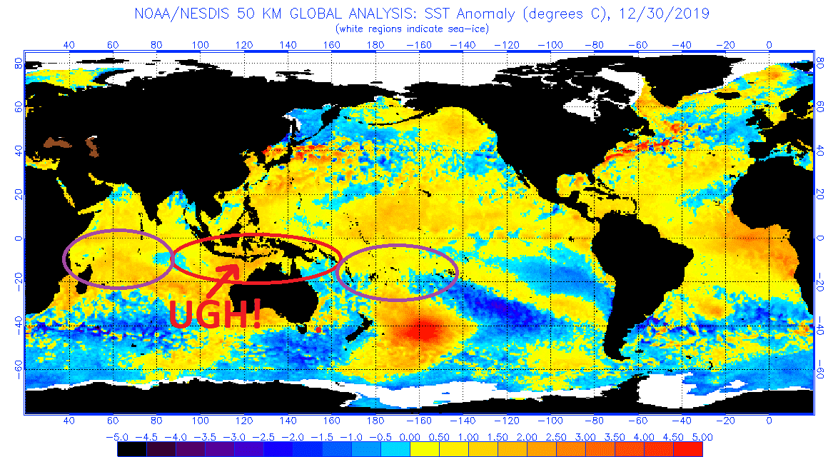
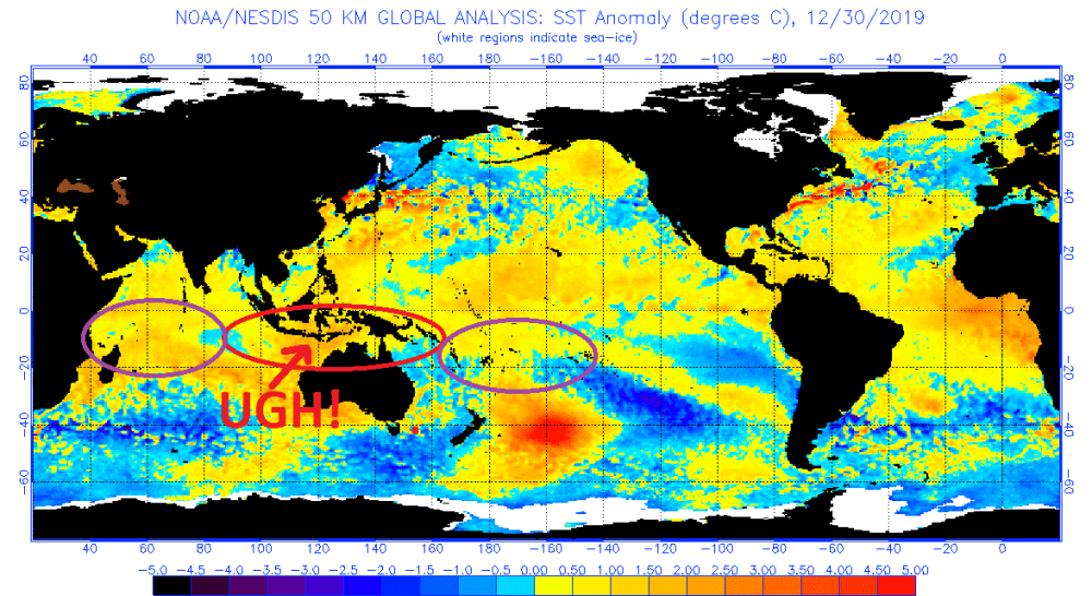
Some thoughts on the MJO and 2 possible escape hatch options to get out of this mess I have always seen the MJO as more of a predictor of warm than cold. It correlates much higher to warmth when it is in warm phases than cold in the cold ones. IT does a better job forecasting huge eastern ridges...sometimes we go through cold phases without much impact though. Don't get me wrong we are better in cold than warm...but frankly I just want to see it keep its hands out of the maritime continent warm phases. We can do just fine when other factors are in our favor with a weak inconsequential mjo wave. On the other hand when other things are bad and we are patiently waiting on the mjo to save us usually it just races through the warm phases without doing us much good. With that said...there have been significant changes to the mjo sst areas and not for the better. THis is why seasonal forecasts are maddening. This was the SST in November and why I was optimistic. The numbers correspond to the area of convection for each phase and the red is the warm phases and the purple circles are the cold. You can clearly see the sst was aligned perfectly to suppress convection in the warm phases and foster convection in the cold phases. The cold pool in phases 3/4 was perfect to kill the waves heading into warm and the warmth in 7 was good to spark waves heading into 8/1. And for November into December we got that effect and we generally had an ok pattern. Some wanted the IOD effect to come off so the standing wave in 2 would cut off allowing the wave to progress into 8/1 near the dateline which is technically better for our snow chances, especially early in the season. But what happened instead was not good. look what has happened around the maritime continent... this is the current look and supports the forecast by guidance of the mjo into a strong warm phase signal. That is also why I am hesitant to toss the guidance that shows a strong standing wave stuck in warm phases for a very long time. There is enough warm water still in the cold phases that its not hopeless but the trend is not good...warming where we don't want it, and cooling where we want warming. So long as we see the MJO strongly in phases 5/6 don't buy anything that shows improvement. But assuming at some point the mjo relaxes or moves out of the eastern torch phases there are 2 ways to adjust this pattern in a realistic way and get to a better place. Assuming the guidance isn't completely out to lunch and we do get a strong pac ridge...there are 2 realistic errors (not needing so much error to be crazy to expect) to the ridge alignment for January which would predict a better outcome going into Feb. Neither gets us to good right away, we would probably still suffer until Feb...but these adjustments to the Jan mean look would predict a better outcome come Feb. This is why the current look is so bad. Probably the worst look there is for snow here. That ridge location is just right to prevent the TPV from retrograding west off the pole, but also perfect to dig the trough in the west and pump the eastern ridge...and with the TPV up there that ridge cant build up into the high latitudes. It sets up a mess in every way. Option 1 or "error option 1" would be if that ridge ends up slightly west of where its forecasted. That look would portend a more likely better outcome in Feb. It would allow the TPV to slide west into AK...while not idea that would allow the eastern ridge to build up into the NAO domain which would eventually favor the wester trough to cut under. It would take a while but it gets us to a better look in Feb. These are some examples of snows from that progression and the end result. Option 2 is if that ridge builds slightly east or northeast of where its progged. THat would look like this... That could allow the Scandinavian ridge to pressure over the top and drop the TPV into Quebec which can lead to a better look...these are some snows from that look Both also require an improvement in the NAM state. But there is some symbiosis going on there because the central pac ridge also correlates strongly with a positive NAM state. But either of those adjustments to the mean ridge position for January would eliminate those god awful analogs I posted last night and bring in some better outcome possibilities for February.
-
I am hopeful but I am also weary of some of the longer term guidance (EPS Weeklies) that basically create a standing wave in phase 5/6 for a LONG time. The current SST might support that idea. About to make a post on that.
-
yup agree 100%...hence the "grasping at straws" part. And if I was in your boat I probably would be rooting like crazy just for that 1" scenario. Hell...if all else fails I will still be rooting for the 1" over nothing. But up here I have seen about four 1-2" snows so far...but nothing of consequence more than that so I guess I am looking for a bit more "meat on the bone" so to speak here. But I think we are seeing the same thing wrt to the potential.
-
we need a bit more amplification in the PNA ridge to help the trough dig a bit more in the east if we want to pull of anything of consequence. Like you said we could root for a weak sheared out wave to drop another 1" type deal with the current depiction. The way to turn this into something with a bit more upside (and it wouldnt take an unrealistic adjustment at this range) would be a bit more amplified PNA ridge to help that trough dig south a bit more...then we "could" get a slightly more amped wave without it tracking north of us. I am just grasping at straws here I know...but its all we got.
-
As CAPE said this is a great look for the west. Cold and snowy. Could be too cold for the northern ski resorts but places like Colorado when it’s sunny isn’t that cold. I skied Stramboat when it was -25 with the sun out and it actually felt ok. During a storm with wind at -25 though...forget it. But Alta in Utah is already up near 200” on the year with 20-30” expected in the next 72 hours. Yes they get a lot of snow but that’s still a great start with their snowiest months yet to come. I know Revelstoke was doing pretty good also last time I checked. I’m heading out there either the last weekend in January or the first 2 weekends of Feb and I’m salivating already. With this pattern they should be found great with all backcountry chutes and bowls open. ETA: you have to get pretty far north in the east for that to be a good look. Depending on how much the boundary can press and where the TpV near Greenland is it CAN be a good pattern for the mountains in northern New England. Northern NY Vermont and Maine. But if the TPV isn’t far enough south this can be a rain pattern even up there. I was up around Quebec City in the winter of 2008 (comp year to this coming pattern) and it rained all the way to where I was near Le Massif at 3000 feet elevation 40 miles north of Quebec City in mid winter. That’s about as rare a feat for them as a warning snow is for us.
-
It’s a long shot but get that Scandinavia ridge a little west (needs to retrograde to where it’s poking into Iceland) and working in conjunction with a monster 50/50 and it can work. There was one snowstorm in the dataset of central pac ridge snows that looked like that. Most had a west based NAO block though. But that kind of Scand ridge can be a precursor to NAO blocking. As you said it’s all we got. It’s really our only way out of this mess.
-
I added this profile in the snow climo thread but I think it belongs here too. This is the composite of all PNA Ridge induced snowfalls with a +EPO/+AO/+NAO. The look next week is "close" enough to this on the ensembles right now that it isn't completely out of the realm of possibility we sneak an event in before the coming end of winter forever pattern. 6 storms over 72 years inst exactly a high probability...but its something.
-
PNA RIDGE Snowfalls +EPO/+PNA/+AO/+NAO snowfalls 6 I only got one more profile done today but figured I would add a PNA ridge pattern snow composite since that seems to be what we are working with for our only real shot at snowfall next week. These were the 6 storms where the only thing really working for us was an ideally placed PNA ridge. This composite is centered for the day the storm was starting. You can see the ideal placement for a PNA ridge there can sometimes overcome what is otherwise a pretty craptastic pattern there. I did notice the ridge axis is slightly west of what is common for snowstorms when we have some blocking. THat is likely because without any NAO blocking the pattern is more progressive and we want the PNA ridge slightly west of where we normally see it in most snow events. It's not that far off...normally it would be closer to Boise then Tahoe but still its noticeable. I guess with the coming "threat" if we want to call it that...if we see a ridge looking like that out west at the perfect time it COULD be a legit threat.

-
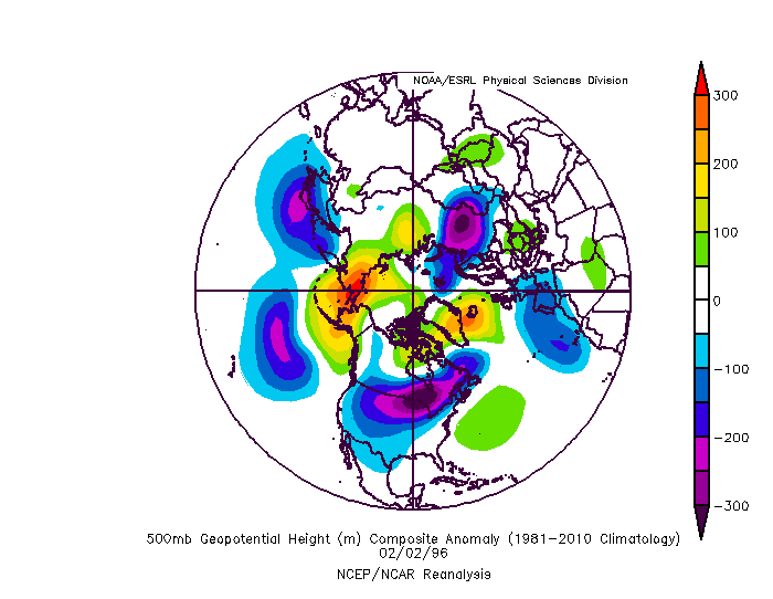
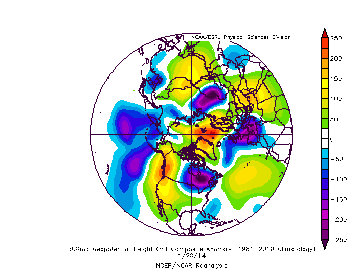
These are some examples of warning events with a ridge bridge
-
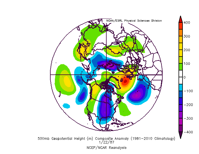
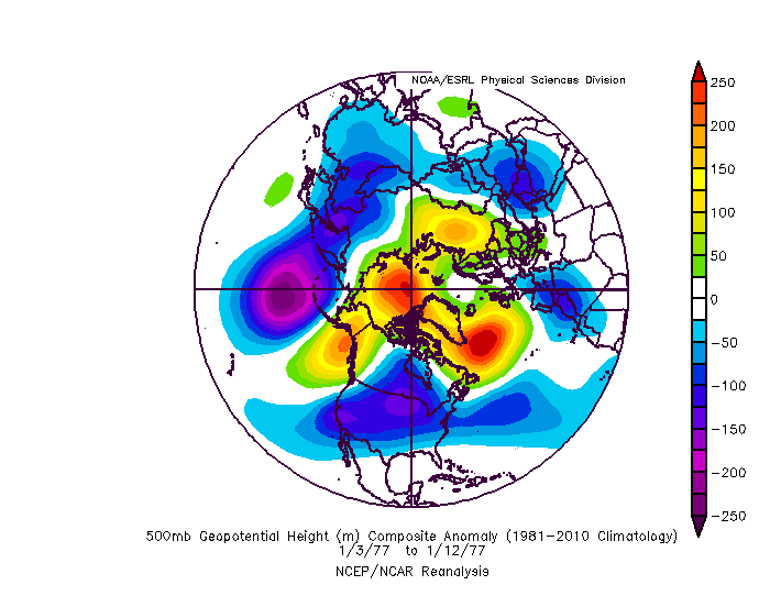
I remember the exact conversation you are talking about. It is possible to get a ridge across the entirety of the EPO/AO/NAO domains...and yes that is commonly called a ridge bridge...and when it happens it is extremely good for our snow chances. But it is very rare. So the fact that there are not more snow events with both a -NAO and -EPO is simply because that combination is less common not that it isnt a good pattern. But the reason our absolute biggest storms are usually associated with a +EPO is mostly because they are also associated with the most anomalous west based NAO blocks. Typically a block that strong cut off over greenland makes it even harder to have a strong ridge in the EPO domain. Frankly if we did it would probably be too much of a good thing and might flood the CONUS with so much cold it would just be a uber cold dry look. Think January 1977 \ Brutal cold but not much snow.
-
Holy crap, I thought I was the doom and gloom one.... yup, I wish the powers that be would settle on one common label for a lot of these things to stop the confusion.
-
NAM is the Northern Hemisphere Annular Mode, or what is more commonly called the Arctic Oscillation or AO.
-
That wasn't the one that brought me to tears...that storm happened a little earlier in that god awful dumpster fire period but I remember it well. It certainly contributed to my buildup of misery. I was actually foretasted to get 8-14" being about 15 miles southeast of Philly and ended up with NOTHING. I went to bed and the evening news said 8-14" southeast of Philly, 12-18" at the shore. I knew something was wrong when I woke up expecting a few inches already and the sun was out and the wind was blowing. I knew before I even turned on the news it was over. Was a CRAZY sharp back edge...Atlantic City only about 35 miles southeast of me got 18". I saw the dark clouds passing by to my east all day.
-
Actually there was a 4 year stretch from 1949-1952 also. But...what if this is year one of a 3/4 year stretch....????
-
I actually remember being in tears in 1992 at the end of that stretch (living in south Jersey at the time) after we were finally supposed to get a legit snowstorm (it was predicted to be 4-8") and it ended up 1" before turning to rain. I think it was very late in that season and it had been 3 years without a decent snowfall including a few other busts where 3-6 or 4-8" forecasts the day of a storm turned into very little or nothing...and I actually cried a little bit. It was awful.
-
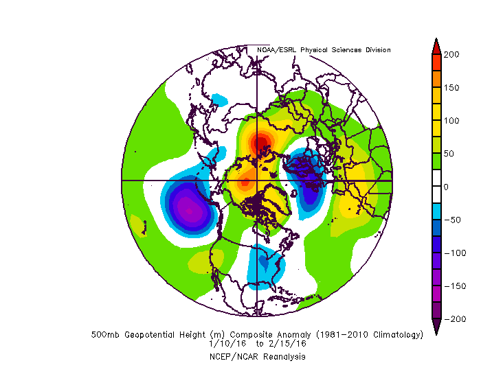
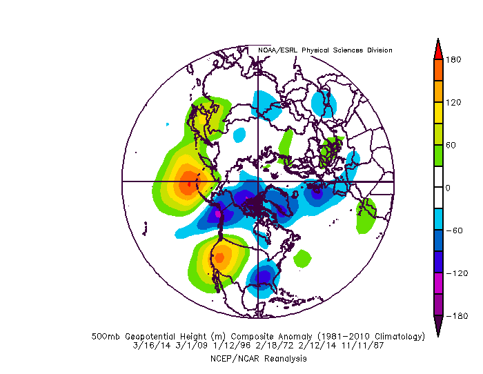
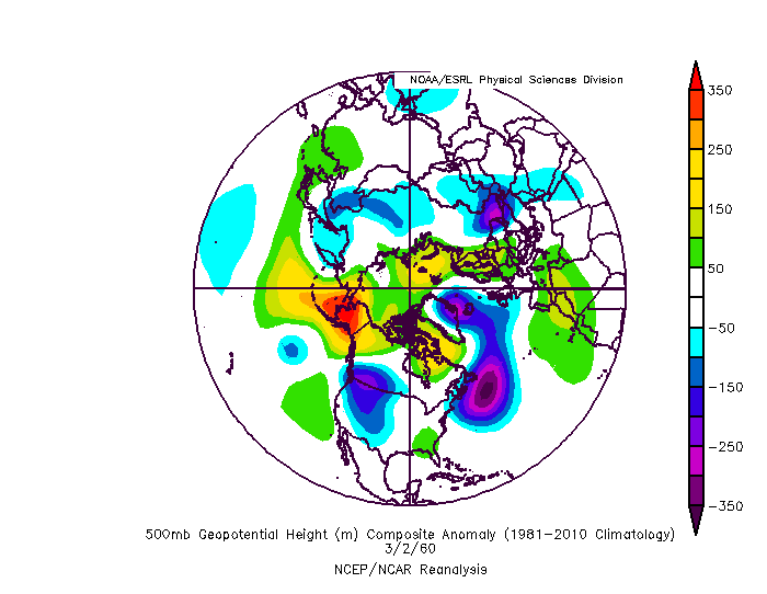
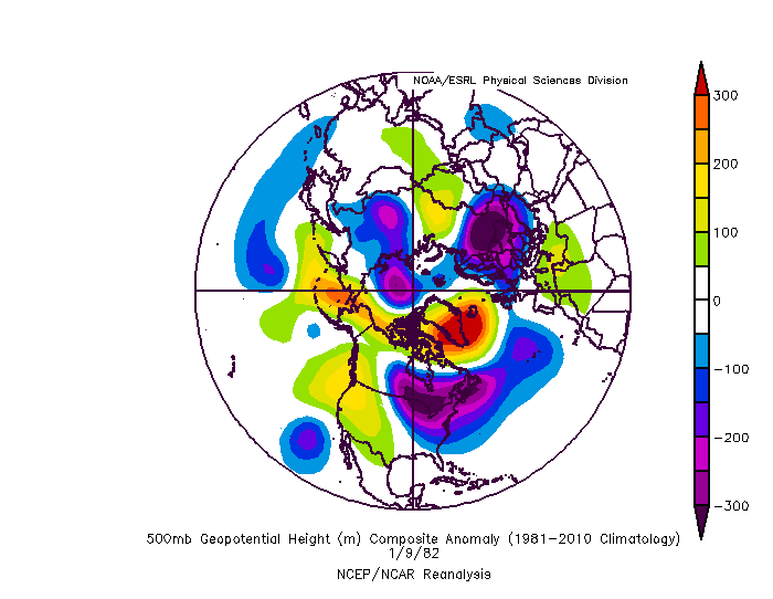
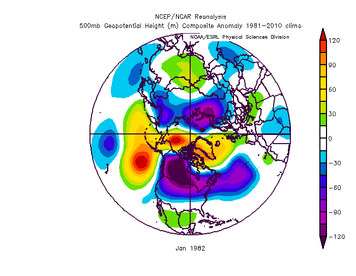
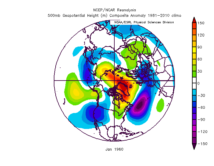
As a follow up to that last post... the reason my mood shifted suddenly about a week or so ago was due to the sudden flip of the NAM state. See back when I predicted a decent season I was relying on a similar Pacific to last year but with more high latitude blocking help. 1982 was one of my top analogs and so I was kind of expecting something like this... 1960 was also very high on the analog list 1960 took until later in winter to get good but in both cases what made it work was the HL blocking overcoming that pacific ridge. That pac look isnt the end of the world if you have AO/NAO blocking. That was what I was counting on. I guess it was really foolish to go against the long term +AO/NAO cycle but imo the north pac SST, atlantic SST, QBO phase, solar, and enso (weak warm following a nino) all argued for blocking this year. And through from November until a week ago...everything looked on track. Maybe not for the 1982 analog...I was starting to think we would have to wait until a little later in winter... but the 1960 look kind of matched what we were seeing 2 weeks ago with persistent Atlantic help being muted by the PAC. That pattern tends to get better later in winter. But the sudden reversal of the NAM state to a 2+ std dev positive really tossed that out the window. When the NAM state goes strongly positive this time of year it usually is a persistent issue. It sometimes flips but usually not until very late like 2018. Sometimes there is a fluke like 2006 where the NAM flips after being strongly + this time of year so there is always hope. But the fact is both a strong pac ridge and a strongly positive AO are both persistent features and when combined are a horrible pattern. That combination has lead to most of our epic fail dumpster fire winters. Just wanted to explain my thought process. I am not reacting emotionally to one model run. I am simply looking at the preponderance of evidence we are seeing...and I know historically that is the absolute worst pattern we could possibly see right now wrt our snow chances this winter. But there was that 1 year out of 15. And there were some other years "somewhat" similar that flipped better. If the guidance is off and that ridge ends up further northeast it throws all this doom and gloom out the window. Or if the NAO flips all bets are off.
-
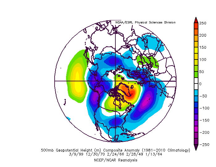
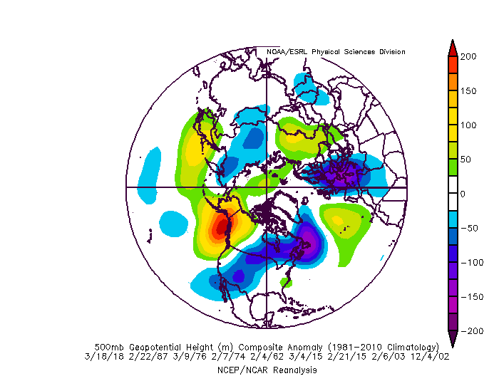
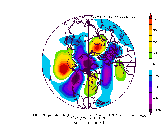
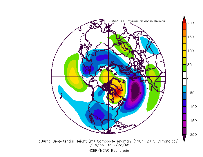
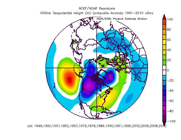
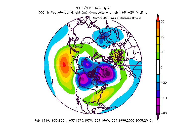
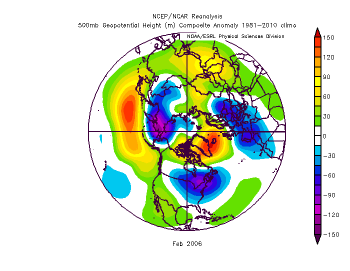
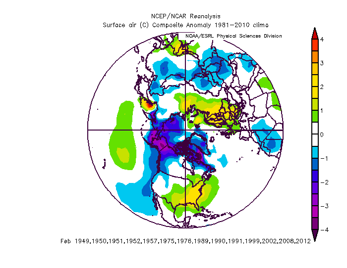
Now that I am home with the data in front of me...I will answer this...but its gonna hurt. First let me start with some hope...there were some similar patterns early in winter that flipped. The best 3 examples of that are 1965/66, 1999/2000 and 2004/5. This is the 1966 example. It went from this to this and a pretty epic period in late January and then another big storm in February. However...all 3 of those examples the pacific ridge pattern set in early in December and was already breaking down in the first half of January. This time the pattern is really just locking in during the first part of January. Big difference. In those 3 examples the pattern lasted a good month and then flipped. But a pattern setting in December with the jet still going through seasonal fluctuation is much different than one setting in January when the wavelengths are broad and the jet takes on its dominant winter phase. But I don't have all the answers...maybe those 3 should be used as hope that things could flip quick...although even in those examples quick wouldn't happen until February given the length of those patterns and that the same pattern is setting in a month later this year. If you want to sleep tonight I suggest you stop reading right now and disregard everything else I have to say because the rest of this is going to give you nightmares. Still reading.... you must really want punishment Wow you really hate yourself.... ok I warned you...you asked for it, don't blame me I am NOT paying for the therapy. Ok the reality those are NOT the real comps to this current situation. There are 15 similar January months to what the guidance is projecting for the first half of January. Assuming we do not get some kind of crazy fast shift...and nothing is hinting at that...it is highly likely January will feature a strong central PAC ridge and a +NAM state. 15 previous Januarys fit that. This is the composite of those years I think we can all agree that looks familiar...and is a good match to the current projections. Here are the facts you asked for...and I warned you, you are not going to like it. These are the Februarys that followed EVERY single one of those years was below average snowfall at BWI. Only one wasnt below avg at DCA. In all 15 of those years we only had one warning level snowfall in February and that was 2006. This was the patern that February. It took a complete reversal of the NAM state and great blocking to get the only good February we had following similar Januarys. I know some don't consider that month good because it was one "fluke" storm and then warmed up...but IMO we were unlucky not to get more storms that month. I don't see that storm as a fluke, I see it as a fluke that we only got that storm honestly. But whatever... IF you subtract that one year from the 15 February looks like this... And there were no warning level snowfalls and the avg february snowfall in DC those 14 years was 1.4". And this is the February temps for those months Bottom line... if the long range guidance is correct and what they are advertising day 10+ actually is reality... pray to god we get the 1 in 15 year miracle flip to a raging -NAO because otherwise we are toast and we are looking at a year like 1950, 1989, 2002, 2008, 2012... Maybe the CFS is right and the pac ridge ends up much further east than all other guidance and the MJO would indicate it will. Hug that and pray.... and don't blame me, I just put together the data...I am not happy about it and I didn't make it be and I am praying the guidance is wrong.
-
That look actually isn't too far from a workable one. As is that would be mostly a cold dry look after the wet look the first week which I suspect is from a cutter to usher in the pattern. BUT...get the trough to hang back into the SW a bit more to create a positively tilted trough with just enough SE ridge and it becomes a good pattern for progressive waves. I would take my chances with that look. Its a stones throw from a workable look unlike what the Euro weeklies suggests with is pretty much a no hope shut out the lights for the entire season look. However...I am about to drop what is going to be the least popular post in americanwx history.