

psuhoffman
-
Posts
27,419 -
Joined
-
Last visited
Content Type
Profiles
Blogs
Forums
American Weather
Media Demo
Store
Gallery
Everything posted by psuhoffman
-
The best part up here is how well we hold snow. This little high elevation area northeast of Westminster stays cold. I’m regularly 5 degrees colder than Westminster. Often I like to drive around the area after a snow and it’s amazing how much more is on the ground a few days after here v Westminster or other parts of the county.
-
Good discussion. Also, that band hit too late after the column was wrecked. Look at the radar from 4am-8am. The heavy precip was all Winchester to Carroll County. That was the window for good snow along 95 and they were stuck in a dryslot. By 9am when that band did finally get there the warm layer had taken over. Heavy precip earlier could also have helped mix out that layer and held it at bay longer. But your point about bad luck is true. I think it’s some of both.
-
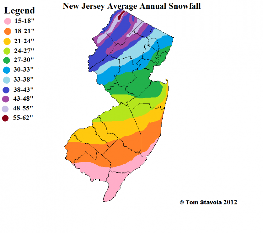
Good to see you back. I dunno about the Monmouth comp. There is some degree of bad luck here. Not denying that. So your point isn’t totally wrong. But able averages across that country range from about 24-28” in most places. I grew up in NJ. I would choose that area over DC or Balt for snow 9/10 times. DCs snow climo is similar to along the pink/orange line and Baltimore’s is closer to somewhere in the northern side of the Orange zone. Those areas haven’t been doing that good wrt snow recently either. Same sharp cutoff there too!
-
I honestly think it was more a failure of where that band set up then the warm layer. I mean the fact that weak layer was there hurt of course but we knew it was. Had the band of steady heavy precip that set to from Winchester to me been along 95 like all guidance said I bet they get a couple inches of snow before the mid level warmth got too bad then tank on a couple inches of sleet snow mix later. Instead the banding set up NW and you dry slotted while the warm layer moved in unimpeded then had to try to mix it out when heavier precip did move in. That didn’t work. One of the most disappointing aspects though, and more evidence that whole specific discreet details for each event contributed there is definitely a larger factor with its thumb on the scale, is how this storm did get suppressed WAY more then I thought it would and it STILL did DC no good. Maybe I should have been worried about suppression because only about 25 miles north of me in PA their saying “where did all the precip go I got 2” what happened to the 6-12 all guidance showed for the last week” lol. I was 20 miles from being fringed and 10 miles the other way from a fail due to mixing! That kind of thing seems to be a theme way too often. This is the 3rd time this season alone I was on the northern fringe of a snowstorm and DC couldn’t cash in. That’s not normal historically!
-
It’s BAD here....freezing mist had coated everything in solid ice. No way I could get back up my 1/4 mile drive if I left. Cant even walk up it had to walk in the snow. Would have been better off leaving the 8” of crud all over it. Honestly.
-
I’ll have to go back through my records but this might be the greatest disparity between my area and DCA/BWI ever. I’m at 45” now and very likely not done. I don’t think there was ever a 50”+ winter here that DC or BWI was in the single digits. The thing is the results here match the pattern WAY better then the results along 95. My opinion on what’s partially at play is well known.
-
The mid level winds are still out of the southwest...the screaming tropical jet has passed though...so that could be easily overcome and the warm layer mixed out if there was any moderate to heavy precip...but extremely light precip won't be able to mix out the left over pockets of mid level warmth lingering and the SW winds aloft wont help scour it out either. If we actually do get some decent banding of legit precip I bet it would change to snow.
-
Your forecast did great...
-
It’s not getting enough attention the fact wave 2 was on all guidance at 0 and 6z and most at 12z then just totally failed. It was a consensus .2-.3 qpf. Imagine if that was it...we would have been tracking a 1-3” snow that totally evaporated to nothing 12 hours out. Guidance is really struggling right now. It’s understandable to have shifts like that from 48 hours on out but they are struggling with things in nowcast even.
-
careful apparently he fells persecuted! Help! I'm Being Repressed! (Short Version) - YouTube
-
you would be the expert so I will defer to you. Good day
-
I said I was wrong. I was being optimistic. Oh well. You were right...now move on. Or continue to post again and again and again about it, it's not like your popularity can go down much so what's it matter. I am done.
-
for the record I was NEVER worried about "fringe" with this storm
-
Hey man how you been? Was wondering what happened to you this year. Hope all is well. ETA: It is SOME bad luck...and I also think some of its the pac base state and some of it is AGW.
-
I measured 5.5" of pretty much all snow when I first got up and shoveled off my "measuring spot". Since then I got 2.5" of half snow/sleet mix for a total of 8" of frozen that fell but the depth everywhere is still only 6.5" due to compacting from the weight of the ice on top of the snow. But lets assume the 5.5" had higher ratios so is like .45 qpf. But the 2.5" since is VERY low ratio lets say 5-1 so best guess I was close to 1" qpf up here under that banding...which makes sense because that is what all the guidance said the qpf would be only they had that band along 95 near DC not up here.
-
You are responding to what you created. People aren't coming at you for no reason unprovoked so stop it with the persecution complex nonsense. That post I responded to was just picked at random. I was worried about the warm layer too but I'm not going all over the board this morning while people are disappointed and frustrated saying basically "I told ya so" over and over and over again. And I am probably guilty of doing some of that in frustration sometimes and I should try to cut it out and tone it down and I admit I have faults but "two wrongs make a right" is a crappy justification. Lastly, for the record, your NAM comments are a bit much. The NAM did see the idea of a mid level warm layer first...but it was also WAY WAY WAY off synpitically at range too. And frankly all the CAM's saw the warm layer the NAM is simply the only one that goes out to 84 hours so yea it "saw it first" I guess. And the NAM got some stuff way wrong, like the placement of the precip banding...had that super band set up over 95 like the NAM thought last night at 0z DC to Baltimore would have done a LOT better...even if that was all sleet it would have been 3" of sleet! But we saw that at times it mixed with snow when heavy banding did get east so it would have had some snow...and probably been 4-5" and a win. But that banding set up NW of 95 and there wasnt steady enough heavy precip for a long enough period to mix out the warm layer...and there wasn't enough precip for sleet to really pile up and accumulate...and so total fail. But the NAM didnt NAIL it...it was right about the mid level warm layer and wrong about almost everything else!
-
That works when we have one threat to track....but it gets really confusing when we have multiple threats being discusses all in one thread. But I am ok whatever we do. It never bothered me having multiple discussions in a thread....but it seemed to drive others crazy.
-
This is EXACTLY how this winter is going to end.... Wave 1 Wave 2 And even though we KNOW its coming its still going to hurt sooooo bad. LOL
-
Ok you got your victory lap now stop
-
we should scrap all threads and just make the board one big stream of consciousness
-
I went with 2-5" along 95. At the time with all the doom posting about the NAM's showing no snow I kind of considered that a positive bust. Even that looks high though, although remember sleet accumulation counts. But I really thought with heavier banding it would mix with snow enough...but the heavy banding (again) set up NW of 95 so that didn't work out. It was close...you can see during some of the heavy banding places pretty far SE did mix with snow. I wanted to be optimistic. Figured we were due for something to break good for once. I was wrong about that. But my "fear" all along for what could wreck this turned out to be correct. Even up here I have mixed with a lot of sleet and its holding down accumulations.
-
Pouring sleet. Darn. If this last band had stayed snow with these rates could have made a run at double digits.
-
Do I have to go back to when we were only 48 hours out and post those trend gifs showing EVERYTHING with 6" plus for DC and Baltimore and trending better EVERY run? Yea it immediately started to fall apart after that and by last night signs were this could go down this way...but this one has to hurt even more because it was trending better until about 48 hours out...all the others looked really good at like 100 hours but the slow bleed to fail started much earlier. This one actually looked good at 48 hours and then fell apart. Just because I was worried about the mid level warm layer...and I am not shocked it ended up killing a lot of people's snow dreams...doesn't mean I wasn't hopeful this one would be different and work out. You don't find it amazing that we keep getting "decent" chances and they ALL break the wrong way for 95?
-
Thanks. Sucks I slept through that lol. 2 year old wasn’t feeling well and was up late with her so needed to catch a few hours. Thought most of the good stuff would be after 7am here. Some guidance last night did have a pockets of warm up here between bands around 8 then flipped back to snow as heavier banding came through so hopefully I get to enjoy another heavy burst of snow.
-
Where are you?


