

psuhoffman
-
Posts
27,413 -
Joined
-
Last visited
Content Type
Profiles
Blogs
Forums
American Weather
Media Demo
Store
Gallery
Everything posted by psuhoffman
-
@RevWarReenactor I drew the approximate location of the 20", 25", and 30" snowfall averages on your map to show where the real snow climo zones are.
-
But the perception inst really accurate. Philly got 3.3" yesterday. NW of downtown Philly got a LOT more...just like NW parts of our regions got a lot more. I will say this...places a lot closer to Philly proper do a LOT better then the immediate suburbs here to. Part of that is latitude advantage and part is geography. Like I said once you get NW of the fall line it changes...but again places not far NW of Philly average a LOT more snow then DC or Balitmore so again those places are not a fair comp. South Philly is...but they aren't doing as much better as people think. They didn't even get that much in the HECS storm 3 weeks ago. They got a couple inches more then Baltimore! And there have been plenty of storms in the last 10 years where Baltimore or DC did better then Philly but we seem to forget those! We don't "complain" when we win lol. Downtown Philly and south Philly has not been doing that much better then Baltimore in general. The northern and western burbs of philly have, but those places average a LOT more snow...the snow climo changes a lot more radically over a short distance in that area then our area so taking snow results from a NW burb of philly and comparing it to Baltimore is not a good comp.
-

Feb Long Range Discussion (Day 3 and beyond) - MERGED
psuhoffman replied to WinterWxLuvr's topic in Mid Atlantic
But that isn’t all one climo zone. The southern end of your tail averages about 15” and parts of the northeast end about 27! The climate zones run war more ENE then you have them NE there. The exception is along the fall line and then the ridges where elevation changes cause a NE snow climo change. But once you get to the coastal plain the snow averages run more West to east! -
Feb Long Range Discussion (Day 3 and beyond) - MERGED
psuhoffman replied to WinterWxLuvr's topic in Mid Atlantic
There are 3 waves in close proximity from Thursday to Monday next week. They will all influence each other. I have no confidence in any solution but there is a decent chance one clips us. It wouldn’t shock me if it ends up the 3rd one that right now looks like an amped up cutter given seasonal trends. -
Feb Long Range Discussion (Day 3 and beyond) - MERGED
psuhoffman replied to WinterWxLuvr's topic in Mid Atlantic
And until they come in range? Btw don’t forget they had a cutter for yesterday from 84 hours. They saw the warm layer but they were awful on the rest of the synoptic setup. -
Feb Long Range Discussion (Day 3 and beyond) - MERGED
psuhoffman replied to WinterWxLuvr's topic in Mid Atlantic
Didn’t know. Sorry -
Feb Long Range Discussion (Day 3 and beyond) - MERGED
psuhoffman replied to WinterWxLuvr's topic in Mid Atlantic
Which ones do we want in our corner again? -
Feb Long Range Discussion (Day 3 and beyond) - MERGED
psuhoffman replied to WinterWxLuvr's topic in Mid Atlantic
@RevWarReenactor if we want to be jealous be jealous of N NJ. Once you hit N NJ and get some elevation and west of the NYC UHI the climo changes radically. Snow averages skyrocket from like 25” to 50”+ over 20 miles! Ice fishing is a regular thing. I thought about moving to the highland lakes area years ago before I got my job in Baltimore and settled down. They average like 65” and are guaranteed at least 40” almost every year except that absolute dreg awful 1/10 years and even then they manage to get like 25-30 usually. You wanna pine for snow areas that’s worth it. Why be jealous of a place that gets like 3” more then you do? Seriously it’s not like you would really be happy, think about it. In a typical year say you got 19” instead of 16”...I bet you would still be more focused on the fact somewhere 20 miles NW of Philly got 40”! -
Feb Long Range Discussion (Day 3 and beyond) - MERGED
psuhoffman replied to WinterWxLuvr's topic in Mid Atlantic
DC beat Philly in 2019 and both had barely any snow in 2020. Philly will win this year. But it’s not as lopsided as perception. Thing is when DC/Balt misses to the north they often assume everyone north of them did great when often the north trend screwed Philly some too. They may have done marginally better but not as good as people in here think. Then when we beat Philly like in several storms in 2010 and 2014 and 2015 and 2016 and 2019 people don’t even notice. I grew up 15 miles from Philly in S NJ. My climo was same as south Philly and I was about 10 miles due east of the airport and my totals almost always matched Philly Int. Where I lived in N VA near Herndon was better for snow. Trust me. Philly was better then downtown DC though. Kind of on par with the DC NW burbs. But there is this perception Philly climo is way better and like mine up here. It isn’t. I spent 15 years there complaint the same way people here do when 9/10 storms screwed me over and I got 1” slop to rain while 20 miles NW was getting 4-8” or more. Same thing. -
Feb Long Range Discussion (Day 3 and beyond) - MERGED
psuhoffman replied to WinterWxLuvr's topic in Mid Atlantic
His primary forecast area is Philly which averages like 1” more then Baltimore and half what I do. People in here act like there is some huge sudden wall that divides snow climo between DC and Philly but in reality it’s a gradual thing up the coastal plain. Baltimore does marginally better then DC and Philly marginally better then Baltimore. Once you get to northern NJ is where you hit a sharper change in snow climo. The bigger divide in snow climo in the mid Atlantic is elevation dependent running NW of the cities. -
There is also an app called Topo maps where you can pull up old usgs maps. The roads are outdated but you can figure it out.
-
-
Snowing pretty good up here now after light snow all morning. Looks like about another inch. My ~ 10” snowpack has a 3” layer of solid glacier at the bottom and on top. Should make it really difficult to melt.
-
Sure. So everything inside the purple line is Parrs Ridge region and generally above 600 feet and does well compared to all around. But the 3 ridges in the zone I circled in blue are around 1000-1100 feet and is a maximum even within the larger maximum. Always gets a little more snow and holds the snow longer. There is often a pretty drastic difference between here and Westminster. Note the little blue dot on the avg snowfall map right about that spot.
-
Feb Long Range Discussion (Day 3 and beyond) - MERGED
psuhoffman replied to WinterWxLuvr's topic in Mid Atlantic
The blocking is definitely waning but there are still signs of enough ridging at times that with shorter wavelengths it’s possible to get a system to track under us. -
Feb Long Range Discussion (Day 3 and beyond) - MERGED
psuhoffman replied to WinterWxLuvr's topic in Mid Atlantic
Also...it can and will still snow in DC. Just like it can snow in Texas and Seattle. But anecdotal evidence like that does not argue one way or the other that snow isn’t getting harder to achieve here. Just like if we do get a 30”+ winter next year or say that crazy 24” VA storm from 12z gfs ends up hitting us next week that wouldn’t argue snow isn’t becoming less frequent here. It wouldn’t erase the last 5 years. I also can’t prove my theory because it’s too short a time still. But I have a hunch. And data does support that the frequency of single digit snowfall seasons in DC and Baltimore are going up. -
Feb Long Range Discussion (Day 3 and beyond) - MERGED
psuhoffman replied to WinterWxLuvr's topic in Mid Atlantic
Both can be true. You can name the specific not totally perfect variable that prevented snow in each situation. But it’s also true that if you make everything 2C colder a lot of those fails suddenly become snowier. -
Feb Long Range Discussion (Day 3 and beyond) - MERGED
psuhoffman replied to WinterWxLuvr's topic in Mid Atlantic
But the sad thing is they haven’t really all trended north they just trended warmer. One did notably the Jan 31-Feb 2 HECS storm. However even that one suppression was part of the problem. We got split. The WAA wave was suppressed. Parts of SW VA got 6-10” from that. Then the coastal developed too late but part of that was because of the warm layer disrupting the secondary process. That relates in a way to what am about to point out. But think of all the other waves. The weak wave just before the big storm in December was a perfect track but the boundary was torched and only the highest elevations on the northern fringe got any snow. That was the storm I got 3” and the valley I can see below me got a slushy coating. The Dec HECS storm didn’t trend north the mid levels just trended warmer. The NAMs advertised some crazy up the bay track but that was wrong. The storm tracked over VA beach and NNE up just east of the Delmarva. That’s a pretty good track, maybe not to get HUGE totals but certainly to get more snow then they did. That WAA wave in January that turned into a nothing burger trended south. DC was on the northern fringe of any precip. It just wasn’t snow anywhere because at the same time the wave trended south it also trended warmer until no one anywhere got snow with it! The super bowl storm I was the northern fringe of precip. Again there just wasn’t much snow anywhere with the system because DC was in what should have been the NW snow zone. Perfect track. Just rain pretty much everywhere except the very NW fringe where places had elevation or some localized spots on the eastern shore that got under extreme banding. The WAA wave after that, the one that split, didn’t trend north. I was still fringed up here. Only got 3” and just north of me only 1-2”! It just trended warmer until only an incredibly narrow 30 mile zone got any appreciable snow. This storm today again look at PA. They barely got any snow north of me. DC was in the NW periphery of the precip it was just too warm. Only a very narrow strip got any snow. I wish it was as simple as we needed storms to track further south. Even when storms tracked perfect “something” still went wrong and that “something” seemed to have a common theme -
Yea 2010 was a VERY unusual year.
-
The best part up here is how well we hold snow. This little high elevation area northeast of Westminster stays cold. I’m regularly 5 degrees colder than Westminster. Often I like to drive around the area after a snow and it’s amazing how much more is on the ground a few days after here v Westminster or other parts of the county.
-
Good discussion. Also, that band hit too late after the column was wrecked. Look at the radar from 4am-8am. The heavy precip was all Winchester to Carroll County. That was the window for good snow along 95 and they were stuck in a dryslot. By 9am when that band did finally get there the warm layer had taken over. Heavy precip earlier could also have helped mix out that layer and held it at bay longer. But your point about bad luck is true. I think it’s some of both.
-
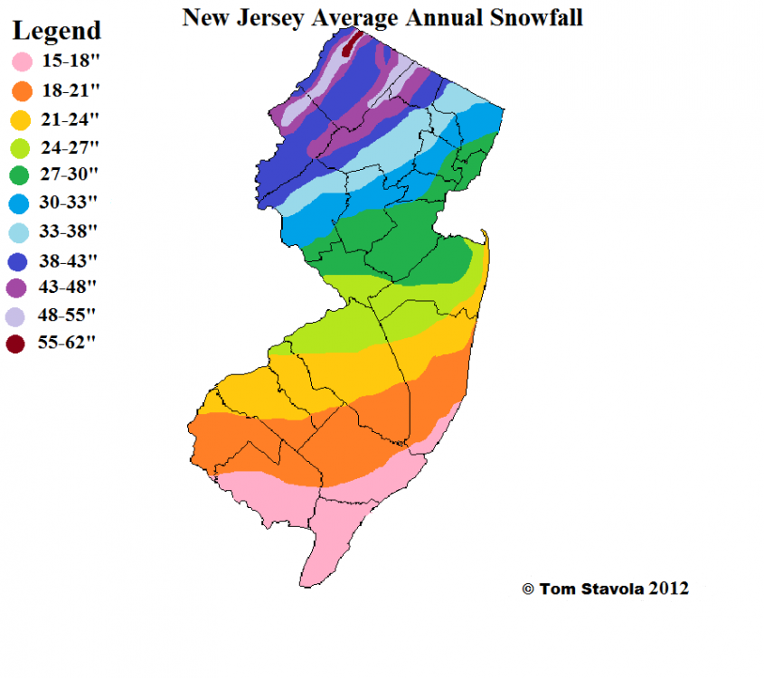
Good to see you back. I dunno about the Monmouth comp. There is some degree of bad luck here. Not denying that. So your point isn’t totally wrong. But able averages across that country range from about 24-28” in most places. I grew up in NJ. I would choose that area over DC or Balt for snow 9/10 times. DCs snow climo is similar to along the pink/orange line and Baltimore’s is closer to somewhere in the northern side of the Orange zone. Those areas haven’t been doing that good wrt snow recently either. Same sharp cutoff there too!
-
I honestly think it was more a failure of where that band set up then the warm layer. I mean the fact that weak layer was there hurt of course but we knew it was. Had the band of steady heavy precip that set to from Winchester to me been along 95 like all guidance said I bet they get a couple inches of snow before the mid level warmth got too bad then tank on a couple inches of sleet snow mix later. Instead the banding set up NW and you dry slotted while the warm layer moved in unimpeded then had to try to mix it out when heavier precip did move in. That didn’t work. One of the most disappointing aspects though, and more evidence that whole specific discreet details for each event contributed there is definitely a larger factor with its thumb on the scale, is how this storm did get suppressed WAY more then I thought it would and it STILL did DC no good. Maybe I should have been worried about suppression because only about 25 miles north of me in PA their saying “where did all the precip go I got 2” what happened to the 6-12 all guidance showed for the last week” lol. I was 20 miles from being fringed and 10 miles the other way from a fail due to mixing! That kind of thing seems to be a theme way too often. This is the 3rd time this season alone I was on the northern fringe of a snowstorm and DC couldn’t cash in. That’s not normal historically!
-
It’s BAD here....freezing mist had coated everything in solid ice. No way I could get back up my 1/4 mile drive if I left. Cant even walk up it had to walk in the snow. Would have been better off leaving the 8” of crud all over it. Honestly.
-
I’ll have to go back through my records but this might be the greatest disparity between my area and DCA/BWI ever. I’m at 45” now and very likely not done. I don’t think there was ever a 50”+ winter here that DC or BWI was in the single digits. The thing is the results here match the pattern WAY better then the results along 95. My opinion on what’s partially at play is well known.


